2:00 PM | ***Impactful storm system to reach south-central US tonight after pounding California/SW US…significant snow, excessive rain, damaging ice, severe storms on the table next couple days***
Paul Dorian

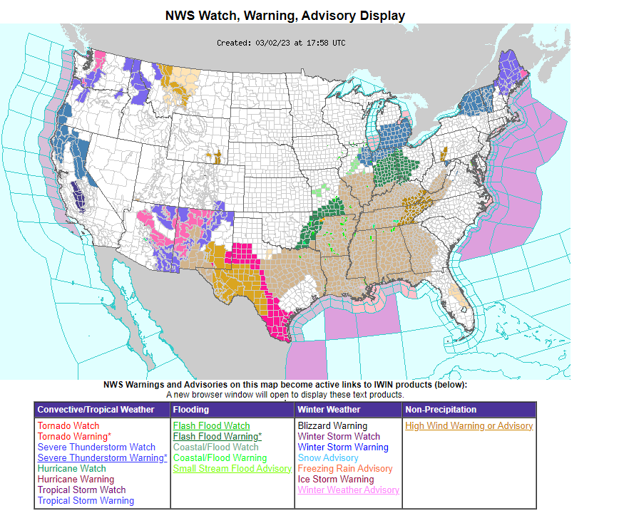
A major storm system continues to wreak havoc on much of the nation with “watches and warnings” all over the place. Next on the list for this system will be flash flooding from the Mississippi Valley to the Ohio Valley and the potential for heavy snow from the Upper Midwest to New York/New England. In addition, severe weather is a threat from later today into Friday in the south-central US and those types of “watches and warnings” will very likely be issued later in the day (e.g., tornado, severe thunderstorm). Map courtesy NOAA/WPC
Overview
A very impactful storm system will slide out of the SW US later today and begin to intensify over the south-central states by later tonight. After slamming California and the southwestern states, this system will bring accumulating snow, excessive rain, and damaging ice to parts of the eastern half of the nation during the next couple of days. In addition, this system will contribute to a potential severe weather outbreak from later today into Friday across the south-central US.

Yosemite National Park in California has been forced to close down for awhile due to excessive snowfall with as much as 40 inches on the valley floor.
Details
Strong low pressure pounded California and the Southwest US during the past couple of days and it will slide eastward to the south-central US by later tonight. Significant snow fell in the higher elevations of California from this storm system with the Sierra Nevada receiving up to 10 feet of snow which piled up on an already extremely deep snowpack. Yosemite National Park in California has actually been forced to close down indefinitely due to excessive snow amounts of 40+ inches on the valley floor. To the southeast, significant snow fell in other national parks including Grand Canyon in Arizona, Zion and Bryce in Utah, and the high elevation city of Flagstaff (AZ) now has its second snowiest totals ever for a given winter season up to the date of March 1st (140 inches). Currently, this major storm is slamming New Mexico with heavy snow across much of the northern half of the state and very windy conditions as well in much of that region.
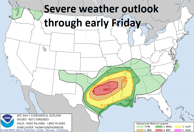
Severe weather is a threat later today/tonight and Friday across the south-central US including the possibility of isolated tornadoes. Map courtesy NOAA/SPC
By later tonight, this low pressure system will push eastward to the northeastern part of Texas and a stiffening flow of air from the Gulf of Mexico will pump in warm and humid air into the Deep South, Mississippi and Tennessee Valleys. The combination of intensifying low pressure and the buildup of warm, humid air will contribute to instability and the dual threats of severe weather and flash flooding in this part of the nation.

One of the ingredients increasing the chances for a severe weather outbreak is an influx of warm, humid air from the Gulf of Mexico into the southern US. Map courtesy NOAA, tropicaltidbits.com
On Friday, as this low pressure area pushes northeastward towards the Great Lakes, the threat of excessive rainfall and flash flooding will expand northward from the Tennessee Valley to the Ohio Valley. In addition, colder air on the storm’s northwest flank will result in accumulating snow in the Upper Midwest including in much of eastern Illinois, northern Indiana, and southern Michigan.

Significant snow can fall later tomorrow in the Upper Midwest across Illinois, Indiana and Michigan and just to the south of there, flash flooding-type rainfall is a strong possibility across the Ohio Valley. Map courtesy NOAA/WPC
As this storm system reaches the eastern Great Lakes region on Friday night, it’ll begin to feel the effects of intensifying high-latitude blocking over the northeastern part of Canada. As such, the primary (initial) low pressure system will grind to a halt and transfer its energy to a secondary low pressure system that is likely to form by late Friday night somewhere off the northern Mid-Atlantic coastline. Significant snow is likely to spread into New York State and New England by later tomorrow night and icing can become a major issue across much of northeastern PA (including the Pocono Mountains), Lower Hudson Valley (NY) and the Catskill Mountains.

Before this impactful storm system exits “out-to-sea”, it’ll likely produce significant snowfall in much of New York State and New England and there can be damaging icing in northeastern PA (including in the Poconos), Lower Hudson Valley (NY), and Catskill Mountains (NY). Map courtesy NOAA, tropicaltidbits.com
Farther to the south, it looks like this latest system will be primarily a rain event for the immediate DC-to-Philly-to-NYC corridor. However, sleet and even snow can mix in at times in the some of the northern and western suburbs of these metro areas. The rain can become heavy at times later tomorrow and tomorrow night in the Mid-Atlantic region; especially across eastern Pennsylvania, central and southern New Jersey and winds will increase noticeably during the event. There can even be drenching thunderstorms tomorrow night in the Mid-Atlantic’s I-95 corridor and coastal flooding is likely to become a concern from New Jersey down to the Delmarva Peninsula .

The intense drought conditions across California in the Fall of 2022 have been essentially eliminated in this very active weather pattern which is likely to continue into the month of April. Data courtesy US Drought Monitor/NOAA
On Saturday, as a result of the strong blocking aloft over northeastern Canada, the secondary low pressure system will be forced to move to the east rather than the more typical track to the north or northeast. This path will tend to cause the snow to linger on Saturday across much of New York State and New England. High pressure will return later in the weekend to calm things down as this coast-to-coast impactful storm finally exits to the open waters of the Atlantic Ocean. At the same time, a new storm will begin to impact northern California with a new round of higher-elevation snows and low-lying rains as this active weather pattern continues. One final note, the drought in California that was quite intense as recent as October of 2002 has been virtually wiped out by February of 2023.
Meteorologist Paul Dorian
Arcfield
arcfieldweather.com
Follow us on Facebook, Twitter, YouTube
Video discussion: