9:30 AM | *Cold air outbreaks to last into the first week of April from the Northern Plains to the Mid-Atlantic/NE US…pattern to produce snow threats in some areas, severe weather in others*
Paul Dorian

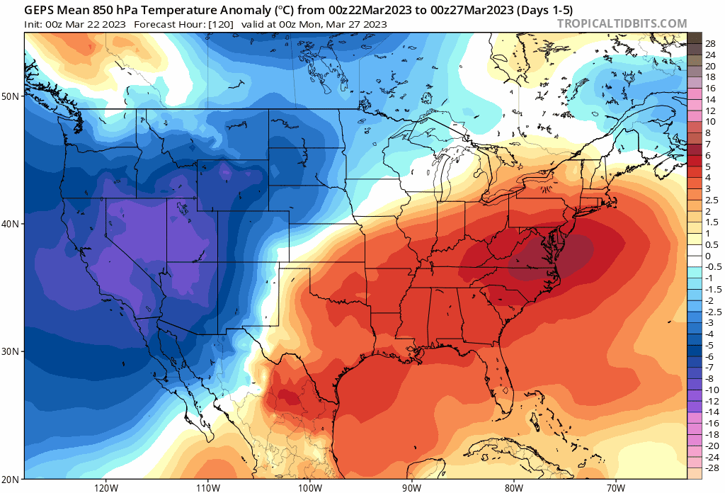
Cold air outbreaks look likely to continue into early April in the region from the Northern Plains to the Mid-Atlantic/Northeast US. These 5-day mean forecast maps by the 00Z GEPS feature colder-than-normal 850 millibar temperatures across much of the northern and western US into the first week of April. Maps courtesy Canadian Met Centre, tropicaltidbits.com
Overview
Spring has officially sprung and there is some quite mild weather expected during the next couple of days in much of the eastern half of the nation. There are signs, however, that point to additional cold air outbreaks into at least the first week of April from the Northern Plains to the Mid-Atlantic/Northeast US. The overall weather pattern across North America still features some high-latitude blocking over northern Canada and Greenland and this, in turn, is allowing for the transport of colder-than-normal air masses on occasion into the northern US from Canada. One of the consequences of additional cold air outbreaks is the high likelihood for additional accumulating snow events across the northern states and also the threat for severe weather outbreaks in the southern US. This pattern of normal to below-normal temperatures has been pretty commonplace during the last ten years in the months of March and April in the region from the Northern Plains to the Mid-Atlantic/Northeast US.

The average temperature anomaly in the ten year period from 2013-2022 during the months of March and April have featured colder-than-normal conditions from the Northern Plains to the Mid-Atlantic/Northeast US. map courtesy NOAA
Details
The month of February featured a stratospheric warming event in the polar region of the Northern Hemisphere and the tropospheric response has been high-latitude blocking across northern Canada and Greenland during the month of March. In response to the high-latitude blocking, the main jet stream aloft has been shunted to the south and this has allowed for the successful transport of colr air masses into the northern US from Canada in recent weeks.

This long-range forecast for the first week of April features high-latitude blocking (shown in orange) over northern Canada and Greenland and this, in turn, will allow for occasional cold air outbreaks into the northern states from Canada. Map courtesy Canadian Met Centre, tropicaltidbits.com
Signs point to this same kind of pattern continuing for at least another couple of weeks which will take us into the first week of April. While there will certainly be occasional days of warmer-than-normal weather, any given 5-day period over the next couple of weeks will likely average out to be colder-than-normal for this time of year from the Northern Plains to the Mid-Atlantic/Northeast US.

Accumulating snow will be a possibility this weekend across parts of Wisconsin and Michigan (left plot) and northern New England (right plot) aided by another cold air outbreak from Canada into the northern US. Maps courtesy Canadian Met Centre, tropicaltidbits.com
One consequence of additional cold air outbreaks is the likelihood for more accumulating snow events across the northern US; specifically, parts of the Upper Midwest and interior higher-elevations of the Mid-Atlantic and Northeast US. This weekend, for example, is likely to feature accumulating snow across parts of the Upper Midwest and ultimately across the interior Northeast US. Low pressure will push into the Upper Midwest on Saturday bringing some accumulating snow likely to portions of Wisconsin and Michigan and then ultimately, a second low pressure system will form off the New England coastline. This second system will likely bring some accumulating snow to upstate New York and interior northern New England by the mid-point of the upcoming weekend.

Not only is accumulating snow likely during the next 5 days or so over the western US, but also across the Upper Midwest, upstate NY and northern New England. Map courtesy Canadian Met Centre, tropicaltidbits.com
Another consequence of additional cold air outbreaks this time of year is the increased chance for severe weather outbreaks in the central and southern US. Cold air intrusions into the central states is often a key ingredient for severe weather outbreaks as long as warm, humid air from the Gulf of Mexico can join the picture. Indeed, by late Friday or Friday night, these two ingredients combined with intensifying low pressure can be the catalyst for a severe weather outbreak across the Lower Mississippi Valley.

The threat for severe weather is on the table later Friday in the Lower Mississippi Valley with cold air to the north and west, and warm, humid air to the south and east. Map courtesy NOAA/SPC
Meteorologist Paul Dorian
Arcfield
arcfieldweather.com
Follow us on Facebook, Twitter, YouTube
Video discussion: