11:30 AM | ****Active pattern continues…severe weather outbreak…flooding rains...weekend snow threats Upper Midwest/interior NE US…possible storms near both coasts by next mid-week****
Paul Dorian
Strong upper-level support will combine with intensifying surface low pressure, an influx of warm, humid air, and a shot of cold, dry air from the north/west to generate a severe weather outbreak from later Friday into Friday night. The main threat area for severe weather will be across the Lower Mississippi Valley. Map courtesy ECMWF, Pivotal Weather
Overview
We are now a few days into spring season and the active weather pattern that lasted through much of the winter across the nation looks like it can continue well into the month of April. California was pounded by yet another storm on Wednesday that the state brought heavy rain, significant snow, and even a rare tornado to the Los Angeles metro region. Some severe weather is possible later Thursday across Texas and Oklahoma, but it is even more likely from later Friday into Friday night across the Lower Mississippi Valley. Meanwhile, in the colder climate of the northern US, there can be accumulating snow this weekend in the Upper Midwest and then upstate New York/northern New England. And finally, while still in the speculation phase, this active weather pattern may result in strong new storms near both coasts by the middle of next week.
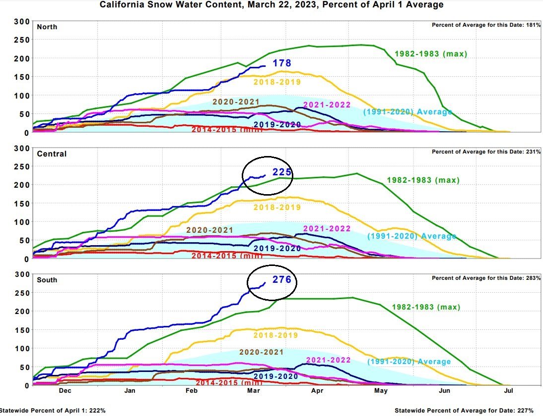
The latest California storm brought more significant snowfall to the Sierra Nevada Mountains in the eastern part of the state which has brought totals to record “snow water content” levels in the central and southern sections. Yet another storm may slam into California by the middle of next week.
Details
Several weather events to focus in on today that will impact many parts of the country in coming days as the overall active weather pattern that began this winter continues likely well into the month of April. The latest storm that pounded California yesterday will slide into the middle of the nation by Friday and then it’ll push northeast to the Great Lakes early this weekend. This latest storm again brought California some heavy rain in low-lying coastal sections, significant accumulating snow to the higher elevations (e.g., Sierra Nevada), and there was even a rare tornado in the Los Angeles metro region (Montebello) – the strongest one in LA County since 1983 (classified as an EF-1).
A severe weather outbreak is possible from later Friday into Friday night with a focus warning area in the Lower Mississippi Valley. Map courtesy NOAA/Storm Prediction Center
As the upper air support from this California storm system slides east, it will combine with a frontal boundary zone to generate heavy - and potentially flooding - rainfall in the region from Oklahoma-to-Ohio from late Thursday into Friday. In addition, this upper air feature will help to generate a strong and intensifying surface low pressure system later Friday in the south-central US and this will draw some warm and humid air from the Gulf of Mexico into the southern states. These two ingredients and colder air moving in from the west side of the low can help to generate a severe weather outbreak later Friday into Friday night across the Lower Mississippi Valley region with tornadoes certainly on the table.
Heavy rainfall is coming to the region from Oklahoma-to-Ohio from later Thursday into Friday and this can result in some serious flooding problems across that part of the nation. Map courtesy ECMWF, Pivotal Weather
On Saturday, this strong low pressure system over the south-central states will push northeastward to the Great Lakes and it’ll encounter some colder air. The end result will likely be some early spring accumulating snow on Saturday across parts of northern Illinois, southeastern Wisconsin, and Michigan. Ultimately, a secondary low pressure system is likely to form this weekend off the New England coastline and this will combine with the initial primary low to generate accumulating snow across portions of upstate New York, and across northern New England.
Accumulating snow is likely this weekend in portions of the Upper Midwest and the interior Northeast US. One low pressure system will push to the Great lakes and a second will develop off the New England coastline. Map courtesy NOAA (GFS), tropicaltidbits.com
If all that activity isn’t enough, there is potential that by the middle of next week both coasts can become impacted by new strong storm systems. While still several days away and still in the speculation phase, there are some signs that by the middle of next week another storm may be ready to slam into California from the eastern Pacific Ocean. At the same time, strong low pressure could form somewhere off the eastern seaboard and this potential system would likely have plenty of cold air to work up across the interior part of the Northeast US.
While still several days away, signs point to low pressure somewhere near east coast by the middle of next week and yet another Pacific Ocean storm may head into California. Map courtesy ECMWF, Pivotal Weather
Stay tuned…a lot of impactful weather events happening all across the nation in coming days.
Meteorologist Paul Dorian
Arcfield
arcfieldweather.com
Follow us on Facebook, Twitter, YouTube
Video discussion:


