
10:30 AM | ***Another severe weather outbreak on the way from later tomorrow into Wednesday likely to include numerous tornadoes…substantial accumulating snow from the Rockies to the Dakotas***
Paul Dorian

One of the main ingredients in the upcoming severe weather outbreak will be an intensifying upper-level (300 millibars) jet streak that will be centered over the middle of the nation by late Tuesday night. This upper-level jet streak will combine with a low-level (850 millibars) jet streak to generate deep-layer wind shear raising the chance for tornadic activity across the Mississippi Valley/Ohio Valley. Map courtesy ECMWF, Pivotal Weather
Overview
There have been back-to-back weeks with severe weather outbreaks in the US and it looks like another one is on the way from later tomorrow into Wednesday. The areas of concern include the Mississippi and Ohio Valleys and the ingredients that will come together to destabilize the atmosphere include jet streaks at multiple layers, cold, dry air mass charging to the south and east, and warm, humid air flowing northward from the Gulf of Mexico. Tornadoes are running at above-normal levels across the nation so far this season thanks in large part to the recent two outbreaks and, unfortunately, many more are likely from later tomorrow into Wednesday. Meanwhile, in the cold sector of the storm system, the air will be cold enough for accumulating snow all the way from the Rockies to the Dakotas and, in some spots, this could amount to as much as 1-2 feet.

One of the main ingredients in the upcoming severe weather outbreak will be an intensifying low-level (850 millibars) jet streak that will be centered over the Mississippi Valley by late Tuesday night. This low-level jet streak will combine with an upper-level (300 millibars) jet streak to generate deep-layer wind shear raising the chance for tornadic activity across the Mississippi Valley/Ohio Valley. Map courtesy ECMWF, Pivotal Weather
Details
There is a risk of severe thunderstorms later tomorrow afternoon and evening across the Mississippi Valley region from Iowa/Illinois to the north and Louisiana in the south. In much the same manner as with recent severe weather outbreaks, a vigorous upper-level trough will help to spawn surface cyclogenesis in the middle of the nation at the same time high-level ridging intensifies over the eastern states. An intensifying upper-level jet streak (southwesterly winds) will push into the Great Plains and then the Mississippi Valley region and a low-level jet (southerly winds) will play a crucial role as well. The combination of these two jet streaks at multiple layers of the atmosphere will lead to deep-layer wind shear in the warm sector of the surface low pressure system - potentially leading to supercells capable of producing tornadoes.
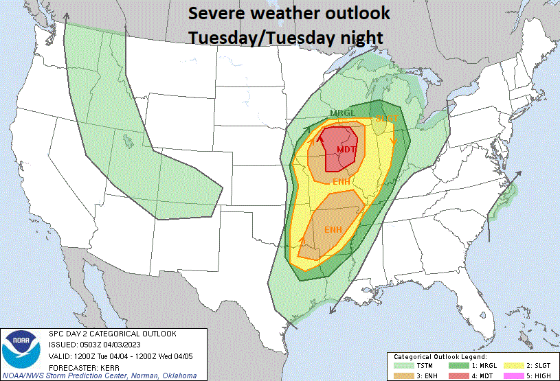
An increasing risk of severe weather will be centered in the Mississippi Valley region from later tomorrow into the overnight hours of early Wednesday. The threat of severe weather will then shift to the Ohio Valley/lower Great Lakes later in the day on Wednesday and to the eastern seaboard on Thursday. Plot courtesy NOAA/SPC
By Wednesday, the threat of severe weather will shift to the east with thunderstorms capable of producing tornadoes reaching the lower Great Lakes and the Ohio Valley. As the surface cold front pushes to the east on Wednesday, the cold and dry air mass on its backside will clash with warm and humid air that should be able to reach all the way up into the lower Great Lakes from the Gulf of Mexico. This same surface cold front will push towards the eastern seaboard on Thursday and there can be isolated strong-to-severe thunderstorms near the coast to go along with breezy and warm conditions with temperatures likely climbing into the 70’s across much of the Mid-Atlantic.
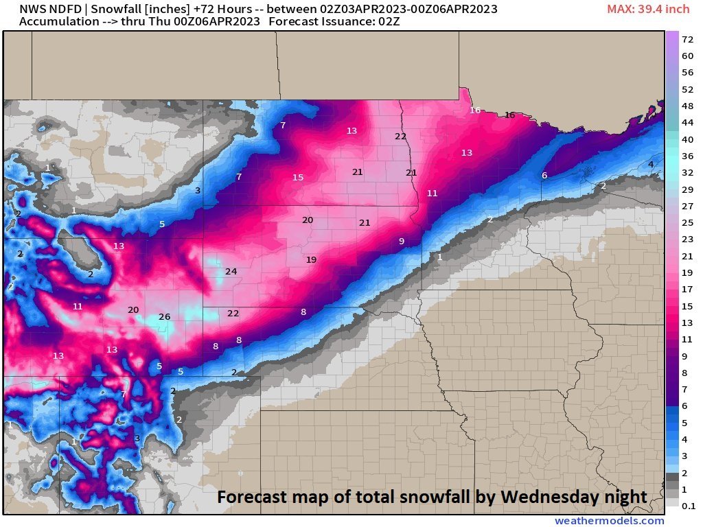
In the cold sector of this storm system, there will plenty of cold air to support accumulating snow all the way from the Rockies to the Dakotas and northern Minnesota. In fact, the possibility exists for as much as two feet of snow during the next 72 hours or so in this part of the nation. Map courtesy weathermodels.com (Dr. Ryan Maue, Twitter), NOAA
One final note, this unfolding weather pattern will not only produce numerous tornadoes from later tomorrow into Wednesday in a severe weather outbreak, it is likely to also result in significant accumulating snow. Specifically, the region from the Rockies to the Dakotas and northern Minnesota will see some substantial snowfall during the next 72 hours or so with as much as 1-2 feet in some locations.
Meteorologist Paul Dorian
Arcfield
arcfieldweather.com
Follow us on Facebook, Twitter, YouTube
Video discussion: