
12:45 PM (Monday) | ****Severe thunderstorms with hail, damaging wind gusts and even isolated tornadoes…all on the table in the Mid-Atlantic…watch for torrential downpours and flash flooding****
Paul Dorian

Low pressure over the Great Lakes will feature a “negatively-tilted” trough axis which will produce strong upward motion in the Mid-Atlantic region. As a result, there will be a severe thunderstorm threat later today into tonight in the DC-to-Philly-to-NYC corridor and torrential downpours can produce localized flash flooding. Map courtesy NOAA, tropicaltidbits.com
Overview
The atmosphere will quickly destabilize today in the Mid-Atlantic region raising the chance for severe thunderstorm activity later today and early tonight. Any thunderstorm can produce large hail, damaging wind gusts and even isolated tornadoes. Torrential rainfall can lead to flash flooding conditions in the Mid-Atlantic region; especially, in those areas hit hard by downpours this past weekend. The threat for strong-to-severe thunderstorms will continue on Tuesday and the overall wet weather pattern looks like it’ll resume at week’s end after a short-break and continue into the first half of next week.

NOAA’s Storm Prediction Center places much of the eastern and southern Mid-Atlantic region in an “enhanced” threat zone for the possibility of severe thunderstorm activity later today and tonight. Map courtesy NOAA/SPC
Details
The atmosphere will become increasingly unstable today in the Mid-Atlantic region with a combination of ingredients coming together. First, low pressure in the upper part of the atmosphere has pushed into the Great Lakes region and its trough axis has taken on a “negative-tilt” (i.e., oriented from northwest-to-southeast) which enhances upward motion on its eastern side…in this case that “enhancement” is in the Mid-Atlantic region. In addition, low pressure at the surface level over the Great Lakes has resulted in a low-level flow of air from the south-to-southeast in this area and this has pumped in very humid air aiding in the instability of the atmosphere. Finally, a surface cool frontal system is edging its way into the eastern states increasing low-level convergence which is also adding “fuel to the fire”.

Lines and clusters of thunderstorms will develop later today into tonight and many of these will reach severe levels with the potential of large hail, damaging wind gusts and even isolated tornadoes. Watch out for flash flooding with expected torrential rainfall and power outages are on the table as well for later tonight. Map courtesy NOAA, tropicaltidbits.com
Showers and thunderstorms this morning have been isolated across eastern Pennsylvania and New Jersey, but by mid-day and early afternoon radar echoes should begin to develop across western sections of the Mid-Atlantic. Aided in part by plenty of daytime heating, several lines and clusters of thunderstorms should develop during the early-to-mid afternoon hours originating mainly over higher terrain areas in the central and western Mid-Atlantic. From later today into tonight, thunderstorms will be pushing towards eastern sections of the Mid-Atlantic with the most probable time period for severe weather being 4-10pm in the immediate DC-to-Philly-to-NYC corridor. Any storm later today and tonight can produce large hail, damaging wind gusts and even isolated tornadoes.
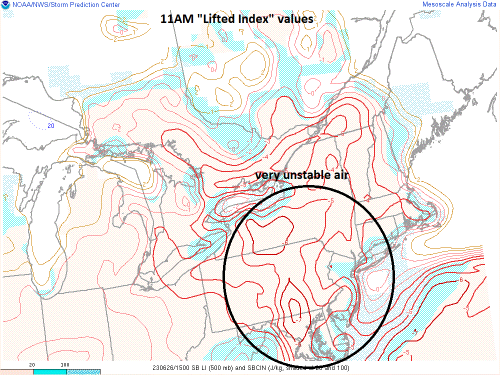
One of the atmospheric stability indices looked at by weather forecasters is called the “lifted index”. This map from 11AM features “lifted index” values as low as -7 in the Mid-Atlantic region (e.g., south-central PA) which is indicative of a very unstable air mass. Map courtesy NOAA/SPC
Torrential downpours later today and early tonight can result in flash flooding conditions in the Mid-Atlantic region; especially, in those areas hit hard by heavy rainfall this past weekend (e.g., eastern PA). The threat of severe storm activity and torrential rain will diminish in the late night hours with the loss of the impact of daytime heating and patchy fog is likely to form in many spots given very high surface moisture levels.

On Tuesday, as a slow-moving cool front edges its way through the eastern states, the chance of strong-to-severe thunderstorm activity will remain in much of the Mid-Atlantic region including in the immediate DC-to-Philly-to-NYC corridor. Map courtesy NOAA, tropicaltidbits.com
On Tuesday, the slow-moving surface cool front and upper-level low pressure system over the eastern Great Lakes will still produce plenty of instability in the Mid-Atlantic region. As a result, there can be more strong-to-severe thunderstorm activity in the DC-to-Philly-to-NYC corridor from tomorrow afternoon into early tomorrow night. Looking ahead, there may be slight improvement in weather conditions later Wednesday and Thursday, but the overall wet weather pattern in the Mid-Atlantic region looks like it will resume at week’s end and continue into at least the first half of next week with a renewed chance of daily showers and thunderstorms.
Meteorologist Paul Dorian
Arcfield
arcfieldweather.com
Follow us on Facebook, Twitter, YouTube
Video discussion: