
12:15 PM | *Heavy rainfall amounts last 30-days in the eastern US…a concern as we head into the heart of the tropical season*
Paul Dorian

Excessive rainfall amounts of more than ten inches has taken place during the past 30-days in virtually every state from Florida-to-Maine. Map courtesy NOAA/ESRI
Overview
More than ten inches of rain has fallen during the past 30-days in virtually every state from Florida-to-Maine. These excessive rainfall amounts are quite impressive considering the fact that tropical moisture has not really been involved in the overall weather pattern other than perhaps across Florida earlier in the tropical season. In fact, the heart of the Atlantic Basin tropical season lies ahead beginning typically during the month of August and continuing into October with the climatological peak right around the middle of September. There is nothing yet on the horizon for the eastern US in terms of tropical activity; however, there is a concern that should a tropical system impact this region in coming weeks, the currently very well saturated grounds could set the stage for some flooding issues.

The active weather pattern in recent weeks has produced more than ten inches of rain in many parts of the eastern US. The next ten days will bring additional impressive rainfall amounts; especially, across the northeastern states where they don’t need it. Map courtesy NOAA/WPC, tropicaltidbits.com
Details
The tropical season in the Atlantic Basin tends to ramp up noticeably during the month of August, reaches a climatological peak around the middle of September, and then begins to ramp down in October. The official end of the tropical season in the Atlantic Basin is December 1st as so designated by NOAA’s National Hurricane Center; however, there has been some tropical activity in recent years right into the late stages of the calendar year. So far this season, there have been four named tropical systems with subtropical “Don” currently still active, but way out in the open waters of the central Atlantic Ocean where it is not going to impact land. The earlier systems in 2023 included Tropical Storm Arlene which formed over the eastern Gulf of Mexico in late May/early June. Tropical Storm Bret formed during mid-June in the eastern part of the tropical Atlantic Ocean and Tropical Storm Cindy formed on its heels in the tropical Atlantic after pushing off the west coast of Africa.

A stubborn upper-level low over south-central Canada has helped to create an active weather pattern in the eastern US in recent days. Multiple waves of energy have rotated through the base of this upper-level trough enhancing upward motion in, for example, the Mid-Atlantic region and Northeast US. This active weather pattern is not done quite yet and another wave approaches from the northwest later tomorrow and yet another during the latter part of the week. Map courtesy NOAA, tropicaltidbits.com
In terms of the recent rainfall, a very active pattern developed in the eastern states during the month of June and it has continued into July. This wet pattern actually followed a very dry stretch of weather in the Mid-Atlantic region and Northeast US where rainfall amounts were far below-normal during May and part of June. In coming days, the active pattern will continue across much of the eastern US with multiple waves of energy continuing to rotate through the base of a large-scale upper-level trough still positioned over south-central Canada. One such wave will increase chances for PM showers and thunderstorms later Tuesday and then other systems will bring additional chances of rain from late Wednesday into Friday.
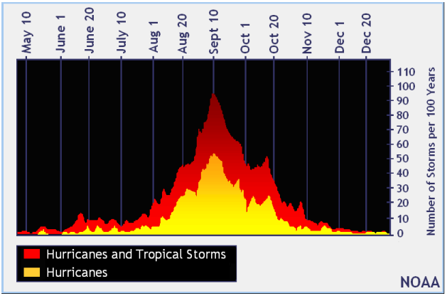
Hurricane season for the Atlantic Basin, which includes the Atlantic Ocean, the Caribbean Sea, and the Gulf of Mexico, runs officially from June 1st through November 30th. The climatological peak of the season occurs around September 10th, as seen in the graph above. There is a secondary peak around the middle of October that is mainly for the Caribbean Sea and the Gulf of Mexico region. After this second peak, the number of storms drops off quickly through the end of the season. Plot courtesy NOAA
Looking ahead, we’ll be keeping our eyes on the tropics as we head into the heart of the Atlantic Basin tropical season with a concerning feeling in the back of our minds given the very well saturated grounds in the eastern US.
Meteorologist Paul Dorian
Arcfield
arcfieldweather.com