11:50 AM (Sat.) | ***Big-time changes coming to the Mid-Atlantic with much more comfortable conditions from Sunday through Wednesday…transition to bring another round of heavy showers/severe storms***
Paul Dorian

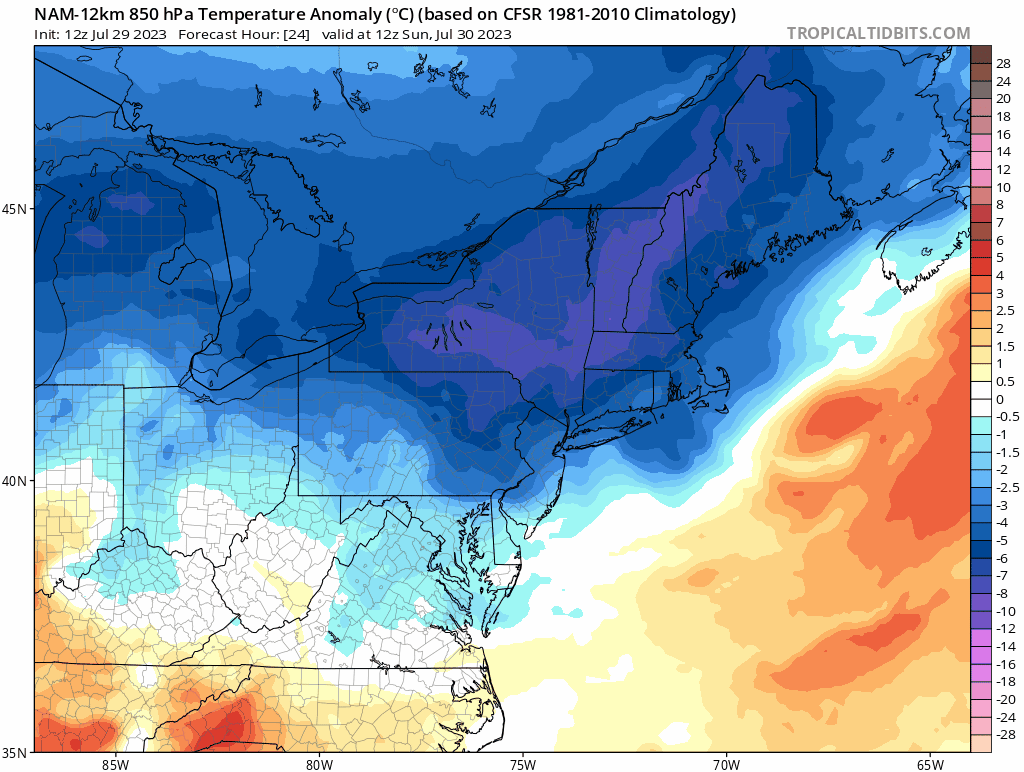
Big-time changes are coming to the Mid-Atlantic region following the passage of a strong cool front later tonight. This front is likely to be preceded by yet another round of heavy showers and strong-to-severe thunderstorms in an already well saturated part of the country. Maps courtesy NOAA, tropicaltidbits.com (850 mb temperature anomalies from 24 hours to 84 hours)
Overview
A big-time change is coming to the Mid-Atlantic region with much more comfortable conditions for Sunday, Monday, Tuesday and Wednesday. The transition from the brief stint of high heat and humidity to the cooler temperatures and lower humidity will come with another round of heavy showers and strong thunderstorms. A cool front drops southeast today across the eastern Great Lakes and passes through the Mid-Atlantic in the overnight hours paving the way for those big-time changes.

While not everyone along the I-95 corridor will get hit, yet another round of strong-to-severe thunderstorms is coming later today into tonight as we transition from high heat and humidity to much lower temperatures and dew points. Map courtesy NOAA, tropicaltidbits.com
Details
The last two days saw temperatures peak at 96 degrees in Washington, D.C. (DCA), 94 degrees in Philly (PHL) and 92 degrees in Central Park (NYC). Today will still feature high heat and humidity, but big-time changes are coming for the I-95 corridor. A strong cool front is now dropping south and east across the eastern Great Lakes and it will clear through the Mid-Atlantic coastline by late tonight. Following the passage of this front, much more comfortable air will push in on Sunday with noticeably lower temperatures and humidity levels.

NOAA’s Storm Prediction Center places the I-95 corridor in a “slight risk” of severe thunderstorm activity later today into early tonight.
By Sunday night, it will feel much, much different in the Mid-Atlantic compared to the past couple of days. The new work week will begin with high temperatures not all that far from the 80 degree mark in the DC-to-Philly-to-NYC corridor which is well below-normal for the last day of July. A reinforcing shot of comfortably cool air will works its way into the Mid-Atlantic region by Tuesday from southeastern Canada and this next shot will assure comfortable weather right through mid-week.
The transition to the cooler and less humid air mass may come at a price. An already soaked Mid-Atlantic region is likely to have to suffer through another round of heavy showers and strong-to-severe thunderstorms later today and early tonight. While not every spot in the I-95 corridor is guaranteed to get hit, any shower that forms later today can produce heavy rainfall and any thunderstorm can reach severe levels with the potential of damaging wind gusts and hail in addition to flash flooding type of rainfall. The chance of rain will certainly diminish through the first half of next week, but will increase once again in the late week as another frontal system closes in on the eastern US.
Meteorologist Paul Dorian
Arcfield
arcfieldweather.com
Follow us on Facebook, Twitter, YouTube