9:15 AM | *Cooler-than-normal air masses to impact much of the nation as we progress through August…summer so far has featured nearly normal temperatures on a nationwide basis*
Paul Dorian

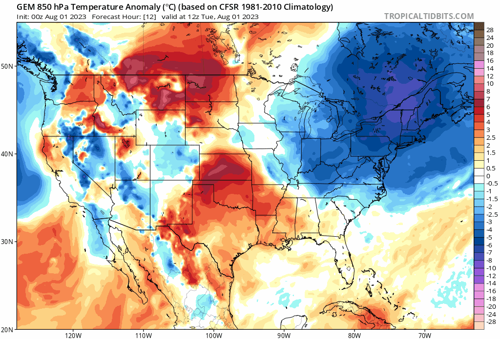
The 00Z Canadian computer forecast model features numerous cooler-than-normal air masses to drop into the US from Canada over the next ten days. Maps courtesy Canadian Met Centre, tropicaltidbits.com
Overview
It looks like the month of August will feature multiple cooler-than-normal air masses dropping into the US from Canada which continues a trend that has encompassed much of the summer season so far and impacted large areas of the country. The one areal exception to this pattern has been the Southwest US where intense upper-level ridging has resulted in persistent excessive heat during the past several weeks. These intrusions of cooler-than-normal air this summer has balanced out the excessive heat in the Southwest US leaving the nation with nearly normal temperatures as we begin the month of August.

Temperatures across the Lower 48 have been nearly normal since June 1st (+0.49 degrees (F)) with warmer-than-normal conditions concentrated across the south-central states and northern tier while cooler-than-normal temperatures stretched from California to the Carolinas. Map courtesy PRISM, Oregon State University, Dr. Ryan Maue (Twitter), weathermodels.com
Details
Since the beginning of the meteorological summer season on June 1st, the excessive heat in the southwestern states has been largely balanced out by cooler-than-normal conditions stretching from California to the Carolinas. The actual result has been an overall nearly normal summer season so far across the Lower 48 in terms of surface temperatures. It appears as though the month of August will continue a pattern that has featured cooler-than-normal air masses dropping from Canada into the US at the same time hotter-than-normal conditions persist in the southwestern states.

NOAA’s CFS model has a 2-meter temperature anomaly forecast for the month of August that features below-normal temperatures in the central and northern Plains and above-normal conditions across the Southwest US and in the Pacific NW. Map courtesy NOAA, Weather Bell Analytics (Joe Bastardi, Twitter)
In the Mid-Atlantic region and Northeast US, temperatures have averaged very close-to-normal normal during the months of June and July with June slightly below-normal and July slightly above normal. A few examples along the I-95 corridor include Philly and Washington, D.C. at minus 0.8 degrees, New York City at minus 0.3 degrees, and Boston featuring minus 0.4 degrees in the summer season so far.

NOAA’s United States Historical Climatology Network (USHCN) is a high-quality data set of daily and monthly records of basic meteorological variables from 1218 observing stations across the 48 contiguous United States. Daily data include observations of maximum and minimum temperature, precipitation amount, snowfall amount, and snow depth; monthly data consist of monthly-averaged maximum, minimum, and mean temperature and total monthly precipitation. Most of these stations are U.S. Cooperative Observing Network stations located generally in rural locations, while some are National Weather Service First-Order stations that are often located in more urbanized environments. Through the end of July, 53% of the USHCN stations reached 95 degrees (F) which is the lowest on record for the time of year and much lower than the peak of 93% that occurred in 1931. Map courtesy NOAA/NCEI/USHCN, Tony Heller (Twitter)
The hottest weather this summer in the Mid-Atlantic/Northeast US took place in a 3-day period from late last week into the first half of the weekend. In Washington, DC, for example, the heat wave featured high temperatures of 96, 96 and 97 degrees respectively last Thursday, Friday and Saturday. The reading of 96 degrees in Washington, D.C. (at Reagan Nation Airport, DCA) on Thursday, July 27th was the first time all summer that the thermometer reached 95 degrees or higher and this is the latest first time reading in a summer season since 2004. Another note about the Washington, DC, the 97 degrees that was reached on Saturday, July 29th was the highest observation this summer. While it came close last Saturday, the thermometer failed to reach triple digits and if we get to August 11th without hitting triple digits (a good possibility), it would be the 5th longest such streak in DC without reaching the 100° mark. On a nationwide basis, the percent of weather stations in the US Historical Climate Network that reached 95 degrees or higher by the end of July was actually at a historic low with only 53% as compared with, for example, the highest on record of 93% in 1931.
Meteorologist Paul Dorian
Arcfield
arcfieldweather.com