
12:45 PM | ***Idalia to reach “major” hurricane status before landfall early tomorrow…remnants of Idalia to meander off the coast...Franklin heads for the North Atlantic***
Paul Dorian

Hurricane Idalia continues to intensify as it encounters a more favorable environment with diminished wind shear and is likely to attain “major” hurricane status of category 3 or higher before expected landfall early Wednesday along Florida’s Gulf coast. Hurricane Franklin has weakened a bit, but still maintains category 4 (“major”) classification at this time and it is headed to the open waters of the North Atlantic. Images courtesy NOAA/NESDIS
Overview
Hurricane Idalia continues to intensify today as it encounters more favorable environmental conditions with diminished wind shear and it is likely to attain “major” classification of category 3 or higher before making landfall early tomorrow along Florida’s Gulf coast. Hurricane Idalia will then turn northeast, weaken slowly, and push towards the Carolina coastline as it becomes increasingly influenced by building high pressure ridging aloft to its west and north. As a result of the developing widespread upper-level ridge, Idalia will likely meander over the western Atlantic Ocean for several days and there is even an outside chance that it could loop back around to revisit Florida in a weakened state about a week from now. Meanwhile, Hurricane Franklin maintains status as a category 4 “major” system. It will pass to the northwest of Bermuda on Wednesday bringing tropical storm conditions to the island. After that, Hurricane Franklin will push northeastward to the open waters of the North Atlantic as southwesterly flow ahead of an incoming upper-level trough steers it in that direction.
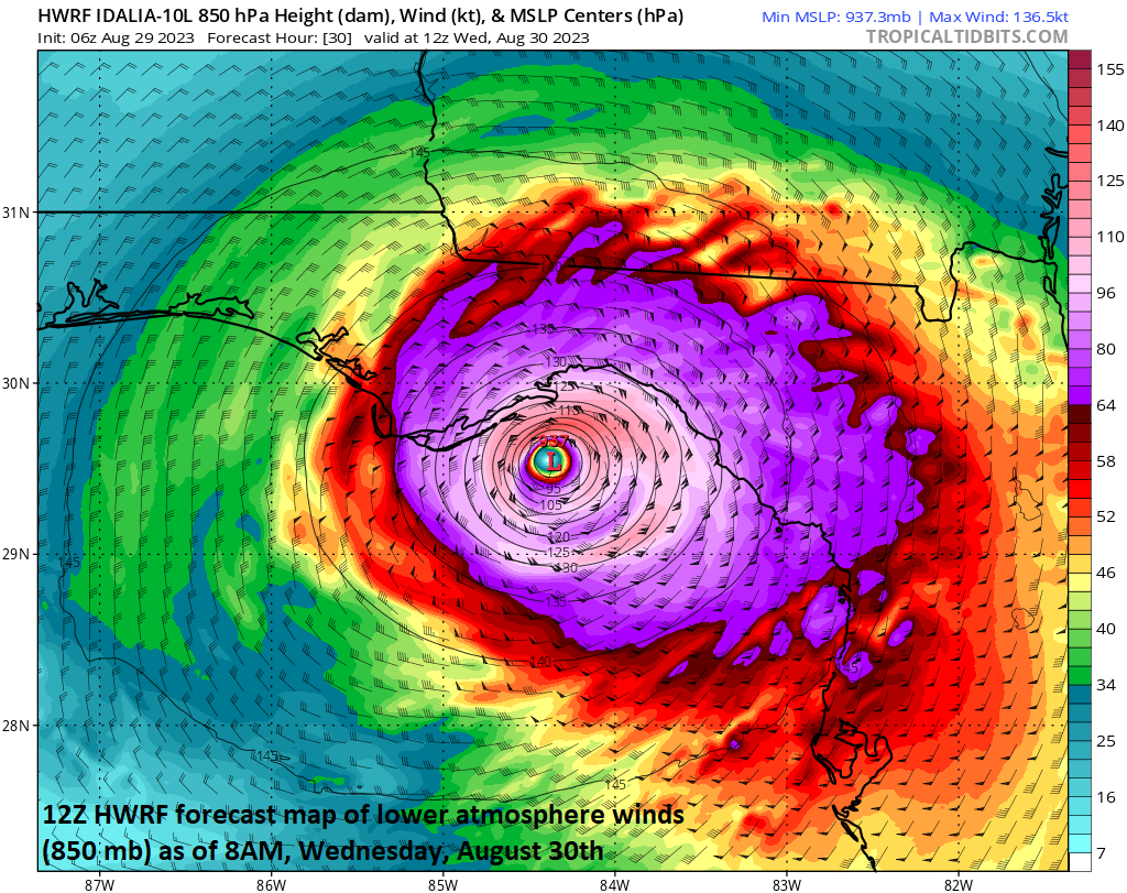
Hurricane-force winds will develop by later tonight along Florida’s Gulf coast and continue into the day on Wednesday with the expected landfall of Hurricane Idalia on Wednesday morning. Map courtesy NOAA (HWRF), tropicaltidbits.com
Hurricane Idalia
Idalia reached category 1 hurricane status in the overnight hours and now has maximum sustained winds of 85 mph with movement to the north at 14 mph. Hurricane Idalia will continue to strengthen today as it climbs over the warmer-than-normal waters of the eastern Gulf of Mexico and encounters diminishing wind shear with upper-level ridging building overhead. Given the expected intensification, Idalia is likely to reach “major” hurricane status as a category 3 or higher before making landfall early Wednesday along Florida’s Gulf coast (Big Bend region to the northwest of Tampa). This may turn out to be the strongest landfalling hurricane along these coastal areas since the 1896 Cedar Keys hurricane (125 mph winds).
Heavy rain bands have already spread northward to the Gulf coast of Florida and will intensify during the next several hours. Tropical storm force winds will develop later today and hurricane-force winds later today into the day on Wednesday across Florida’s Gulf coast. A dangerous storm surge is a threat along Florida’s Gulf coast from Englewood to Indian Pass and including the Tampa Bay region. As much as 10-15 feet above ground level is possible in the region between Aucilla River and Yankeetown if the peak storm surge takes place around high tide.

Heavy rain bands have already reached the northern Gulf coast of Florida and torrential rain will fall tonight and on Wednesday with the expected landfall of Hurricane Idalia on Wednesday morning. Map courtesy NOAA (HWRF), tropicaltidbits.com
After landfall early tomorrow, Hurricane Idalia will turn to the northeast, weaken slowly, and likely arrive near or over the Carolina coastline by early Thursday. At this point in time, high pressure aloft will begin to build to the west and north of Idalia with North Carolina likely the farthest north this tropical system can reach. With building high pressure ridging to its west and north, Idalia will likely push off the Carolina coastline by later in the week and then meander off the coast for several days. In fact, there is a scenario that could result in a “loop” of the remnants of Idalia this weekend and it could actually revisit Florida in about a week’s time as a weakened system.

Storm surge can reach levels as high as 10-15 feet above ground level in the Aucilla River to Yankeetown region if peak arrives with high tide. Map courtesy NOAA
Hurricane Franklin
Hurricane Franklin is still categorized as a category 4 “major” hurricane this morning despite a bit of weakening with a well-defined eye and maximum sustained winds of 130 mph. This powerful hurricane will bring tropical storm conditions to Bermuda on Wednesday as it makes its closest approach to the island, and will then become influenced by a deep upper-level trough that moves off the NE US/SE Canada coastlines. The upper-level trough will help to steer Franklin to the northeast in a broad southwesterly flow and this ensures Franklin will spend its foreseeable future out over the open waters of the North Atlantic. Eventually, the remnants of Franklin could actually impact Iceland or the United Kingdom after it travels all the way across the northern Atlantic Ocean.

Southwesterly winds on the front side of an incoming upper-level trough will help to steer Hurricane Franklin out into the open waters of the North Atlantic. Hurricane Franklin will pass Bermuda to the northwest on Wednesday producing tropical storm conditions and ultimately can end up impacting Iceland or the United Kingdom several days down the road. Map courtesy NOAA/NHC
Meteorologist Paul Dorian
Arcfield
arcfieldweather.com
Follow us on Facebook, Twitter, YouTube
Video discussion: