
10:15 AM | *Another potent system to monitor for the early part of next week…could threaten the Mid-Atlantic region with another round of severe weather by late Monday/Monday night*
Paul Dorian
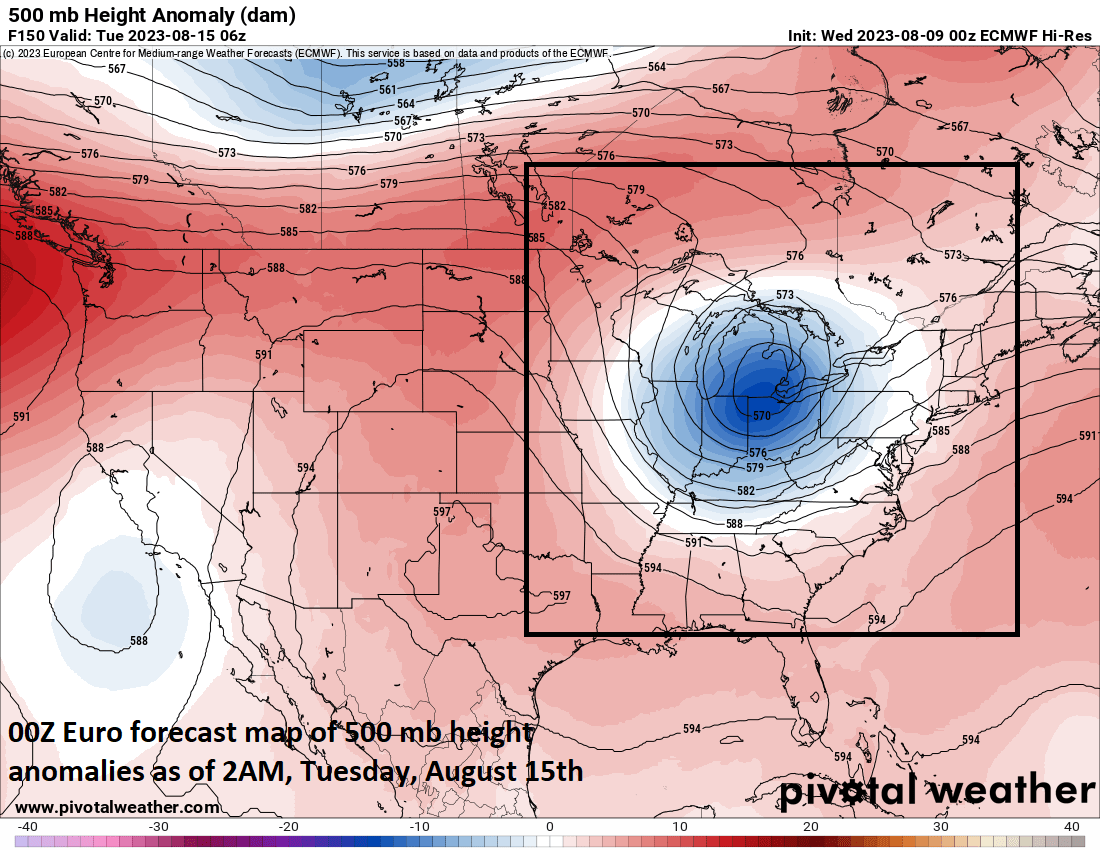
A vigorous wave at the 500 millibar level will cross the Great Lakes on Monday and this would enhance upward motion significantly in the Mid-Atlantic potentially leading the way to another round of severe weather for the region. Map courtesy ECMWF, Pivotal Weather
Overview
A widespread severe wind event rocked the Mid-Atlantic region this past Monday and a key ingredient was a vigorous wave of low pressure aloft that crossed the Great Lakes on a path towards the northern Mid-Atlantic. Other ingredients included multiple jet streaks in the atmosphere, a strong surface cool front, and an influx of very moist air from the southeastern states on the front side of the front. A similar overall weather pattern may repeat itself from later Monday into Monday night. While still several days away, many of these same factors may indeed come together early next week and the result can be another round of heavy showers and strong-to-severe thunderstorms for the Mid-Atlantic region.

Strong jet streaks at multiple levels of the atmosphere would also enhance upward motion significantly in the Mid-Atlantic region. Map of low-level streak (left) and upper-level jet streak (right) courtesy ECMWF, Pivotal Weather
Details
An active weather pattern across the northern US will continue for the next several days with multiple disturbances crossing from northwest-to-southeast through the base of a large-scale upper-level trough of low pressure. One such system will drop southeast on Thursday, August 10th, towards the Northeast US increasing the chance of PM showers and thunderstorms in the Mid-Atlantic region after a quiet and dry middle of the week. In fact, this next system is quite strong and will contribute to a severe weather outbreak later today across the Middle Mississippi and Tennessee Valleys. On Thursday, any rain that falls in the Mid-Atlantic region can be heavy at times and any thunderstorm can be strong-to-severe.
Following tomorrow’s system, a second and weaker disturbance will stay a bit farther to the north late Saturday producing some patchy clouds in the Mid-Atlantic region and a rather limited chances of showers. It is the third system in this series of disturbances that may be the strongest and it can drop farther to the south and east raising the chance of heavy showers and strong-to-severe thunderstorms in the Mid-Atlantic region early next week.

Bulk wind shear is likely to quite high across the northeastern quadrant of the country by late Monday night as depicted here by the 00Z Euro and this would increase the chances for severe thunderstorm activity. Map courtesy ECMWF, Pivotal Weather
By the time Monday afternoon rolls around, the weather maps could feature surface low pressure dropping southeast across the central Great Lakes with a cool front extending to the south from the storm center. Additionally, as was the case with this past Monday’s event, this surface system will have strong support aloft in the form of a vigorous 500 millibar low that is likely to drop southeast across the Great Lakes and into the northern Mid-Atlantic. Ahead of the incoming frontal system, a low-level flow of air from the south-to-southwest is likely to pump in high levels of moisture…another ingredient that can contribute to the destabilization of the atmosphere.

A strong vorticity max will cross the Great Lakes later Monday and this would enhance upward motion in the Mid-Atlantic region by Monday night which, in turn, would increase chances of strong-to-severe thunderstorm activity. Map courtesy ECMWF, Pivotal Weather
The bottom line…the Mid-Atlantic region can very well be facing a repeat performance next Monday/Monday night of last Monday’s weather situation which featured numerous heavy showers and strong-to-severe thunderstorms…stay tuned.
Meteorologist Paul Dorian
Arcfield
arcfieldweather.com
Follow us on Facebook, Twitter, YouTube
Extended video discussion on the upcoming severe weather threats as well as an update on current sea surface temperature anomalies and a sneak peek at the upcoming winter :