
9:45 AM | ***Hurricane Lee to take a turn to the north at mid-week…impacts eastern New England this weekend with heavy rain, strong winds…active overall tropical scene at climatological peak***
Paul Dorian

The climatological peak of the Atlantic Basin season here at mid-September features four systems including Hurricane Lee (category 3, frontrunner), Tropical Storm Margot (upper, center), and two additional systems in the far eastern Atlantic (lower, right). Images courtesy NOAA/GOES-East
Overview
The climatological peak of the Atlantic Basin tropical season is right around this time of year and it is certainly living up to its billing. Lee is a category 3 “major’ hurricane today and continues to move slowly on a west-northwest track over very warm waters of the tropical Atlantic Ocean. It will take a turn to the north later in the week as it becomes increasingly influenced by an upper-level trough that will build over the central and eastern states. Lee will likely have a significant impact on eastern New England this weekend with heavy rains and strong winds as it pushes towards Maine or Nova Scotia as a tropical storm or “post-tropical” system.
Elsewhere in the Atlantic Basin, Tropical Storm Margot may indeed reach hurricane status in the near-term; however, its future looks rather harmless as it likely stays over the open waters of the Atlantic Ocean. Another tropical system has just pushed off the west coast of Africa and is now located over the far eastern Atlantic. It is likely that this system intensifies in coming days and may ultimately present a threat to the US east coast sometime later this month.
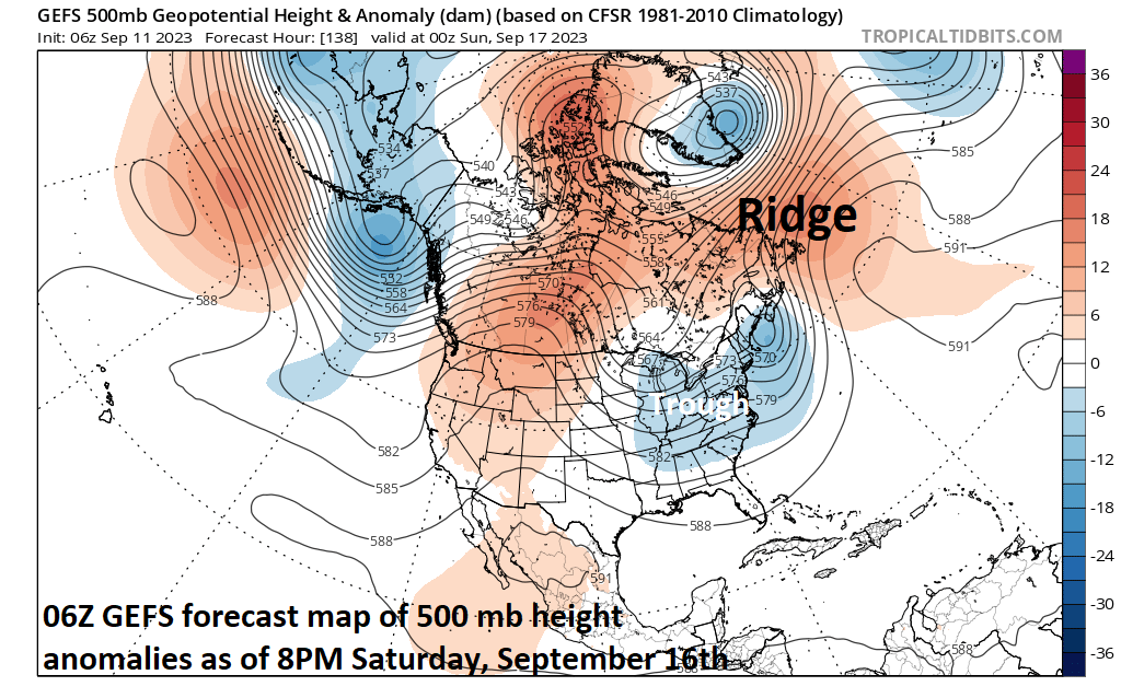
Two key players in the ultimate track of Hurricane Lee will be an upper-level trough that is to form over the central and eastern states later this week and an upper-level ridge that will intensify over eastern Canada and the NW Atlantic by the end of the week and early part of the weekend. The increasing influence of the trough over the central and eastern US will contribute to a turn to the north of Hurricane Lee at mid-week and the ridge over the NW Atlantic will likely prevent any kind of a harmless path for Lee out to the open waters of the North Atlantic. Map courtesy tropicaltidbits.com, NOAA
Details
Hurricane Lee has max sustained winds of 120 mph this morning and continues to move slowly (7 mph) on a northwest path as it is influenced by a nearby upper-level ridge. This slow trek on a general west-to-northwest path over very warm waters of the tropical Atlantic near 30 degrees (Celsius) will continue for another couple of days, but then a turn to the north will take place as Lee becomes increasingly influenced by a building upper-level trough of low pressure over the central and eastern states. This northward track should take Lee to the west of Bermuda later this week and it’ll begin to move over a “cool wake” left behind by the upwelling caused by the passage of Hurricane Franklin several days ago.

The mid-September climatological peak of the Atlantic Basin tropical season is living up to its billing this year with four systems to monitor as of Monday, September 11th. Map courtesy NOAA/NHC
By the late week, the upper-level trough over the central and eastern states will be joined on the stage by an intensifying upper-level ridge of high pressure over eastern Canada/NW Atlantic. This ridge will indeed play a critical role in the ultimate path of Lee as it will likely inhibit any chance for Lee to escape harmlessly out to the open waters of the North Atlantic. Instead, Lee may actually take a bit of a turn back to the northwest as it climbs to higher latitudes and this will increase chances for impacts on eastern New England by the late week and weekend with heavy rains and strong winds on the table.
It is important to note that an impact on eastern new England by Lee is quite likely whether or not there is a direct hit as its associated wind field is likely to spread out compared to current levels. All residents along the eastern New England coastline need to closely monitor Lee’s movement in coming days along with those in Nova Scotia (Canada). Given the movement of Lee over cooler waters of the western Atlantic later in the week, it is likely to weaken from current “major” hurricane levels; however, impact in eastern New England and Atlantic Canada can certainly still be significant. Lee is likely to approach Maine or Nova Scotia by the weekend as a tropical storm or a “post-tropical” system. As far as direct hurricane hits in New England are concerned, there has actually been a drought in recent decades. According to Meteorologist Joe Bastardi, New England was directly hit by a hurricane on average once every 6.7 years in the extended period from 1938-1991. There have be no direct hits of hurricanes in New England since 1991.
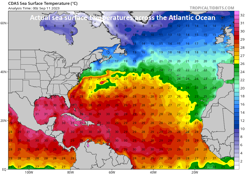
Hurricane Lee is now over very warm waters of the tropical Atlantic of around 30 degrees (Celsius). Later in the week, as it climbs to higher latitudes, Lee will travel over cooler waters left behind by upwelling caused by the passage of Hurricane Franklin several days ago. Map of actual sea surface temperatures courtesy tropicaltidbits.com, NOAA
Looking ahead, there is a new tropical system in the far eastern Atlantic Ocean that has the likelihood of intensifying in coming days as it treks across the tropical Atlantic Ocean. There are some signs that this system may ultimately pose a threat to the US, but that is all in the “speculation phase” right now and there are many days to go to iron out those details. One of the factors down the road for this next system may very well be a “cooled-off” area in the western Atlantic that could form in the wake of Hurricane Lee’s passage (i.e., upwelling).
The mid-September climatological peak of the Atlantic Basin season is certainly living up to its billing in 2023.

Climatological peak of the Atlantic Basin season is right around the middle of September and it is living up to its billing this year. Data courtesy NOAA
Meteorologist Paul Dorian
Arcfield
arcfieldweather.com
Follow us on Facebook, Twitter, YouTube
Video discussion: