
10:30 AM | **Storm threat along the east coast this weekend…system likely to take on tropical characteristics...strong onshore winds**
Paul Dorian

Low pressure should form just off the Southeast US coastline at week’s end and it will have a tropical connection. Tropical moisture will flow into this intensifying system to the southeast of the low pressure center. Combine this expected tropical moisture with Atlantic moisture (onshore winds) and the result may be quite a widespread and soaking rain event for much of the eastern US. Map courtesy Canadian Met Centre, tropicaltidbits.com
Overview
A storm threat exists for the weekend near or along the east coast with the potential of a widespread soaking rain event featuring persistent and strong onshore winds. Low pressure looks like it will form late this week just off the Southeast US coastline over very warm waters of the southwestern Atlantic and likely take on “tropical” characteristics. With high pressure expected to build to its north and east, this low pressure system should push northward right through the eastern states. Whether or not this system becomes classified as “tropical” remains to be seen; however, the end result could be the same with heavy rain and strong winds on the table.
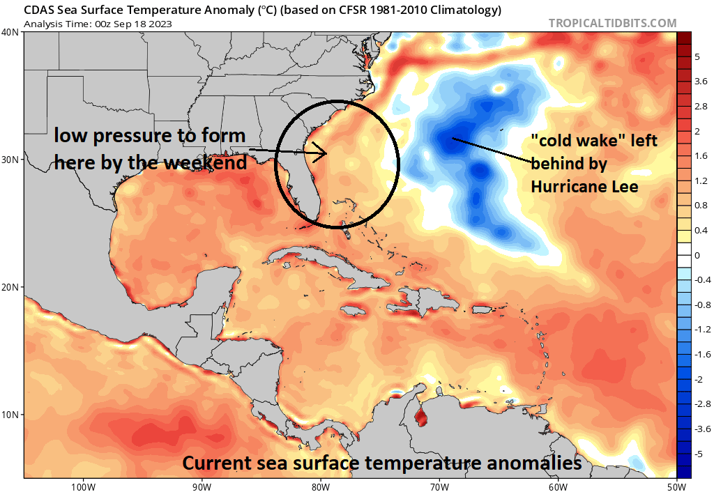
Sea surface temperatures are quite warm and above-normal just off the coastline of the Southeast US. Low pressure is likely to intensify in this region (circled) at week’s end and will likely take on “tropical” characteristics. Just to the east, there is a “cold wake” in the western Atlantic left behind by upwelling associated with the passage of Hurricane Lee. Map courtesy NOAA, tropicaltidbits.com
Details
Typically, the latter half of the Atlantic Basin tropical season features more in the way of “home-grown” tropical systems rather than the “long-tracking” African waves such as what took place just recently with Hurricane Lee. These “home-grown” tropical systems can form closer to the US in the Gulf of Mexico, Caribbean Sea or southwestern Atlantic where sea surface temperatures remain very warm. Indeed, the late week and weekend may feature such a “home-grown” type system that forms over the abnormally warm waters of the SW Atlantic just off the Southeast US coastline. Whether or not this system is ultimately officially deemed “tropical” remains to be seen; however, it should take on tropical characteristics as it is likely to spend a decent amount of time out over the warm waters of the SW Atlantic.

High pressure ridging centered over southeastern Canada will play a big role this weekend in a couple of ways. First, it will contribute to an intensifying pressure gradient between the high to the north and the low to the south which will, in turn, lead to strengthening onshore winds. Second, this ridge will combine with additional ridging over the western Atlantic to influence the storm to push northward through the eastern states instead of taking an “out-to-sea” path. Map courtesy Canadian Met Centre, tropicaltidbits.com
As the weekend gets underway, strong high pressure at the surface will build across New England and upper-level ridging will intensify across southeastern Canada and the western Atlantic. As a result, low pressure that forms just off the Southeast US coast line is quite unlikely to push out-to-sea, but instead will be influenced by the high pressure to the north and east to ride up along or near the eastern seaboard. The difference in pressure between the high pressure over New England and the intensifying low pressure system will tighten and this will raise the possibility of strong onshore winds from the Carolinas to the Mid-Atlantic. Rainfall may become rather widespread and soaking in nature for much of the eastern US given the influx of tropical moisture as the storm gets going off the SE US coastline and the Atlantic moisture that’ll increase with strengthening onshore winds.
Meteorologist Paul Dorian
Arcfield
arcfieldweather.com
Follow us on Facebook, Twitter, YouTube
Video discussion: