
12:30 PM | ***Tropical Storm Lee very likely to reach “major” hurricane status as it treks across the tropical Atlantic Ocean...“category 5” classification is on the table***
Paul Dorian

Tropical Storm Lee is on the verge of becoming a category 1 hurricane and is very likely to attain “major” hurricane status of category 3 or higher by the weekend. In fact, there is a chance that Lee climbs all the way to category 5 classification by later this weekend or early next week. Images courtesy NOAA/NESDIS
Overview
Tropical Storm Lee is on the door step of “category 1” hurricane classification and all indications are that it will continue to intensify and reach “major” hurricane status by the weekend. In fact, the expected significant intensification of Lee could result in the storm climbing all the way to “category 5” classification sometime this weekend or early next week. The overall environment becomes very favorable for the strengthening of Lee with a relaxation of wind shear and a west-to-northwest trek over very warm waters of the tropical Atlantic. By early next week, the west-to-northwest path of Lee could change to a northerly direction which would reduce the chances of a direct impact on the US east coast. However, two systems that will likely dictate the ultimate storm track of Lee are many days away from even forming. They include an upper-level trough that may form over the Ohio valley/eastern US and upper-level ridge that may intensify over southeastern Canada/NW Atlantic. It is simply too early to say how this upper air pattern will unfold; therefore, too early to say if Lee can indeed directly impact the US east coast.

There is general agreement amongst computer forecast models that TS Lee will trek to the west-northwest during the next few days which will take it on a path to the north of the northern Leeward Islands. Lee may then turn to the north, but exactly where this “turn point” takes place can have big implications downstream. Map courtesy ECMWF (00Z Euro ensemble member projected storm tracks of Lee)
Details
Tropical Storm Lee features maximum sustained winds of 70 mph at mid-day which is about double the intensity of 24 hours ago. It is pushing west-to-northwest at around 14 mph under the influence of a central Atlantic Ocean ridge and that directional movement should be consistent over the next few days. The strengthening of Lee during the next 48 hours or so will likely be somewhat gradual as it encounters some wind shear (east-to-northeasterly). Rapid intensification is possible on Friday night and during the weekend as it travels over abnormally warm waters of nearly 30 degrees (C) and directly underneath an upper-level ridge of high pressure. This ridge will result in low wind shear – a very favorable ingredient for tropical cyclone intensification – and Lee could not only reach “major” hurricane status of “category 3”, but could actually strengthen all the way to a “category 5” classification by early next week.

In addition to a relaxation of wind shear, another factor very favorable for intensification of Lee in coming days will be the movement over abnormally warm waters of the tropical Atlantic. Interestingly, once Lee turns to the north and climbs to higher latitudes, it is likely to ride over a “cold wake” in the western Atlantic that was left behind by the passage last week of Hurricane Franklin (upwelling). Map courtesy NOAA, tropicaltidbits.com
After that, the west-to-northwest track of Lee could begin to change to more of a northerly direction. Interestingly, this change in direction and climb to higher latitudes could actually result in Lee moving over a “cold wake” left behind by the passage of Hurricane Franklin last week (upwelling). The potential turning of Lee would be the result of a change in steering currents from the influence of the upper-level ridge (WNW direction) to the influence of an incoming trough of low pressure (N direction). The timing of this potential turning of Lee is somewhat uncertain and what happens at a “turn point” can have big implications downstream.
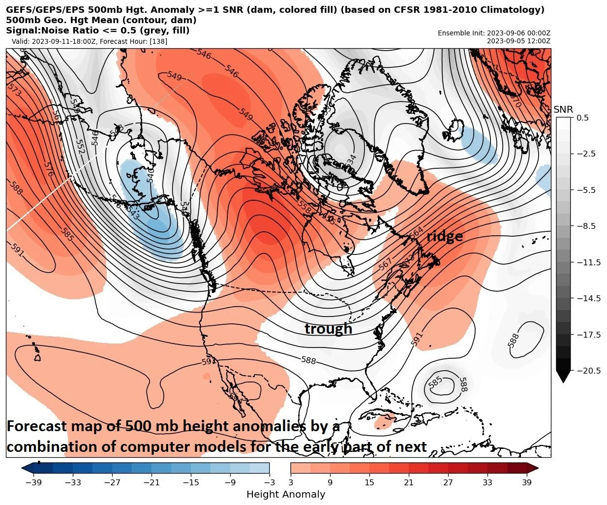
Two key players that are expected to be on the scene later next week will be a ridge of high pressure that is expected to form over SE Canada/NW Atlantic and a trough of low pressure that may form over the Ohio Valley/eastern US. It is a bit too early to determine which of these two systems will dominate and have the most influence on the ultimate track of Lee. Map provided by Michael Barletta (Twitter), courtesy NOAA, Canadian Met Centre, ECMWF
The two big players in the upper atmosphere that can ultimately dictate where Lee will move include a trough of low pressure that is likely to form over the Ohio Valley/eastern US later next week and a ridge of high pressure that may develop over southeastern Canada/NW Atlantic. If the ridge over SE Canada/NW Atlantic becomes the dominating system then Lee could end up going farther to the west - potentially resulting in a direct impact somewhere along the US east coast. If the trough over the Ohio Valley/eastern US comes in stronger or quicker, it could help steer Lee to the north and northeast - before it ever reaches the US east coast.
Current model forecast projections tend to favor a curving of Lee to the north - before it ever reaches the US east coast. However, there are some recent signs that point to an intensification of the ridge over SE Canada/NW Atlantic that raises a cautionary red flag about a possible trek of Lee farther to the west. Two recent examples of hurricanes that were projected to curve away from the US east coast at this vantage point - and ultimately did not - include Florence in 2018 which ended up pounding away at the Carolinas with tremendous amounts of rainfall and Irma in 2017 which eventually significantly impacted places as far to the south and west as Key West, Florida.
For now, all interests along the US east and Gulf coasts (and in the Bahamas) should keep a close eye on Lee as it continues on a “long track” across the tropical Atlantic Ocean and likely reaches “major” hurricane status…perhaps even a “cat 5”. One final note, there is a trailing tropical wave over the far eastern Atlantic and it is quite likely to also reach named tropical storm status in coming days (would be named Margot).
Meteorologist Paul Dorian
Arcfield
arcfieldweather.com
Follow us on Facebook, Twitter, YouTube
Video discussion: