
11:15 AM | **Milder pattern sets up across the Mid-Atlantic/NE US, but it doesn’t come without wintry threats…a very wet stretch in the Miss. Valley...a stormy couple of weeks for the west coast**
Paul Dorian

Freezing rain is on the table for late Tuesday night across much of PA and northern NJ. In fact, there can be some freezing rain all the way down to the nearby suburbs to the north and west of Philly and NYC by early Wednesday and perhaps even to the far N/W suburbs of DC.. Map courtesy Canadian Met Centre, Pivotal Weather
Overview
The 7-day period from 14 January to 20 January was very cold across most of the nation with the mean temperature anomaly of -11°F in the Lower 48. The next 7-days will be quite a different story as a milder weather pattern develops for much of the country. This warm-up, however, will not come without wintry threats in the Mid-Atlantic region and Northeast US. The change in the overall pattern will bring copious amounts of rainfall for the Lower Mississippi Valley region in the near-term and plenty of moisture-filled storm systems for the US west coast during the next couple of weeks.
In the near term, there is likely to be some freezing rain from later Tuesday night into early Wednesday across much of Pennsylvania and northern New Jersey and maybe all the way into the nearby N/W suburbs of Philly and NYC and the far N/W suburbs of DC. It does turn wet and milder in the Mid-Atlantic region during the second half of the week with the warmest day likely to be on Friday when temperatures will surge. Another storm system is then likely to impact the Mid-Atlantic/Northeast US late in the upcoming weekend with one surface low pressure system (primary) heading into the Ohio Valley and a secondary likely to form near the Mid-Atlantic coastline. While there will be little cold air around initially, strong high pressure will build into southeastern Canada and act as a cold air source…possibly resulting in a changeover from rain-to-snow across interior sections of the Mid-Atlantic/Northeast US. Looking ahead, there are signs that an overall colder weather pattern may re-develop in the central and eastern states as we progress through the early part of February and towards the middle of next month.

The 7-day period from 14 January to 20 January was very cold indeed across much of the nation with temperatures averaging more than 11 degrees (F) below-normal. Map courtesy NOAA, weathermodels.com
Near-term
Arctic air has dominated the scene across the central and eastern US in recent days causing well below-normal temperatures in what is climatologically-speaking just about the coldest time of the winter season. Early Monday morning, there were single digit temperatures in places like interior New Jersey and 7 degrees was recorded at Dulles Airport in Virginia near the nation’s capitol. The conditions were just right on Sunday night for significant radiationally cooling in the Mid-Atlantic region as very strong Canadian-born high pressure was positioned overhead and right on top of a still relatively fresh snow cover.
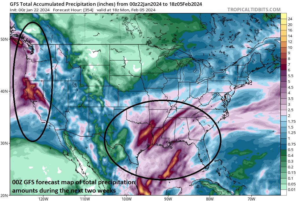
This extended forecast map of total precipitation amounts during the next two weeks highlights two parts of the country. First, the Mississippi Valley will get hit hard with rainfall in the near-term and second, the US west coast is liable to get hit hard with multiple storm systems during the next couple of weeks. Map courtesy NOAA, tropicaltidbits.com
This strong high pressure system will push off the eastern seaboard on Tuesday at the same time another one pushes into southeastern Canada. Meanwhile, moisture will push northeastward on Tuesday from the Gulf of Mexico and into the northern Ohio Valley and then it takes a turn to the east later Tuesday night and into the Mid-Atlantic region and Northeast US. Given the snow cover and strong high pressure system that will form over southeastern Canada, there is likely to be enough low-level cold air in place for some accumulating snow across interior sections of the Northeast e.g., northern PA, New York State) and freezing rain will be possible across much of central Pennsylvania and northern New Jersey heading into Wednesday morning. In fact, there is a chance that some freezing rain develops all the way down into the nearby north and wester suburbs of Philadelphia and New York City from late Tuesday night into early Wednesday and perhaps even into some of the far N/W suburbs of DC.
By later Wednesday and during the days on Thursday and Friday, it should become warm enough for plain rain to fall throughout most of the Mid-Atlantic region and Northeast US. The warm up during the second half of the week will likely peak on Friday afternoon in the DC-to-Philly-to-NYC corridor with temperatures spiking to the middle 60’s in DC, near 60 in Philly, and the middle 50’s in NYC.
One other note, this developing pattern of moisture flowing northeastward from the Gulf of Mexico into the eastern states will result in copious amounts of rainfall for the Lower Mississippi Valley during the next 5 days or so. In states like Louisiana, this week’s rainfall may be quite welcome as it has been very dry there in recent weeks.

A storm system is likely to impact the Mid-Atlantic/NE US late in the upcoming weekend with a primary low heading into the Ohio Valley and a secondary forming off the Mid-Atlantic coastline. While there will be little in the way of true cold air around initially, a developing strong high pressure system across SE Canada could help provide enough for an eventual changeover from rain-to-snow in some interior sections of the Mid-Atlantic/NE US. Map courtesy NOAA, tropicaltidbits.com
Late weekend threat
The weekend does begin on the mild side in the Mid-Atlantic region, but it turns somewhat colder by the second half. A storm system is likely to impact the Mid-Atlantic/NE US by late in the upcoming weekend with a primary low pressure system heading into the Ohio Valley and a secondary forming just off the Mid-Atlantic coastline. While there will be little in the way of true cold air around initially, a developing strong high pressure system across SE Canada could eventually help to provide enough for an ultimate changeover from rain-to-snow across some interior sections of the Mid-Atlantic/NE US.…something to monitor in coming days.

Longer range forecast map of 500 mb height anomalies suggest a colder and stormier pattern may return to the central and eastern states during the early-to-mid February time period. Map courtesy ECMWF, Weather Bell Analytics
Early-to-mid February
Looking beyond the weekend, there are signs that a colder weather pattern may re-emerge across the central and eastern states as we push through the early part of February and towards the middle of the month. High-latitude ridging will likely set up again across Canada and upper-level troughing is likely to return to the central and eastern states – both of which favor a return to colder-than-normal conditions.

The teleconnection index known as the Arctic Oscillation is likely to drop into “negative” territory in coming days which is usually a sign of higher heights-than-normal across Canada which, in turn, often favors colder weather in the central and eastern US. Map courtesy NOAA, Weather Bell Analytics (Joe Bastardi, Twitter)
Support for this kind of pattern change back to colder-than-normal again in the central and eastern US is based on a couple of areas. First, there was a recent stratospheric warming event that often results in an impact to US temperatures several weeks later and, in this case, that would be from later in February into the month of March. Second, a teleconnection index known as the Arctic Oscillation is forecasted to drop from positive-to-negative territory during the next couple of weeks suggesting higher heights are to build across Canada. A closely related teleconnection index known as the North Atlantic Oscillation (NAO) has the same trend forecasted in the near-term going from positive-to-negative territory.
One final note, this evolving weather pattern over the next couple of weeks is likely to bring about multiple storm system to the US west coast from California to Washington. No doubt we will hear the phrase “atmospheric river” quite often during this stormy stretch as, indeed, there will be a consistent west-to-east strong jet stream over the Pacific Ocean that will flood the west coast with moisture in coming days. Expect to see several inches of rain in lower elevations of the western states during these next couple of weeks and plenty of snow in the higher elevations (e.g., Sierra Nevada Mountains).
Meteorologist Paul Dorian
Arcfield
arcfieldweather.com
Follow us on Facebook, Twitter, YouTube
Video discussion: