
1:15 PM | ****Heavy rain, powerful winds in the Mid-Atlantic/NE US…flooding and numerous power outages on the table…a second powerful storm at week’s end…some intense cold****
Paul Dorian

A powerful low-level jet streak will enhance the chance for damaging wind gusts later today and tonight across the Mid-Atlantic/NE US. Winds can gust as high as 55-60 mph along the interior sections of the I-95 corridor (e.g., DC, Philly) and 65+ mph along coastal sections from the Delmarva Peninsula to New England….unfortunately, widespread power outages are on the table. Map courtesy NOAA, tropicaltidbits.com
Overview
A powerful storm system will bring heavy rainfall and increasingly strong winds to the Mid-Atlantic region and Northeast US this afternoon and tonight leading to localized flooding and unfortunately, numerous power outages are on the table. The grounds are well-saturated from recent heavy rain events and today’s storm can add another 2 or 3 inches with isolated higher amounts possible. Winds can gust to 55 or 60 mph along the interior sections of the I-95 corridor with even higher amounts along coastal sections of the Mid-Atlantic and Northeast US. As a result, trees, limbs and power lines will be quite vulnerable leading to the fear that power outages can become widespread.
Another powerful storm system can bring heavy rain and strong winds to the Mid-Atlantic region and Northeast US on Friday night and this second system will usher in much colder air for the latter part of the weekend and early part of next week. In fact, there will be some intense cold this weekend dropping southward from Canada into the US and some of this air will trek south and east reaching the eastern seaboard later in the weekend. A third storm system threatens the eastern states early-to-mid next week and this time snow will be on the table in the I-95 corridor given the expected preceding influx of Arctic air.

Accumulating snow falls today from powerhouse storm system #1 across portions of the Upper Midwest and Great Lakes with heavy rainfall in the Mid-Atlantic/NE US. Map courtesy NOAA, tropicaltidbits.com
Heavy rain and damaging wind gusts from storm system #1
Low pressure is intensifying over the Upper Midwest today and is producing rain in the Mid-Atlantic region with snow falling across interior, higher elevation sections of the Northeast US. The rain will become heavy this afternoon and continue tonight in the DC-to-Philly-to-NYC corridor with as much as 2-3 inches possible by early Wednesday morning. As a result, localized flooding is a high risk given the already very well saturated grounds from recent heavy rain events.
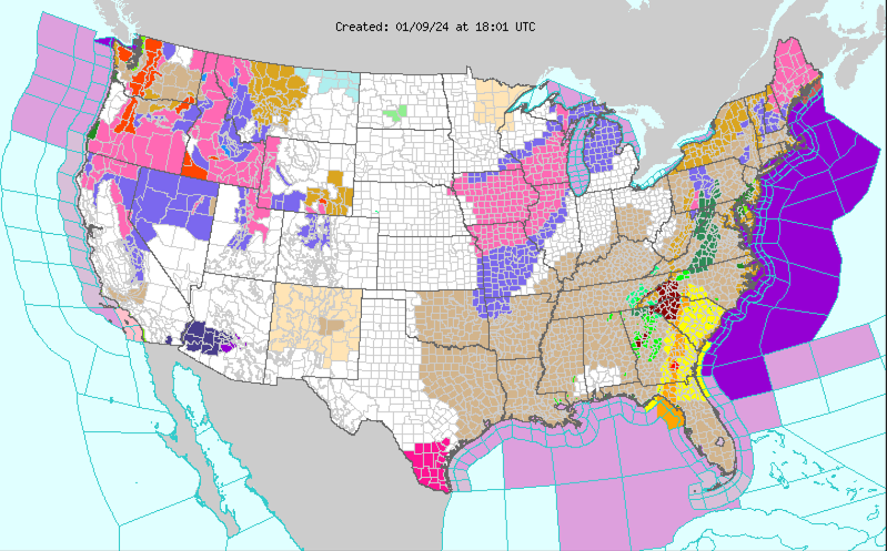
It’s never good when you see all of these colors on NOAA’s “Weather Warnings Map”. Today’s myriad of colors are due to such weather threats as tornadoes (yellow), winter storm(s) (pink, purple) and flash flooding (green). Map courtesy NOAA/WPC
In addition to the heavy rainfall, a major factor during this storm will be the winds which will become quite strong later in the day and damaging wind gusts are possible tonight on the order of 55-60 mph in the interior sections of the I-95 corridor (e.g., DC, Philly) and 65+ mph along coastal sections of the Mid-Atlantic/Northeast US. Winds later today and tonight will be from an east-to-southeast direction (onshore) adding to the potential of coastal flooding from the Delmarva Peninsula to New England. Given the very wet grounds throughout the northeastern states, these strong winds may knock down tree limbs and power lines and some trees may be quite vulnerable with soaked (and possibly weakened) root systems. On the back side of the storm, winds on Wednesday will remain strong in the Mid-Atlantic region though not quite as powerful as what can be expected late today and tonight. The wind direction will shift on Wednesday to generally a west-to-southwest direction in the Mid-Atlantic region and gusts can reach 40 mph.

Accumulating snow falls from powerhouse storm system #2 at week’s end across portions of the Upper Midwest and Great Lakes with heavy rain again likely in the Mid-Atlantic/NE US. Map courtesy NOAA, tropicaltidbits.com
Second powerhouse storm system at week’s end/weekend
Another powerhouse storm system will impact a wide part of the nation at week’s end and into the upcoming weekend. In fact, this second system may meet the qualifications of a “bomb cyclone” - rare over land - which is defined as having its central pressure drop by at least 24 millibars in a 24-hour period. Some computer forecast model runs have the lowest pressure of this storm bottoming out as low as 962 millibars which is 28.41 inches and quite rare for this part of the world.
This second storm system will have more in the way of Arctic air to work with and the result may be an all-out blizzard for sections of the Midwest including such states as Michigan, Illinois and Indiana. In the east, “mild” air will again surge northward out ahead of the surface low leading to the possibility of more flooding rainfall. Winds will again become quite strong in the Mid-Atlantic/NE US at the end of the week and extreme winds are possible across the Midwest/Great Lakes into the early part of the weekend with lake-effect snows to boot in those areas just downstream of the still relatively warm and unfrozen lakes. The passage of the weekend storm system will usher in much colder air for the Mid-Atlantic/Northeast US and there could be another (third) storm system to deal with in the eastern states during the first half of next week and this time snow will likely be on the table for the I-95 corridor….more on that later this week.
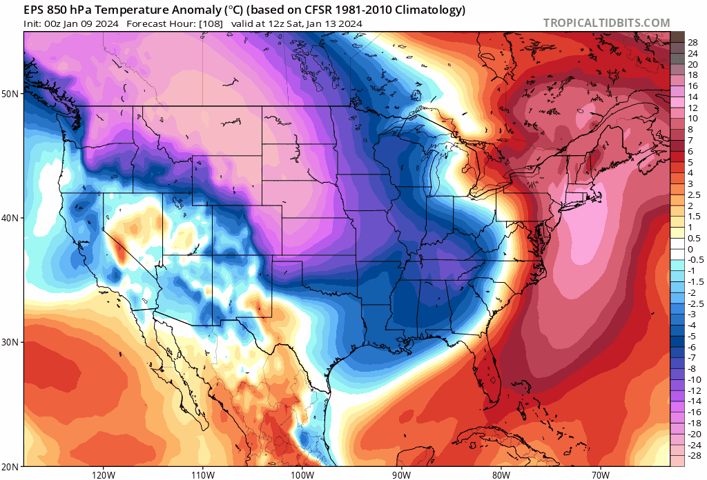
Intense cold will work its way south and east from Canada and into the US later in the week and it’ll turn much colder in the eastern states later this weekend on the heels of storm system #2. Maps courtesy ECMWF, tropicaltidbits.com (00Z EPS 850 temperature anomaly forecast maps extend from 7AM Saturday, January 13th to 7AM, Wednesday, January 17th)
Intense cold
A stratospheric warming event that began in late November has contributed to the unleashing of some brutally cold air masses into the middle and high latitudes from the polar region. A few weeks ago, China, North and South Korea recorded some of their lowest temperatures in decades and just in the last week, Scandinavian countries of Sweden, Denmark and Finland have seen some of their coldest temperatures since last century.

Intense cold is possible in about a week’s time across the Mississippi Valley/Midwest/Tennessee Valley as depicted here for next Tuesday, January 16th (forecast map of actual 2-meter temperatures). Map courtesy ECMWF, Weather Bell Analytics
There continue to be strong signs that intense cold air will make its way onto this side of the North Pole and into the US later this week dropping southward from western Canada. In fact, recent forecast model runs show some intense cold air reaching the middle Mississippi and Tennessee Valleys in about a week’s time with temperatures some 50 degrees below-normal for this time of year.
Buckle up…lots of action in the weather department during the next week to ten days.
Meteorologist Paul Dorian
Arcfield
arcfieldweather.com
Follow us on Facebook, Twitter, YouTube
Video discussion: