11:00 AM | ***An update on the tropical system over the Caribbean Sea (and there is some good news for the Gulf coast)...an early preview of winter coming to the central/eastern US***
Paul Dorian
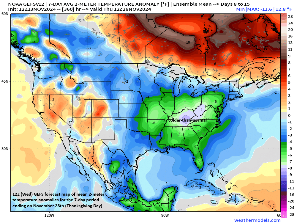
Colder-than-normal conditions (shown in green) are likely on average across much of the central and eastern US from later next week through Thanksgiving week. Map courtesy NOAA, weathermodels.com
Overview
It is not all that unusual for the “last hurrah” of an Atlantic Basin tropical season to be followed by an influx of winter-like cold into the central and eastern US and, in some cases, it is a “pattern-changing” type of event. One such example of this kind of scenario unfolded with Hurricane Sandy at the end of October during 2012 which was then followed by a colder-than-normal month of November in almost all areas east of the Mississippi River. (In fact, cold air not only followed Hurricane Sandy, but actually wrapped into it with as much as 3 feet of snow piling up in portions of West Virginia during that event). It appears that this tropical season may finally wind down after the ultimate demise of the latest system now over the Caribbean Sea and cold air intrusions into the central and eastern may become much more commonplace beginning late next week. The tropical system is likely to intensify into a named tropical storm (“Sara”) in the near-term, but an extended time period over land will likely reduce its potential impact on the US Gulf coast.
Hurricane Sandy became a “pattern-changing” weather event in 2012 as its passage in late October was followed by sustained colder-than-normal conditions in much of the eastern third of the nation during the following month of November. Map courtesy NOAA
Tropical activity in the Caribbean Sea
In this Atlantic Basin tropical season that is having a hard time winding down, yet another system has formed over the still quite warm waters of the western Caribbean Sea. This system may intensify into a named tropical storm during the next day or two (would be “Sara”) and then it likely slows down and skirts the northern coastline of Honduras before pushing over Belize and the Yucatan Peninsula region of Mexico by the early part of next week. With the likely slowing down of the tropical season and potential extended time over land, rainfall amounts can become quite significant across portions of Central America such as in Honduras. In addition, with the extended time over land, intensification beyond tropical storm status is unlikely and it very well could weaken back to tropical depression status as what remains of the system finally enter over the southern Gulf of Mexico later next week.
The latest forecast map by NOAA’s National Hurricane Center of the tropical system over the western Caribbean Sea moves it slowly to a position near the northern coast of Honduras and then ultimately to the Yucatan Peninsula region of Mexico. This encounter with land in the near-term will limit the intensification of the tropical system before it likely spills out over the southern Gulf of Mexico later next week. Map courtesy NOAA/NHC
The likely limitation on intensification of this tropical system in the near-term is a very good thing for Florida since the likely path once it reaches the Gulf of Mexico will be to the northeast - and potentially right towards Florida’s Panhandle/Gulf coast. That is not to say that impact by this system will be necessarily on the low side along the US Gulf coast, but it is certainly positive news that it should be in a weakened state upon entering the southern Gulf of Mexico. The expected turn to the northeast of this system once out over the Gulf of Mexico will come about as an upper-level trough of low pressure intensifies over the central US. Southwesterly flow aloft on the trough’s southeastern flank will help steer the tropical system to the northeast. Once the tropical system pushes to a position out over the western Atlantic Ocean later next week, the door will be opened for cold air masses from Canada to make their way southeastward all the way into the eastern states beginning as early as late next week and this pattern change to colder-than-normal may last right to the end of November.
High-latitude blocking (shown in orange) will set up late next week over northern Canada and Greenland at the same time an upper-level trough intensifies over the central/eastern US. This is a wintry looking pattern that will likely feature colder-than-normal conditions across much of the eastern half of the nation and snow will no doubt be a possibility in some areas such as the Great Lakes, Ohio Valley and Appalachian Mountains. Map courtesy NOAA, Weather Bell Analytics
Pattern change to bring multiple cold shots to the central/eastern US
As what may be the last of the tropical systems this season pushes towards Florida and then the western Atlantic Ocean next week, high pressure will be intensifying over northern Canada and Greenland (high-latitude blocking). Also, an upper-level trough of low pressure will deepen markedly as it slides southeastward to the Ohio Valley/Mid-Atlantic by later next week and with it, much colder-than-normal air will bring a wintry chilly to central states. By late next week, this colder-than-normal air mass will likely reach the eastern states and there are likely to be reinforcing shots of cold air during the subsequent weekend and perhaps right through all of Thanksgiving week.
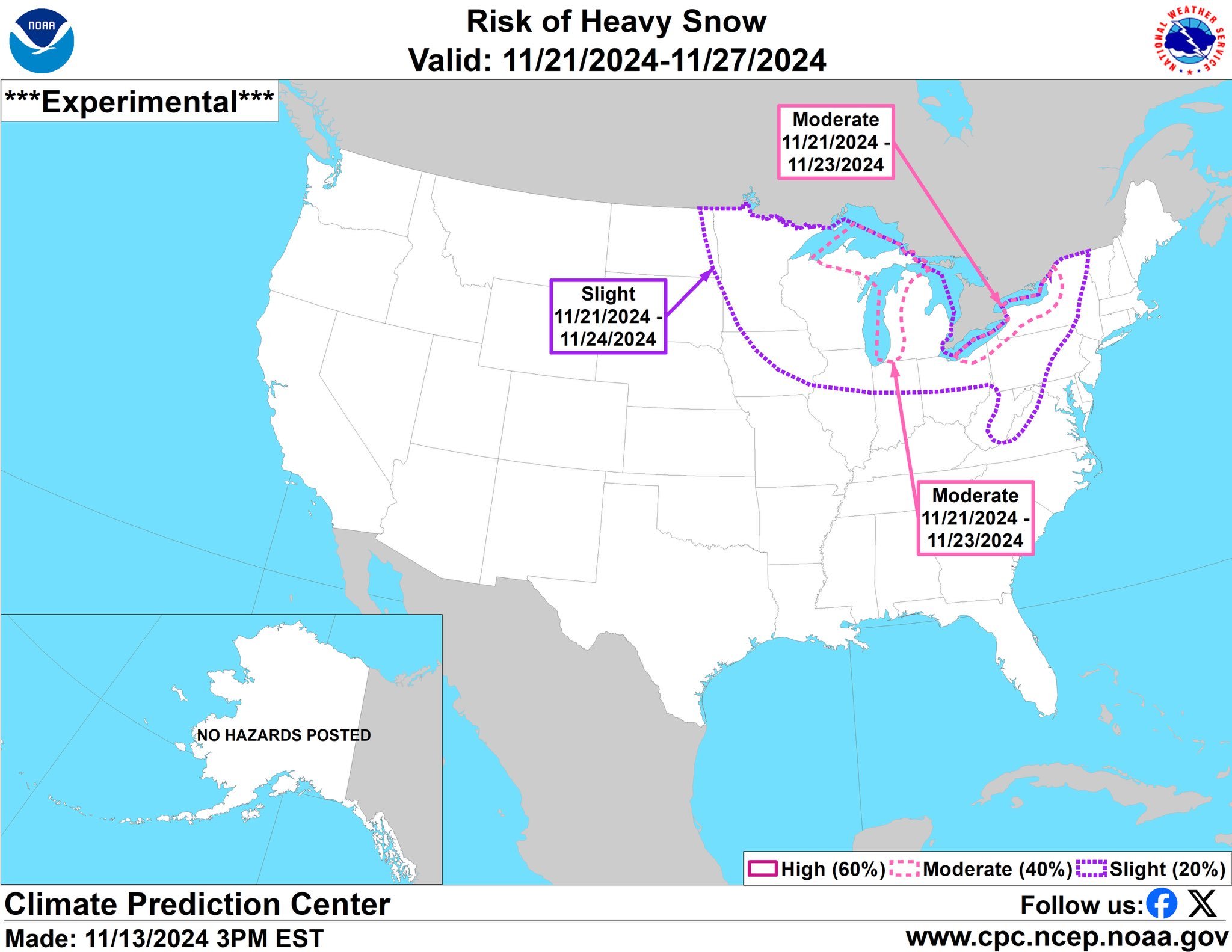
As the overall weather pattern changes to colder-than-normal in the central and eastern US from later next week through the end of November, the risk of snow will rise in some areas. One such area of concern for accumulating snow will be the Great Lakes with the likely scenario by late next week of cold air rushing over the still relatively warm lake waters creating unstable atmospheric conditions. Map courtesy NOAA
In terms of snow potential, odds are high that accumulating snow accompanies this upcoming pattern change across at least some portions of the central and eastern US. The Great Lakes, for example, could feature some significant “lake effect” snows late next week given the fact that the lake waters are still relatively warm which would set the stage for high instability in the atmosphere as cold air crosses overhead. In addition, there are signs that portions of the Ohio Valley and Appalachian Mountains can receive some accumulating snow late next week as the strong upper-level trough generates surface low pressure near the Northeast US coastline...stay tuned, odds are increasing for an early preview of winter in parts of the central and eastern US.
Meteorologist Paul Dorian
Arcfield
arcfieldweather.com
Follow us on Facebook, Twitter, YouTube
Video discussion:


