
12:00 PM | *Pattern change to colder-than-normal begins next week across the central and eastern US and it will have some staying power…storm threat at front-end of the transition*
Paul Dorian

A big time flip is coming to the temperature pattern across the US with above-normal conditions of the current 5 days (left) flipping to colder-than-normal in days 10-14 (Feb 15 to Feb 20, right). Maps courtesy NOAA, tropicaltidbits.com
Overview
Temperatures will be well above-normal in the central US during the next couple of days and this warm-up will extend to the eastern US this Friday and Saturday. However, a pattern change to colder-than-normal weather begins next week in the central and eastern US and this change looks like it will have some staying power. Numerous teleconnection indices point to a significant change in the overall pattern that indeed could last into March and recurring stratospheric warming supports the idea. As far as storm threats are concerned, signs are increasing for low pressure to push into the Mid-Atlantic region early next week on the front-end of this pattern transition. While there will be no cold air established on the front-end, it is possible that cold air can get wrapped into the system depending on its track so accumulating snow cannot be ruled out.
Remainder of this week
Temperatures will climb to well above-normal levels across much of the central US during the next couple of days on the back side of high pressure and this mild air mass will shift to the eastern states for Friday and Saturday. In fact, temperatures on Saturday afternoon can peak in the upper 50’s-to-middle 60’s in the DC-to-Philly-to-NYC corridor ahead of an incoming cold front. However, that cold frontal passage will begin a transition to colder weather conditions in much of the eastern half of the nation that may very well have some staying power.

The Madden-Julian Oscillation (MJO) index will rotate into a colder phase (8) later this month usually indicative of a change to colder across the central and eastern US. Plot courtesy NOAA
Teleconnection indices
A look at the teleconnection index known as the Madden-Julian-Oscillation or MJO which tracks a tropical disturbance indicates it will transition to “phases” which are normally associated with colder conditions across the eastern and southern US. The MJO is the major fluctuation in tropical weather on weekly-to-monthly timescales and can be characterized as an eastward moving “pulse” of clouds and rainfall near the equator that typically recurs every 30-to-60 days. The MJO phase diagram illustrates the MJO index through different phases which generally coincides with locations along the equator around the globe. When the MJO index is within the center circle, it is considered weak and when it is outside, it is stronger and usually moves in a counter-clockwise direction. The different phases of the MJO correlate well with different temperature and precipitation patterns around the world depending on the time of year. The current forecast of the MJO suggests it will propagate into the “colder” phase of 8 later this month which usually results in colder-than-normal weather across much of the central and eastern US.

The Arctic Oscillation (AO) teleconnection index is predicted to drop well into negative territory in the near-term and this is often correlated with the formation of a “high-latitude blocking” type of pattern. Plot courtesy NOAA
Other teleconnection indices known as the Eastern Pacific Oscillation (EPO), Pacific North America (PNA), Arctic Oscillation (AO) and North Atlantic Oscillation (NAO) are trending in directions that generally support the idea of sustained colder-than normal temperatures during the middle and latter parts of February and perhaps even well into March. Specifically, a pattern that features -EPO, +PNA, -AO and -NAO usually results in high pressure ridging across Alaska and the west coasts of the US and Canada and high-latitude “blocking” across northern Canada and Greenland…all of which tends to be favorable for cold air outbreaks to make their way from Canada into the central and eastern US.

Yet another burst of stratospheric warming is likely to take place in the polar region during the next ten days or so. Currently, the polar vortex is in a rather conventional location over the North Pole (left), but ten days into the future (right), it is displaced away from the pole as an area of warming aloft pushes arrives. Maps courtesy NOAA
Stratospheric warming
Additional support for a pattern change to colder-than-normal for the central and eastern US - and one with some staying power - comes from an on-going stratospheric warming event over the polar region of the northern hemisphere. This recurring stratospheric warming has already disrupted the polar vortex twice this winter season and it looks like it will do so again.

The upper air pattern featuring high-latitude blocking near Greenland and an eastern US trough of low pressure is predicted to begin by later next week and this particular model forecast suggests something similar could last all the way into mid-March. In other words, the colder-than-normal pattern that sets up next week across the central and eastern US could indeed have some staying power. Map courtesy NOAA, weathermodels.com
There was one spike in temperatures aloft that lasted from late November into mid-December, a second burst during the early and middle parts of January, and a third warming episode is looking likely during the next ten days or so. It is the second spurt of stratospheric warming that supports the notion of a pattern change to colder-than-normal beginning around the middle of February across the central and eastern US as there is usually a lag time of several weeks (4-6) for an impact on temperature patterns across the US. A third surge of stratospheric warming in the near-term can play a role in extending a colder-than-normal pattern well into the month of March given the 4-6 week time lag.
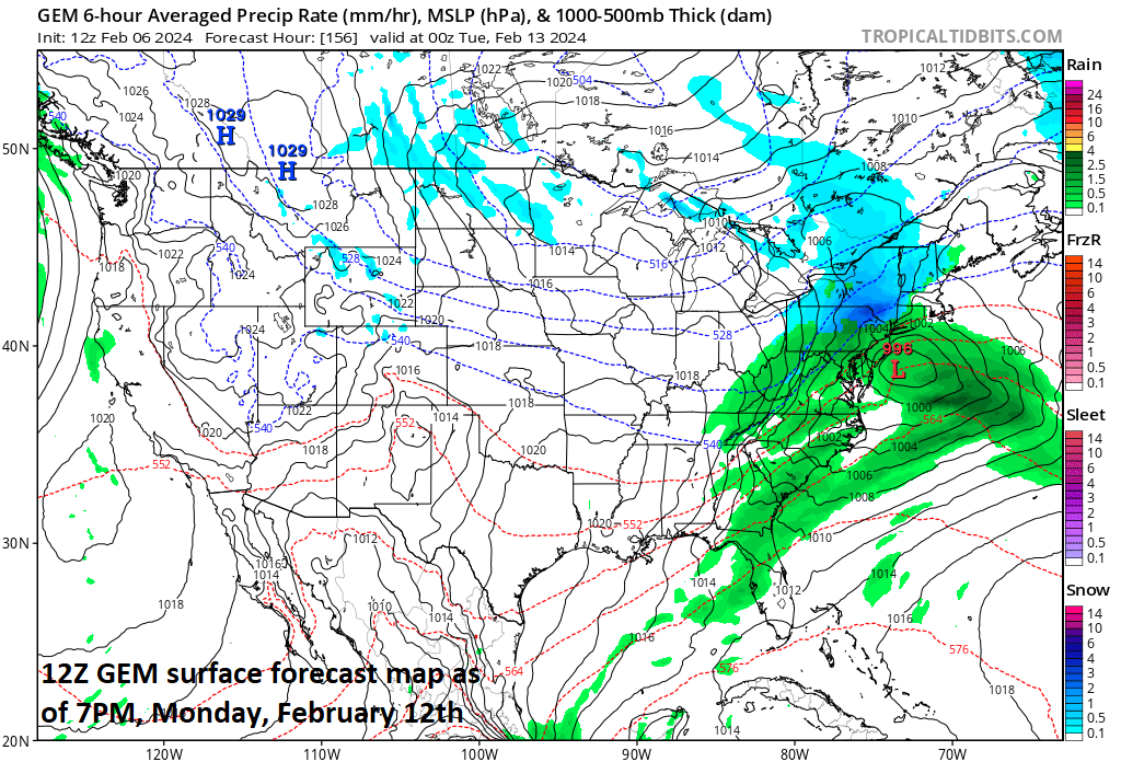
The front-end of the transition to a colder pattern early next week may be accompanied by low pressure in the Mid-Atlantic region with rain and/or snow on the table. Map courtesy Canadian Met Centre, tropicaltidbits.com
Storm threat at front-end of the transition
In terms of upcoming storm threats, there are indeed plenty of signs for a storm system early next week in the Mid-Atlantic region to accompany the front-end of the transition to a colder weather pattern. It is usually quite difficult to get accumulating snow in the DC-to-Philly-to-NYC corridor without having cold air already well established, but it is not impossible. If the storm track ends up to the south and east of the I-95 corridor then low pressure could pull in enough cold air from the north and west to make things pretty interesting later Monday into Tuesday…stay tuned.
Meteorologist Paul Dorian
Arcfield
arcfieldweather.com
Follow us on Facebook, Twitter, YouTube
Video discussion: