
10:30 AM | ***A Denver snowstorm…severe weather threat Mississippi Valley…spring fever alert for the Mid-Atlantic region***
Paul Dorian
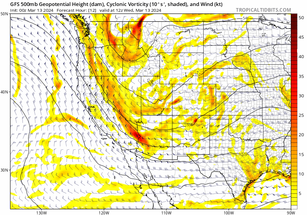
One key ingredient to the upcoming snowstorm across the Four Corner States will be a deep and slow-moving upper-level low that drops southward today from the Pacific Northwest and then meanders around the SW US for several days. Maps courtesy NOAA, tropicaltidbits.com
Overview
From a climatological point of view, March is a favorable time of year for accumulating snow in the Rocky Mountain States and it looks like “climatology” will come through this year. March is also quite an active month on average in terms of severe weather and indeed, an outbreak is possible later tomorrow and tomorrow night across the Mississippi Valley. Meanwhile, the Mid-Atlantic region will enjoy back-to-back-to-back unseasonably warm days featuring temperatures in the 70’s in many spots and spring fever may spread rapidly.

Several ingredients will come together for a significant accumulation of heavy, wet snow in the Denver/Boulder regions between later this evening and early Friday where 8-14 inches are a possibility. One of the ingredients will be a strong, deep and rather sustained upsloping flow of air from late tonight tonight into late Thursday. Map courtesy NOAA, tropicaltidbits.com
Rockies snowstorm
It is not unusual for significant accumulating snow to fall this time of year across the Rocky Mountain States; especially, on the back end of a winter that features an El Nino event in the tropical Pacific. A strong upper-level wave will drop southward from the Pacific Northwest during the next 24 hours and then meander around the southwestern states for several days. This slow-movement will help to result in a long-lasting snow event that is likely to result in significant snow for much of the Four Corners region and this will include the Denver metro region where 8-14 inches can fall between later this evening and early Friday morning. The precipitation in Denver will start out as rain later today and then transition to all snow by later this evening and continue heavy at times in the overnight hours and through the day on Thursday. Winds will become an increasing factor as well with gusts from late tonight through tomorrow at 30+ mph leading to blowing snow. The strengthening northeasterly winds that develop will allow for a stronger, deeper, and rather sustained upslope flow adding to the threat of heavy snow. The snow is likely to be of the heavy, wet texture which unfortunately, raises the possibility of some power outages. Across the foothills, as much as 2 or 3 feet of snow is likely to accumulate during this major winter storm event.

The severe weather threat later tomorrow and tomorrow night may be focused on the area between southeastern Oklahoma and western Arkansas where isolated tornadoes will be on the table. Map courtesy NOAA Storm Prediction Center
Severe weather threat focused on the Lower/Middle Mississippi Valley
March is often a time of severe weather in the US given the clash between increasingly warm and humid air masses flowing northward out of the Gulf of Mexico region and the continuing push to the south and east of cold, Canadian air masses. Indeed, this scenario is unfolding for late tomorrow and tomorrow night with an influx of warm, humid air into the Mississippi Valley region and the incoming cold, Canadian air mass that will be charging south and east across the Rocky Mountain States (and contributing to the snowstorm out there).

An influx of warm and humid Gulf of Mexico air on Thursday with be one contributing factor in the risk of severe weather across the Lower and Middle Mississippi Valley region by late in the day and tomorrow night. Map courtesy NOAA, tropicaltidbits.com
The greatest chance of severe weather later tomorrow and tomorrow night is likely to extend from southeastern Oklahoma to western Arkansas where isolated tornadoes are on the table. This severe weather threat could extend into early Friday morning across the Mississippi and Tennessee Valley regions.

Much warmer-than-normal air will dominate the Mid-Atlantic region today, Thursday and Friday with 70+ degrees in many spots. Map courtesy NOAA, tropicaltidbits.com
Spring fever alert in the Mid-Atlantic region
While the most active weather over the next couple of days will be in the western two-thirds of the nation, the Mid-Atlantic region will experience back-to-back-to-back unseasonably warm days with temperatures reaching the 70’s in many spots. High pressure pushed eastward on Tuesday and this new positioning is allowing for the eastward advance of some very mild air for this time of year and three days will likely see lots of spring fever declarations. Today and Thursday will feature plenty of sunshine and light winds to go along with the warm conditions, but Friday will likely contain some shower activity and maybe a thunderstorm or two.

Colder-than-normal air will push into the Mid-Atlantic region for much of the first half of next week and highs on Tuesday afternoon in the DC-to-Philly-to-NYC are likely to be confined to the 40’s as compared with the 70’s expected today, tomorrow and Friday. Map courtesy NOAA, tropicaltidbits.com
The weather turns cooler this weekend following the passage of a cool front, but temperatures will still be well above normal for the middle of March. Much colder air will pour into the area early next week and Tuesday’s high temperatures in the DC-to-Philly-to-NYC corridor are likely to be held down to the 40-45 degree range as compared with the 70-75 degree range of the next three days.
Meteorologist Paul Dorian
Arcfield
arcfieldweather.com
Follow us on Facebook, Twitter, YouTube
Video discussion: