
1:00 PM | ***Tornadoes on Sunday across Oklahoma and Kansas...an enhanced threat of severe weather on Tuesday across portions of Wisconsin, Iowa, Illinois, and Missouri as active pattern continues***
Paul Dorian

The number of tornadoes across the US has surged from late April until now and this has placed the year-to-date totals at well above-normal levels for the date. Plot courtesy NOAA/SPC
Overview
The number of tornadoes across the nation has surged in the last four weeks to overall levels that are now well above normal for the current time of year. One of the catalysts for these severe weather outbreaks has been the continuation of colder-than-normal air masses that have been dropping south and east from Canada into the US and this has set up “battle zone” regions when interacting with warm, humid air flowing northward from the Gulf of Mexico. In addition, there have been and will continue to be multiple waves of energy riding across the northern US enhancing upward motion in many of these severe weather cases. This active weather pattern will continue through the rest of May and Tuesday afternoon and evening may feature yet another severe weather outbreak including tornadoes across portions of Wisconsin, Illinois, Iowa, and Missouri.

The threat of severe weather on Tuesday will be “enhanced” in portions of Wisconsin, Iowa, Illinois, and Missouri. Map courtesy NOAA/SPC
Details
While not the only ingredient, the continuing influx of colder-than-normal air masses from Canada into the US during the past few weeks has contributed to numerous severe weather outbreaks and, in some cases, tornadic activity. The influx of colder than air has resulted in some late season accumulating snow across many higher elevation locations of Wyoming and Montana, and the interaction downstream from there with warm and humid air originating over the Gulf of Mexico has resulted in severe weather outbreaks across the heartland. One such volatile weather pattern took place on Sunday in the middle of the country and numerous tornadoes formed in Oklahoma and Kansas which continues a surge of activity in recent weeks. In fact, the time period between late April and yesterday, May 19th, has seen the overall number of tornadoes climb dramatically across the US to well above-normal levels for the current time of year...and the surge is not over.

One contributing factor in the numerous severe weather outbreaks in recent weeks has been the continuing onslaught of colder-than-normal air masses from Canada into the US. These cold, dry air masses dropping to the south and east have frequently interacted with warm, humid air masses flowing northward from the Gulf of Mexico setting up “battle zone” regions in the atmosphere…and often severe thunderstorm activity. Map courtesy NOAA, tropicaltidbits.com
On Tuesday, May 21st, an upper-level trough over the central Plains will push northeastward to the Upper Great Lakes region resulting in strong height falls and surface cyclogenesis across the Midwestern states of Wisconsin, Iowa, Missouri, and Illinois. Meanwhile, warm and humid air will be pushing northward into the Upper Midwest/Great Lakes region at the same time a surface cold front surges to the east across the Northern Plains. Given the ample amount of upper-level support and the ”battle” between the incoming colder-than-normal air mass to the north and west with the warm, humid air to the south and east, severe thunderstorms are likely to break out later Tuesday and Tuesday night. Low-level wind shear will increase as well later tomorrow in this part of the nation and the end result may be a few strong tornadoes in the region to include Wisconsin, Iowa, Illinois, and Missouri…and this threat zone area can end up extending eastward to the state of Michigan.
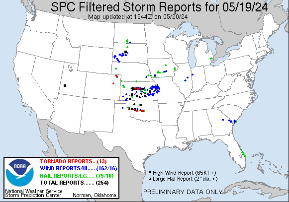
Numerous tornadoes were reported on Sunday across Oklahoma and Kansas and this continues a surge across the nation since late April. Plot courtesy NOAA/SPC
This threat of severe weather will slide a bit to the south and east on Wednesday with a chance for strong-to-severe thunderstorms extending at mid-week all the way from central Texas to the northern Ohio Valley. On Wednesday night and Thursday, it is possible for some strong-to-severe thunderstorm activity to reach the eastern states including the I-95 corridor as this ongoing active weather pattern continues through the week.
Meteorologist Paul Dorian
Arcfield
arcfieldweather.com
Follow us on Facebook, Twitter, YouTube
Video discussion: