2:30 PM | *A comfortable weekend...a comfortable week ahead...and its looking like a comfortable month of August in the Mid-Atlantic region...tropics to remain active*
Paul Dorian
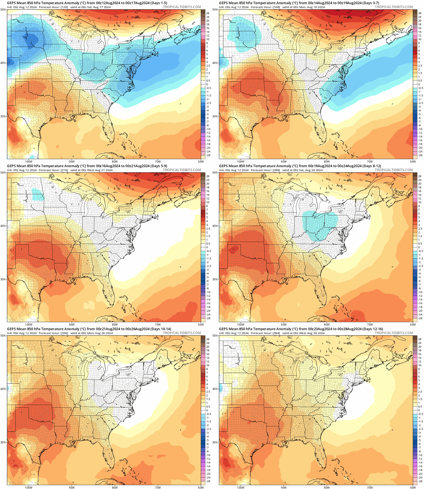
Multiple cooler-than-normal or nearly normal air masses will drop into the northeastern states from Canada during the next couple of weeks diminishing greatly any chances for sustained periods of extreme heat. Maps courtesy Canadian Met Centre, tropicaltidbits.com
Overview
The weekend just past in the Mid-Atlantic region was quite comfortable with plenty of sunshine on both days and the remainder of the week ahead looks quite comfortable as well for the middle of August. In fact, the rest of August may very well turn out to be quite comfortable across the Mid-Atlantic region with no signs of sustained extreme heat pretty much anywhere in the eastern half of the nation.
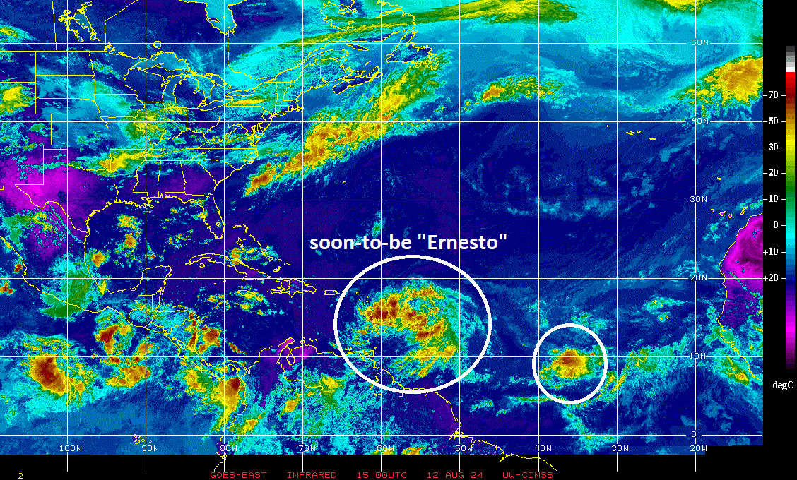
While the weather is quiet in the Mid-Atlantic region for much of this week, the tropical scene in the Atlantic Basin is active and it is likely to stay quite active during the remainder of August. A strong tropical wave that is currently closing in on the Leeward Islands is very likely to become a named tropical storm (Ernesto) during the next 24 hours and then it’ll impact Puerto Rico by mid-week – perhaps as a category 1 hurricane – and then likely move towards the island of Bermuda as an even stronger hurricane. A second tropical wave follows close behind and is currently located over the central tropical Atlantic and a third can be seen on satellite imagery near the west coast of Africa.
Comfortable conditions for the Mid-Atlantic
The past weekend featured very comfortable temperatures and humidity levels in the Mid-Atlantic region as well as plenty of sunshine on both days. Indeed, the week ahead looks similarly comfortable and there are signs that much of the remainder of August can turn out to be comfortable with no sustained extreme heat in the Mid-Atlantic region. Multiple nearly normal of even cooler-than-normal air masses are likely to drop into the northeastern states from Canada during the next couple of weeks greatly inhibiting the chances for sustained high heat.
In terms of rainfall, the Mid-Atlantic region suffered through copious amounts of rainfall late last week impacted by the remnants of Tropical Storm Debby. In fact, as much as 5 or 6 inches fell in some portions of the region and flash flooding was a widespread result of the heavy rainfall. The next few days look dry overall and there can be a return to unsettled weather by the weekend. As far as the longer term is concerned with respect to rainfall for the Mid-Atlantic, a lot will depend on potential impact by tropical systems that may form in the Atlantic Basin during the remainder of August.
The tropics are likely to remain quite active in the Atlantic Basin during the remainder of August. There are two waves currently with the frontrunning system very likely to become a named tropical storm (Ernesto) in the near-term (left circled region). There is a follow-up system that is close behind that will also need to be monitored in coming days and a third one near the west coast of Africa. Image courtesy University of Wisconsin/CIMSS, NOAA
On the tropical scene...
A strong tropical wave is currently closing in on the Leeward Islands and is moving westward at a fast clip of about 26 mph. This system will likely become a named tropical storm, Ernesto, during the next 24 hours and then likely impact Puerto Rico by mid-week...perhaps as a category 1 hurricane. After that, the tropical system is likely to begin a turn to the northwest and then north as it treks over the open waters of the Atlantic. Signs point to significant additional intensification at this time and it’ll ultimately approach the island of Bermuda...perhaps as a category 2 or 3 hurricane.
There will be three key players in the upper atmosphere that will influence the ultimate path of “Ernesto”…two troughs of low pressure and one high pressure ridge that is sandwiched in between. Map courtesy Canadian Met Centre, tropicaltidbits.com
There are three systems in the upper atmosphere that will have an influence on the ultimate path of Ernesto and there are still some questions as to how they’ll interact with each other down the road. Specifically, there will be two upper-level troughs– one over the northwestern Atlantic and the other headed towards the Great Lakes – and an upper-level ridge that will try build into southeastern Canada in between these two troughs. The initial (eastern-most) trough will likely contribute to a reduction in speed of Ernesto this weekend as it “leaves it behind” over the western Atlantic. The second (western-most) trough is likely to then “push” Ernesto more rapidly to the north-northeast and potentially towards the Canadian Maritime Provinces of Nova Scotia and/or Newfoundland sometime early next week.
Meteorologist Paul Dorian
Arcfield
arcfieldweather.com
Follow us on Facebook, Twitter, YouTube
Video discussion:


