
2:45 PM | **"Debby" to produce tremendous rainfall amounts in the SE US...2nd landfall likely after some re-intensification...enhanced heavy rain threat in Mid-Atl. begins as early as late tomorrow**
Paul Dorian
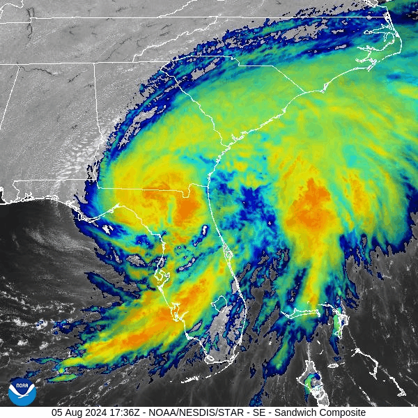
Hurricane Debby made landfall earlier today as a category 1 storm and has weakened to “tropical storm” status. Despite the weakening, this tropical system is likely to produce tremendous rainfall amounts over portions of the SE US during the next few days. Images courtesy NOAA/NESDIS/STAR GOES-East (“Sandwich RGB” Band which combines IR Band 13 with Visual Band 3)
Overview
Debby made landfall this morning in the Big Bend region of Florida’s Gulf coast as a category 1 hurricane. While Debby has weakened to “tropical storm” status, it will likely produce tremendous rainfall amounts in portions of the Southeast US during the next few days as its northward progression is stymied by high pressure ridging building to its north. The remnants of Debby will then push off the Georgia/South Carolina coastline by mid-week and it can undergo some re-intensification over the open waters of the southwestern Atlantic. In fact, there is the chance that Debby returns to category 1 hurricane status depending on its length of time over the southwestern Atlantic Ocean. By Wednesday night or early Thursday, Debby will likely make a second landfall perhaps over the northeastern coastline of South Carolina.
Farther north, tropical moisture associated with Debby can enhance the threat for heavy rainfall in the Mid-Atlantic region as soon as late tomorrow as it interacts with an incoming cold frontal system. Following the frontal passage on Wednesday, it turns much cooler in the Mid-Atlantic region for the second half of the week with afternoon highs generally confined to the 70’s in places like DC, Philly and New York City. There will also be a continuing threat of tropical rainfall later this week as the remnants of Debby finally kick out of the SE US by the end of the week and push to the north…several inches of rain are on the table in the Mid-Atlantic between now and the end of the upcoming weekend.

Tremendous rainfall amounts of between 10 and 20 inches are on the table during the next couple of days across portions of the Southeast US. In fact, 30 inches is a possibility in some isolated spots across the SE Us coastline. Farther north, heavy rainfall amounts of several inches are possible in the Mid-Atlantic region between now and the end of the upcoming weekend. Map courtesy NOAA/WPC, Dr. Ryan Maue (X), weathermodels.com
Southeast US
A tropical wave exited off of Cuba’s northwest coast early in the weekend and quickly reached tropical storm status as it moved over the very warm waters of the eastern Gulf of Mexico. Intensification continued late yesterday and last night and Debby reached category 1 hurricane status just before making landfall early Monday in the Big Bend region of Florida’s Gulf coast. Now over land, this system has weakened to “tropical storm” status and its northward progression will be impeded over the next couple of days by building high pressure ridging across the Carolinas/Mid-Atlantic. In fact, it’ll likely take until early tomorrow for TS Debby to reach the coastline of Georgia.
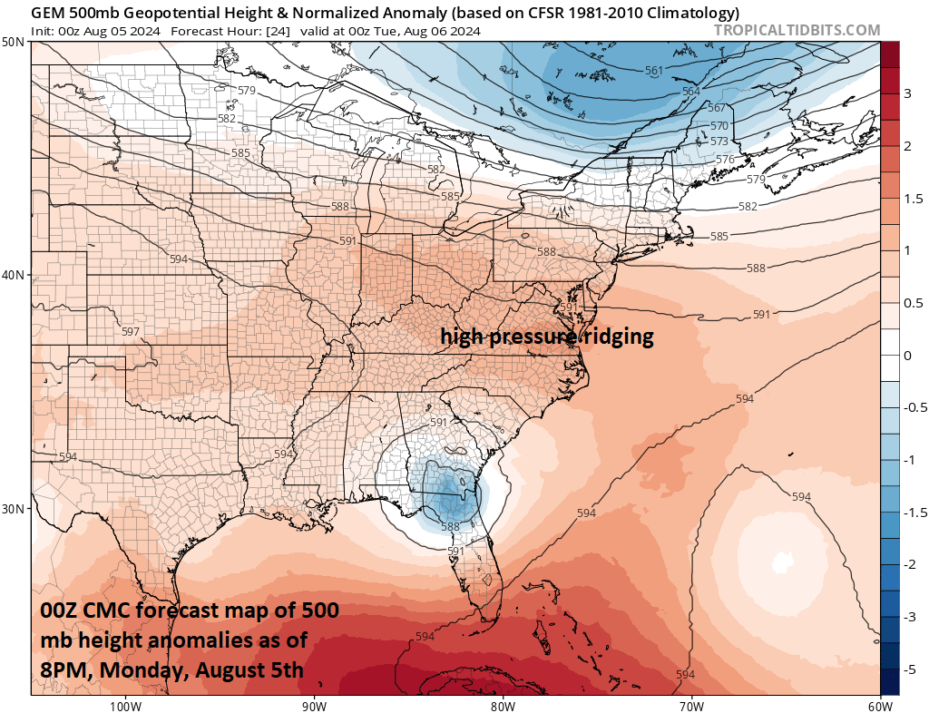
High-pressure ridging in the upper part of the atmosphere builds across the Carolinas/Mid-Atlantic today and this will act to impede the northward progression of Hurricane Debby over the next few days. The slow movement of the tropical storm system will allow for some tremendous rainfall amounts to pile up in the SE US during the next 48-72 hours. Map courtesy Canadian Met Centre
After that, TS Debby is likely to move back out over the open waters of the southwestern Atlantic Ocean just off the coast of South Carolina and it very well could intensify back into category 1 hurricane status depending on its length of time over the open waters. By early Thursday, the re-invigorated Debby is likely to make a second landfall – perhaps over the central coastline of South Carolina – and then it may finally push to the north by the end of the week. As a result of the slow movement of Debby, rainfall amounts are likely to become excessive across portions of the Southeast US during the next couple of days with 10-20 inches on the table and even an outside chance of 30 inches in some isolated spots.

The black line one this forecast map represents the predicted track of Debby over the next several days as depicted by the 00Z Euro Ensemble run. Map courtesy ECMWF, Tony Pann (X)
Mid-Atlantic
Despite the fact that the center of Debby will likely not move to the Mid-Atlantic region until the end of the week (and that is not a 100% guarantee), its influence will begin here as early as late Tuesday. In fact, there can be some very heavy rainfall in portions of the Mid-Atlantic region later tomorrow or tomorrow night aided by the combination of an influx of tropical moisture associated with Debby and an incoming cold frontal system. That cold front grudgingly works its way through the Mid-Atlantic region on Wednesday and then it’ll stall out in rather close proximity. This stalled-out boundary zone will then act as a pathway for additional tropical moisture to flow northward into the Mid-Atlantic region during the remainder of the week...and “tropical-moisture enhanced” heavy rainfall will remain a continuing threat with several inches on the table between later tomorrow and early in the upcoming weekend. Temperatures will respond significantly on Wednesday with the (reluctant) passage of the cold front and it’ll remain noticeably cooler on Thursday and Friday as well with highs on all three days confined to the 70’s in places like Philly and New York City following the very warm and humid conditions of today and tomorrow.
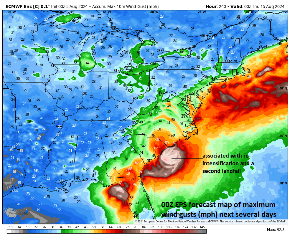
Heavy rainfall will not be the only weather parameter of note associated with Hurricane Debby in coming days along the eastern seaboard…wind gusts can be quite high and noteworthy as well as depicted here in the forecast map by the 00Z Euro model run of highest wind gusts encompassing the full duration of this tropical storm system. Map courtesy Weather Bell Analytics, ECMWF
Meteorologist Paul Dorian
Arcfield
arcfieldweather.com
Follow us on Facebook, Twitter, YouTube
Video discussion: