
1:00 PM | ***”Major” hurricane threat continues for Florida’s Gulf coast...landfall possible late Thursday in the "Big Bend" region...Georgia to be hit hard as well***
Paul Dorian

Hurricane-force winds can extend from Florida to Georgia and South Carolina during this upcoming storm system as depicted here by the 06Z run of NOAA’s GFS model. Map courtesy NOAA, Weather Bell Analytics
Overview
A strong tropical wave continues to churn over the warm waters of the western Caribbean Sea and it is likely to threaten Florida’s Gulf coast as a “major” hurricane by late Thursday. This system should attain named tropical storm status shortly (minimum winds of 39 mph) and then it should take a track in between the Yucatan Peninsula of Mexico and the western tip of Cuba as it heads to the southern Gulf of Mexico. Intensification will then continue as it heads on a general northward track over the warm waters of the eastern Gulf and it could climb to “major” hurricane classification (i.e., category 3 or higher) before a likely landfall late Thursday somewhere near Florida’s “Big Bend” Gulf coast region.
After landfall, the remnants of the hurricane will push in a general northward direction through Georgia and South Carolina producing powerful wind gusts and significant rainfall along the way. At this point, the tropical system will become increasingly influenced by very strong “blocking” high pressure to the north and an upper-level trough of low pressure dropping southeastward into the south-central states. In fact, the tropical low may “rotate around” this incoming upper-level trough of low pressure for a brief time in a pattern known to meteorologists as the “Fujiwhara effect” before it ultimately gets absorbed by the upper-level low..

Rainfall amounts from the upcoming storm system can be excessive not only across the state of Florida, but also farther north into the southern Appalachians as depicted here by the 00Z Euro model. Map courtesy ECMWF, Weather Bell Analytics
Discussion
The “capping lid” of recent days has come off the atmosphere over the Atlantic Basin with an increase in upward motion that has led to the formation of this strong tropical system over the western Caribbean Sea. Intensification should continue over the next couple of days with these more favorable environmental conditions featuring as the tropical storm spills out over the Gulf of Mexico taking a track in between the Yucatan Peninsula region of Mexico and the western tip of Cuba. As such, it’ll maintain its strength as it heads to the Gulf of Mexico with its circulation center staying over very warm water.
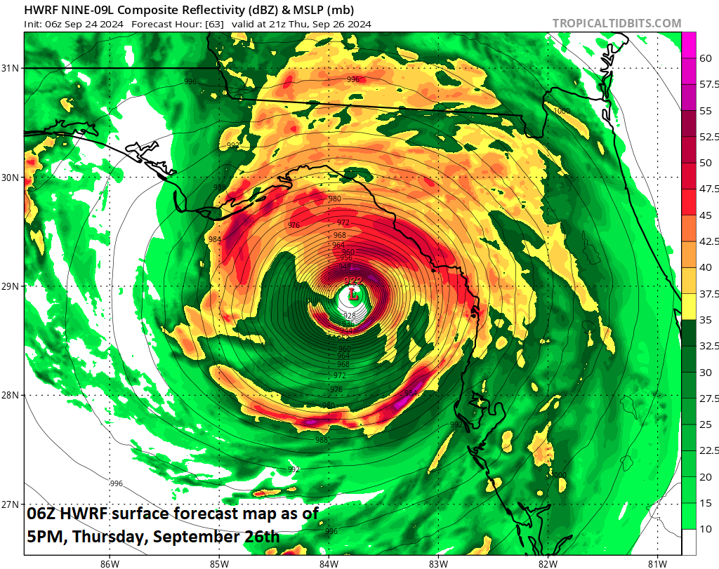
This particular run by NOAA’s HWRF model features a powerful hurricane nearing the Gulf coast of Florida by late Thursday. Map courtesy NOAA
By Thursday, “Helene” could very well reach “major” hurricane status of category 3 (minimum winds of 111 mph) as it heads towards the Big Bend region of Florida’s Gulf coast. Landfall could take place late in the day on Thursday and the potential “major” hurricane will likely produce a strong storm surge all the way down to the Tampa Bay region. The storm surge is usually highest to the right of the track of a northward-moving tropical system given the “additive” to the counterclockwise wind flow and forward speed of the storm system (for more info on storm surge, check out the ”Hurricane Storm Surge” video on our “Meteo 101” page). Note: a slight shift to the east of this expected storm track would raise the chance of even more serious impact to the Tampa Bay region. If indeed “Helene” reaches Florida’s Gulf coast as a “major” hurricane on Thursday, it would be the 9th since the year 2000 with the most recent being “Idalia” in 2023. The full list of “major” hurricane hits in Florida since 2000 follows: 2004 Charley, Jeanne; 2005 Dennis, Wilma; 2017 Irma; 2018 Michael; 2022 Ian; 2023 Idalia.

NOAA's latest official tropical storm track suggests landfall sometime late Thursday along Florida's Gulf coast “Big Bend” region. The storm surge can be significant anywhere to the right of the landfalling location meaning residents down to the Tampa Bay region should be on alert. Map courtesy NOAA/NHC
After landfall, the remnants of the hurricane later this week will continue on a general northward track through the states of Georgia and South Carolina potentially producing hurricane-force wind gusts along the way. In addition, rainfall can become excessive with heavy amounts possible all the way up to the southern Appalachians in coming days. The remnants of the hurricane will then become increasingly influenced by very strong upper-level ridging over southern Canada. In addition, an upper-level trough of low pressure which had its origins over the Northern Plains will drop into the south-central states and this system will also influence the movement of the tropical system later in the week. The high pressure to the north is essentially a “blocking” type of system; consequently, the remnants of the tropical system will be limited in its northward progression...perhaps into the southern Mid-Atlantic region.

After landfall, the remnants of “Helene” will interact with an upper-level trough of low pressure dropping into the south-central states (shown in blue) and also very strong upper-level high pressure ridging over southern Canada (shown in orange/red). As a result, the remnants of the hurricane (to be named Helene) will grind to a halt in its northward progression and will "rotate around" the incoming upper-level trough of low pressure (the so-called "Fujiwhara effect"). Maps courtesy NOAA, tropicaltidbits.com
In fact, the remnants of the tropical storm will likely “rotate around” the upper-level trough for a couple of days in a scenario that meteorologists refer to as the “Fujiwhara effect” (a phenomenon that occurs when two cyclonic vortices, such as hurricanes or tornadoes, get close enough to each other to begin rotating around a common center point. The effect is named after Japanese meteorologist Sakuhei Fujiwhara, who first described it in a 1921 paper). Ultimately, the remnants of tropical low will become “absorbed” by the upper-level trough.

Storm surge is typically most significant to the right of a northward-moving landfalling hurricane and, in this case, that may end up being the region depicted in "purple" (10-15 feet) on this map given the current expected track of "Helene" towards the "Big Bend" region of Florida's Gulf coast. Map courtesy NOAA
Looking ahead, this developing tropical system is indicative of a significant change to the overall large-scale weather pattern in the Atlantic Basin…one that is much more conducive to the formation and intensification of tropical systems. This change is the result of a re-positioning of a tropical disturbance known as the “Madden-Julian Oscillation” and it is leading to enhanced upward motion over the Caribbean Sea and Gulf of Mexico. This more favorable weather pattern for tropical cyclone activity will likely last well into the month of October.
Meteorologist Paul Dorian
Arcfield
arcfieldweather.com
Follow us on Facebook, Twitter, YouTube
Extended video discussion: