
***Hurricane Helene headed for Florida’s Gulf coast likely as a "major" with landfall early Thursday night...Georgia/southern Appalachians to be hit hard***
Paul Dorian

A very "healthy-looking" Helene at this hour which is on the door step of category 1 hurricane classification. “Gravity waves” or “transverse-banding” can be seen on the southern and western sides of the storm’s center in this infrared satellite imagery loop which is usually indicative of rapid intensification. Images courtesy NOAA, College of DuPage
Overview
Tropical Storm Helene has strengthened during the past 24 hours and is on the verge of attaining “category 1” hurricane status with sustained winds of 74-95 mph. All indications are that Helene will undergo rapid intensification during the next 24 hours or so given the combination of favorable environmental conditions such as low vertical wind shear and ample moisture, and its movement over very warm water with high oceanic heat content. This expected intensification of Helene will likely result in attainment of “major” hurricane classification on Thursday as a category 3 storm system with sustained winds of 111 mph – 129 mph. Helene should begin to accelerate tomorrow in a north-to-northeast direction likely resulting in a landfall early tomorrow night along Florida’s “Big Bend” Gulf coastal region. As is typical of northward moving tropical storms, the storm surge should be most impactful to the right of the landfall location potentially affecting coastal sections down to areas just north of Tampa Bay. In addition, there will be the threat of tornadoes to the right of the storm’s track including portions of northern and eastern Florida, Georgia and South Carolina.
After landfall, the remnants of the hurricane will move along at a pretty good clip in a general northward direction through the state of Georgia where there is likely to be significant impact including hurricane-force wind gusts and excessive rainfall amounts. In fact, excessive rainfall may extend to throughout much of the southern Appalachians where strong upsloping winds will enhance upward motion and increase overall amounts. By mid-day on Friday, the tropical system will become increasingly influenced by very strong “blocking” high pressure to the north and an upper-level trough of low pressure located in the southern Mississippi Valley. The tropical low will “rotate around” this upper-level trough of low pressure for a brief time in a pattern known to meteorologists as the “Fujiwhara effect” before it ultimately dissipates and gets absorbed by the upper-level low.

NOAA’s latest official storm track for “Helene” maintains hurricane status into the state of Georgia. Map courtesy NOAA/NHC
Details
Tropical Storm Helene is on the verge of attaining hurricane status (category 1) as it moves over the eastern tip of the Yucatan Peninsula and towards the southern Gulf of Mexico. This would make Helene the 5th hurricane of the 2024 tropical season which is right around the average date of September 28th for that to take place. Latest satellite imagery shows a “healthy-looking” system and even “gravity waves” or “transverse banding” on the southern and western side of the storm’s center which generally is associated with rapid intensification, pointing to favorable ventilation of the ongoing convective burst near the core circulation.

Current sea surface temperatures are fully supportive of rapid intensification of “Helene” during the next 24 hours or so. Map courtesy NOAA, tropicaltidbits.com
Sea surface temperatures throughout the southern and eastern Gulf of Mexico are in the mid-to-upper 80’s and are very supportive of rapid intensification. Indeed, the combination of the warm water with high oceanic heat content (meaning it is warm at the surface and well below the surface), and the increasingly favorable environmental conditions of low vertical wind shear and ample moisture will result in a rapid strengthening of Helene during the next 24 hours or so. As such, “major” hurricane classification as a category 3 storm is likely with sustained winds of 111 mph or higher as the threshold.

06Z NAM forecast map of maximum wind gusts (mph) through Friday morning. Map courtesy NOAA, Weather Bell Analytics
The latest measurements on TS Helene show a movement to the NW at 9 mph and signs point to an acceleration on Thursday in a general north-to-northeast direction. As such, Helene is likely to make landfall early tomorrow night as a “major” hurricane somewhere along Florida’s “Big Bend” Gulf coastal region. Storm surge is typically most impactful on the right side of the landfalling location as the result of the “additive” effect of the storms forward speed which combines with surface winds that tend to blow water onshore in that particular quadrant of the storm (i.e., to the right of the landfalling location). (For more information on “storm surge”, check out the ”Hurricane Storm Surge” video on the “Meteo 101” page at arcfieldweather.com). Helene is also likely to become quite a large storm which would likely result in a very large sized wind field well away from the center. Bottom line, all residents from the Big Bend region of Florida’s Gulf coast down to near Tampa Bay should take the usual precautions ahead of an approaching powerful hurricane with damaging winds and flooding rainfall.
If indeed “Helene” reaches Florida’s Gulf coast as a “major” hurricane late Thursday, it would be the 9th such storm since the year 2000 with the most recent landfalling “major” hurricane being “Idalia” in late August 2023. The full list of “major” hurricane hits in Florida since 2000 is as follows: 2004 Charley, Jeanne; 2005 Dennis, Wilma; 2017 Irma; 2018 Michael; 2022 Ian; 2023 Idalia.

06Z NAM forecast map of total rainfall amounts through Saturday morning. Map courtesy NOAA, Weather Bell Analytics
After landfall, Hurricane Helene will continue on a general northward track into the state of Georgia where impact may be quite significant featuring hurricane-force wind gusts and excessive rainfall amounts. In fact, excessive rainfall amounts will be possible in much of the southern Appalachians where upsloping winds will enhance upward motion and help to squeeze out the tropical moisture in the atmosphere in the form of heavy rainfall. In addition to the winds and rain, tornadoes will be likely during this event; especially, on the right side of the northward-advancing hurricane to include portions of northern and eastern Florida, Georgia and South Carolina. The main cause of concern for Georgia (and this includes the Atlanta metro) in terms of a potential big-time impact from the hurricane lies in the fact that Helene will accelerate on Thursday and its fast forward speed should result in a farther inland penetration of its powerful winds compared to slower moving systems (i.e., there will be less time for the hurricane to weaken once over land). The remnants of the hurricane will then become increasingly influenced by very strong upper-level ridging over southern Canada and an upper-level low over the south-central states. The high pressure to the north is essentially a “blocking” type of system; consequently, the remnants of the hurricane will not be able to push to the northeastern part of the nation, but rather, it will be forced to take a turn to the north and west once it reaches the Tennessee Valley around mid-day on Friday.

In fact, the remnants of the hurricane will likely “rotate” or “dance” around the upper-level low for a short time in a scenario that meteorologists refer to as the “Fujiwhara effect” (a phenomenon that occurs when two cyclonic vortices, such as hurricanes or tornadoes, get close enough to each other to begin rotating around a common center point. The effect is named after Japanese meteorologist Sakuhei Fujiwhara, who first described it in a 1921 paper). Ultimately, the remnants of the hurricane will dissipate and become fully “absorbed” by the upper-level low. One final note, despite the “block” in the atmosphere, some of the tropical moisture field is likely to make it into the Mid-Atlantic region for the late week/early weekend time period.
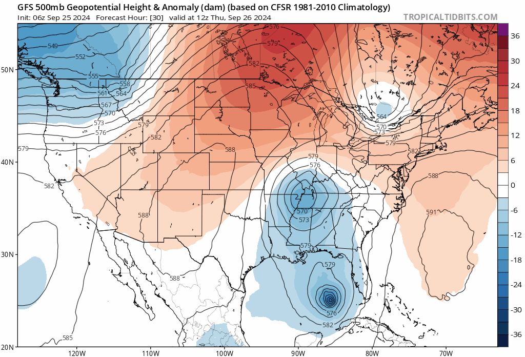
After landfall, the remnants of “Helene” will interact with an upper-level trough of low pressure dropping into the south-central states (shown in blue) and also very strong upper-level high pressure ridging over southern Canada (shown in orange/red). As a result, the remnants of the hurricane (to be named Helene) will grind to a halt in its northward progression and will "rotate around" the incoming upper-level trough of low pressure (the so-called "Fujiwhara effect"). Maps courtesy NOAA, tropicaltidbits.com
Looking ahead, this developing hurricane is the first sign of a significant weather pattern change in the Atlantic Basin…one that is much more conducive to the formation and intensification of tropical systems compared to recent weeks. This pattern change is largely the result of a re-positioning of a tropical disturbance known as the “Madden-Julian Oscillation” and it is leading to enhanced upward motion over places like the Caribbean Sea and Gulf of Mexico. This more favorable weather pattern for tropical cyclone activity will likely last well into the month of October so Helene will very likely not be the last named storm of the 2024 Atlantic Basin tropical season.
Meteorologist Paul Dorian
Arcfield
arcfieldweather.com
Follow us on Facebook, Twitter, YouTube
Video discussion: