
2:45 PM | ****Hurricane Helene headed for Florida’s Gulf coast as a "major"...landfall early tonight...Georgia to be hit hard...southern Appalachians especially vulnerable to severe flooding****
Paul Dorian
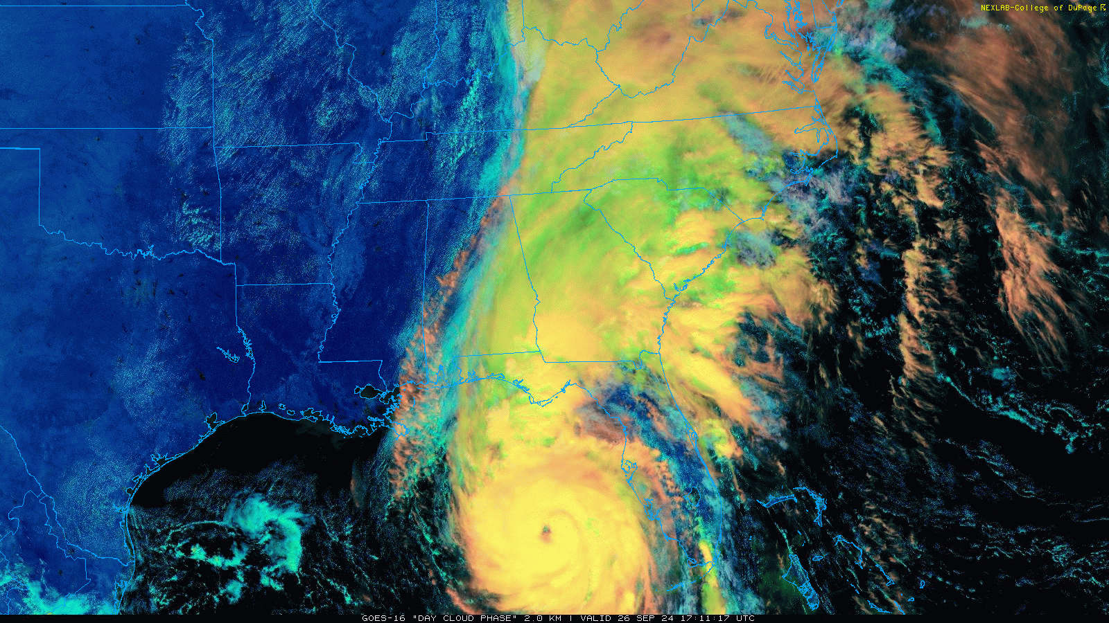
Hurricane Helene is pushing to the north-northeast with a likely landfall early tonight in Florida’s “Big Bend” Gulf coastal region. Images courtesy NOAA (GOES-East), Colle of DuPage
Overview
Hurricane Helene has strengthened during the past 24 hours and is now classified as a strong category 2 hurricane with maximum sustained winds of 110 mph. It should continue to intensify today as it closes in on Florida’s Gulf coast with the likelihood of reaching category 3 hurricane status featuring sustained winds of 111 mph or higher and category 4 designation is still on the table. Landfall is expected early tonight along Florida’s “Big Bend” Gulf coastal region as a “major” with a significant storm surge; especially, just to the right of the landfalling location where levels can reach 15-20 feet. With some acceleration expected later today, Helene will not have much time to weaken after landfall and, as such, it is likely to reach into southern Georgia as a hurricane during the wee hours of the morning. The lasting strength of Helene and its expected track into the Tennessee Valley assures significant impact inland to include the state of Georgia, and an especially vulnerable region is the southern Appalachian Mountains where upsloping winds can result in massive rainfall amounts of 1-2 feet and severe flash flooding.
By mid-day on Friday, the tropical system will become increasingly influenced by very strong “blocking” high pressure to the north and an upper-level trough of low pressure located in the southern Mississippi Valley. The tropical low will “rotate around” this upper-level trough of low pressure for a brief time in a pattern known to meteorologists as the “Fujiwhara effect” before it ultimately dissipates and gets absorbed by the upper-level low.

00Z Euro surface forecast map as of 11 PM, Thursday, September 26th with landfall of Hurricane Helene along Florida’s Gulf coast. Map courtesy ECMWF, Weather Bell Analytics (Meteorologist Joe Bastardi, X)
Details
Hurricane Helene is now classified as a strong category 2 hurricane with sustained winds of 110 mph and is moving N-NE at 16 mph. Sea surface temperatures through much of the eastern Gulf of Mexico are in the mid-to-upper 80’s and are supportive of additional intensification. Indeed, the combination of the warm water with high oceanic heat content (meaning it is warm at the surface level and well below the surface), and the increasingly favorable environmental conditions of low vertical wind shear and ample moisture will likely result in attainment of category 3 “major” hurricane status later today with sustained winds of 111 mph or higher and a climb to “category 4” is still on the table.

00Z Euro forecast maps of maximum wind gusts (left) and total rainfall amounts (right) for the period between now and 8 PM, Friday, September 27th with the southern Appalachians an especially vulnerable area for substantial rainfall amounts and flash flooding. Maps courtesy ECMWF, Weather Bell Analytics (Meteorologist Joe Bastardi, X)
Hurricane Helene will accelerate today which should put it on track to reach Florida’s “Big Bend” coastal region later this evening. Hurricane Helene’s storm surge will be significant along Florida’s Gulf coast; especially, to the right of the landfalling location where levels can reach 15-20 feet as there is an “additive” effect of the storm’s forward speed combined with surface winds that tend to blow water onshore in that particular quadrant of the system. (For more information on “storm surge”, check out the ”Hurricane Storm Surge” video on the “Meteo 101” page at arcfieldweather.com).

NOAA’s forecast map of “peak storm surge” associated with Hurricane Helene with the highest levels of as much as 15-20 feet possible just to the right of the landfalling location. Map courtesy NOAA/NHC
If indeed “Helene” reaches Florida’s Gulf coast as a “major” hurricane later this evening, it would be the 9th such storm since the year 2000 with the most recent landfalling “major” hurricane being Idalia in late August of last year. The full list of “major” hurricane hits in Florida since 2000 is as follows: 2004 Charley, Jeanne; 2005 Dennis, Wilma; 2017 Irma; 2018 Michael; 2022 Ian; 2023 Idalia.

Strong and persistent upsloping winds during this upcoming tropical event can result in substantial rainfall amounts of as much as 1-2 feet and severe flash flooding conditions across the southern Appalachians including upstate Georgia, upstate South Carolina, and western North Carolina.
After landfall, Hurricane Helene will continue on a general northward track into the state of Georgia where impact is likely to be quite significant featuring hurricane-force wind gusts, excessive rainfall amounts and power outages. And a particularly vulnerable region for significant impact will be the southern Appalachians (upstate Georgia, upstate South Carolina, western North Carolina) where strong and persistent upsloping winds will enhance upward motion and potentially result in massive rainfall amounts of as much as 1-2 feet and severe flash flooding conditions. In addition to the threat of powerful winds and torrential rainfall, tornadoes will be likely during this tropical weather event; especially, on the right side of the northward-advancing storm to include portions of northern and eastern Florida, eastern Georgia, and southeastern South Carolina.
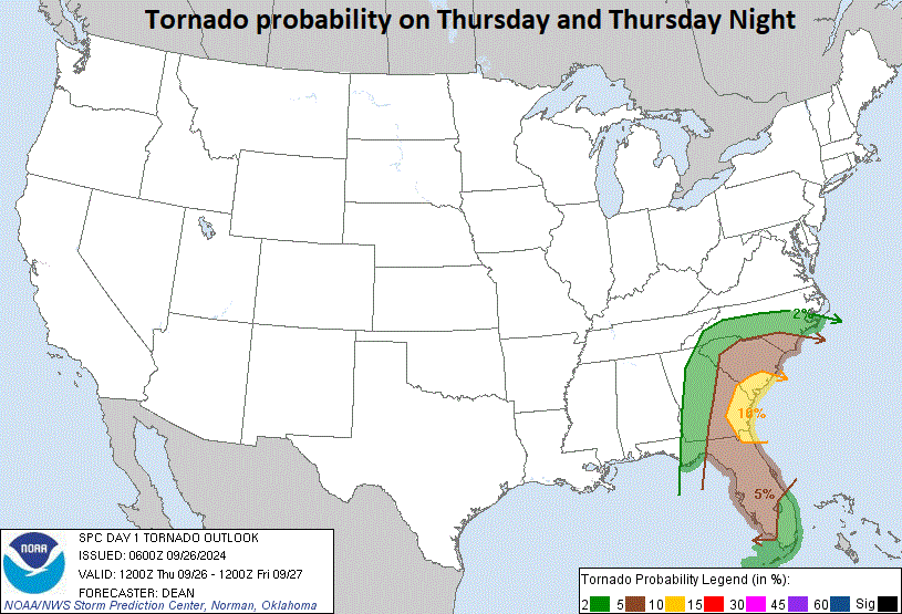
Storm surge is often highest just to the right of the landfalling location and the threat of tornadoes is also highest to the right of the northward-advancing storm. In this case, the threat of tornadoes should be highest across northern and eastern Florida, eastern Georgia, and southeastern South Carolina. Map courtesy NOAA/SPC
By mid-day on Friday, the remnants of the hurricane will become increasingly influenced by very strong upper-level ridging over southern Canada and an upper-level low over the south-central states. The high pressure to the north is essentially a “blocking” type of system; consequently, the remnants of the hurricane will not be able to push to the northeastern part of the nation, but rather, it will be forced to take a turn to the north and west once it reaches the Tennessee Valley. In fact, the remnants of the hurricane will likely “rotate” or “dance” around the upper-level low for a short time in a scenario that meteorologists refer to as the “Fujiwhara effect” (a phenomenon that occurs when two cyclonic vortices, such as hurricanes or tornadoes, get close enough to each other to begin rotating around a common center point. The effect is named after Japanese meteorologist Sakuhei Fujiwhara, who first described it in a 1921 paper). Ultimately, the remnants of the hurricane will dissipate and become fully “absorbed” by the upper-level low.

Tropical Storm Isaac has just formed out over the central Atlantic Ocean which makes "9" for the number of named tropical systems this season. Map courtesy NOAA/NHC
Looking ahead with respect to the tropical scene, Hurricane Helene is a sign of a large-scale pattern change that has led to enhanced upward motion over much of the Atlantic Basin including the Caribbean Sea and Gulf of Mexico. As a result, there is likely to be additional tropical activity to deal with as we push through much of the month of October. In fact, there are signs that point to the possibility of another tropical system somewhere in the Gulf of Mexico in about 7-10 days. By the way, there is a newly formed named tropical storm (Isaac) currently churning out over the central Atlantic Ocean, but it has little chance of impacting any land mass. Tropical Storm Isaac is the 9th named storm of the 2024 Atlantic Basin tropical season and it is likely that those numbers will be added to in coming weeks.
Impact in the Mid-Atlantic region
As far as the Mid-Atlantic is concerned, while the center or tropical system will never make it this far north, some tropical moisture will combine with the upper-level low to produce rainfall in the region on Friday, Friday night, and Saturday and some of the rain can be heavy at times. In fact, there is a chance that the upper-level low will hang around long enough to produce some rainfall in the Mid-Atlantic region during the second half of the weekend and much of next week looks quite unsettled as well.
Meteorologist Paul Dorian
Arcfield
arcfieldweather.com
Follow us on Facebook, Twitter, YouTube
Video discussion: