
12:00 PM | *Climatological peak of the Atlantic Basin tropical season is just around the corner and there are now several systems to monitor after a very quiet stretch*
Paul Dorian

There are currently five separate tropical systems in the Atlantic Basin according to NOAA’s National Hurricane Center which will need to be monitored in coming days as we progress towards the climatological peak of the season. Map courtesy NOAA/NHC
Overview
The climatological peak of the Atlantic Basin tropical season is just around the corner and there are now as many as five systems to monitor in coming days after a very lengthy quiet period. In fact, there has not been a newly named tropical storm in the Atlantic Basin since “Ernesto” first reached that designation on August 12th, and this is the longest such quiet stretch since the late 1960’s. With five separate tropical systems currently showing some life in the Atlantic Basin and near-term changes coming to the overall weather pattern, the absence of named tropical storms is very likely to soon come to an end.
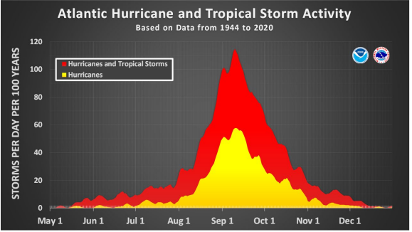
The climatological peak of the Atlantic Basin tropical season falls roughly somewhere between the 10th and 15th of September based on historical observations. Plot courtesy NOAA
Details
“Ernesto” intensified into a named tropical storm on August 12th as it neared the Leeward Islands at the front end of the Caribbean Sea, and it ultimately reached hurricane status out over the warm waters of the western Atlantic Ocean. Since “Ernesto”, there has not been a newly named tropical storm system in the Atlantic Basin and this quiet stretch from August 13th until today is the longest such since 1968 (credit to Dr. Philip Klotzbach, Colorado State University, X). What makes this quiet stretch even more unusual is that it happens to coincide with a climatologically busy time of year in the Atlantic Basin. In fact, the climatological peak of the tropical season is roughly somewhere between the 10th and 15th of September and certainly, the tropical scene now looks like it is going to live up to expectations. Indeed, there are five separate tropical systems across the Atlantic Basin and the dry spell with no newly named tropical storms is likely to come to an end within the next week or so.

Vertical wind shear has been quite high in the main development region of the tropical Atlantic (red regions) as depicted here for the current 5-day period by the 00Z EPS forecast model. This kind of pattern has been unfavorable in recent weeks for the formation and intensification of tropical activity in the Atlantic Basin. Map courtesy ECMWF, tropicaltidbits.com
One of the possible explanations of the recent quiet stretch in the Atlantic Basin has to do with the Madden-Julian Oscillation or MJO that is used as a metric to monitor an atmospheric wave that travels around the tropics on a regular basis. Embedded within this tropical disturbance are different phases of enhanced and suppressed precipitation. In the enhanced phase, the air is more likely to rise and produce thunderstorms while in the suppressed phase, thunderstorms have difficulty forming due to sinking air. The suppressed phase with sinking air has been dominate over much of the Atlantic Ocean in recent weeks, but that pattern is likely to change over the next 7 to 10 days or so. Specifically, there has been enhanced vertical wind shear in recent weeks over much of the Atlantic Ocean likely due in large part to the positioning of the MJO or tropical disturbance, and this has been an inhibiting factor for the formation or intensification of tropical systems. Other possible factors resulting in the recent quiet stretch include upper atmosphere temperatures and humidity levels over the Atlantic, Sahara Desert dry air from Africa, and solar activity which has been quite high in recent weeks.

Vertical wind shear will drop significantly by the middle of the month in the main development region of the tropical Atlantic (blue region) as depicted here by the 00Z EPS forecast model for mid-September. This kind of pattern is more favorable for the formation and intensification of tropical activity in the Atlantic Basin. Map courtesy ECMWF, tropicaltidbits.com
It appears that with a re-positioning of the MJO, vertical wind shear will become more conducive (i.e., more rising air) to the development and intensification of tropical activity as we reach (and pass) the climatological peak of the Atlantic Basin tropical season. In addition, sea surface temperatures across the Atlantic Basin remain at very warm levels and La Nina (colder-than-normal SSTs) continues to trend in the equatorial Pacific – both factors are favorable for Atlantic Basin tropical activity - so stay tuned, the quiet stretch is coming to an end.

The Madden-Julian Oscillation (MJO) is forecasted to rotate (counter-clockwise) through “phases” 5 and 6 in coming days and this re-positioning is likely to lead to more upward motion over the Atlantic Basin which is more favorable to the formation and intensification of tropical systems. Plot courtesy ECMWF, NOAA
Meteorologist Paul Dorian
Arcfield
arcfieldweather.com
Follow us on Facebook, Twitter, YouTube
Video discussion: