
**Tropical Storm Melissa has slowed down to a crawl...raises the chance of attaining “major” hurricane status...could have an impact on the east coast later next week**
Paul Dorian
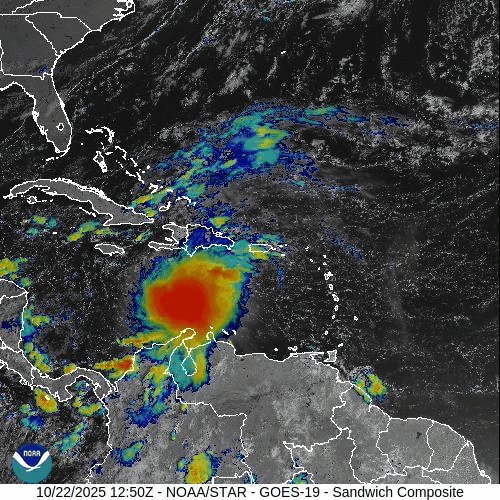
Tropical Storm Melissa has slowed down to a movement of only 2 mph (WNW) and this will allow for further intensification in coming days as it drifts over very warm water. Images courtesy NOAA/GOES-East
Overview
“Melissa” became the first named tropical storm of the year so far in the Caribbean Sea and it had been moving westward at a fairly rapid clip until just recently. A dramatic slowdown has taken place with Tropical Storm Melissa as it has moved into an area with very weak winds in the atmosphere. The slow movement of TS Melissa may last for the next several days and it is occurring over some very warm water in the central Caribbean...fully capable of supporting further intensification. Environmental conditions will become quite supportive of intensification as well in coming days with overall wind shear likely to diminish. This combination of favorable water temperatures for intensification along with improving environmental conditions raises the chance that TS Melissa intensifies all the way to “major” hurricane status by late this weekend or early next week. Looking ahead to later next week, with a deepening trough of low pressure likely to form just inland, there certainly can be some interaction between the inland trough and the western Atlantic tropical system…stay tuned; especially, if a resident in the Mid-Atlantic/Northeast US/New England.

Not only will the very warm water temperatures of the Caribbean Sea be favorable for further intensification of Tropical Storm Melissa, but so will atmospheric conditions as overall wind shear should diminish in its vicinity during the next several days. Map courtesy ECMWF, Weather Bell Analytics
Details
Tropical Storm Melissa has slowed down dramatically in its general west-to-northwest movement in recent hours to around 2 mph at the last official (11am) observation. Maximum sustained winds of 50 mph have remained quite steady during the past 12-24 hours as it drifts over the central part of the Caribbean Sea. Sea surface temperatures are generally in the middle-to-upper 80’s across the central and western Caribbean Sea which is above-normal for this time of year and fully capable of supporting a full-blown hurricane. In addition, environmental conditions will improve in coming days to allow for additional intensification as overall wind shear will tend to diminish. As such, not only can TS Melissa strengthen into a minimal hurricane (i.e., category 1), it has a chance to strengthen all the way to “major” hurricane status by later this weekend or early next week and that includes all the way to “category 5” classification.

Water temperatures are above-normal for this time of year across the Caribbean Sea (left map) with actual readings in the mid-to-upper 80’s in most spots (right map). Maps courtesy NOAA, tropicaltidbits.com
In terms of its path, Tropical Storm Melissa is likely to make a gradual turn to the northwest which could bring it close to Jamaica by later this weekend. Hurricane conditions are possible later this week and weekend not only across Jamaica, but potentially across the southwestern sections of Haiti. Looking to early next week, the path of TS Melissa gets less clear, but it ultimately could cross over the eastern half of Cuba (as a strong hurricane) on its way to the southwestern Atlantic Ocean.

With a deepening trough of low pressure likely to form just inland by later next week, there certainly can be some kind of interaction between the inland trough and the western Atlantic tropical system. The 12Z (Wednesday) Canadian model run features a “pull back” of the strong hurricane to the north and west with a potential big impact on the Mid-Atlantic/NE US/New England region…stay tuned. Map courtesy Canadian Met Centre, Pivotal Weather
Looking to later next week, this tropical system (perhaps now a “major” hurricane) is likely remain away from the US east coast. However, even if the center of this potential hurricane stays off the east coast, it is possible that some of its tropical moisture can work its way back to the west. Given the likelihood of a deep upper-level trough of low pressure sitting just inland, there can be an important interaction with the tropical storm even if it is located off the coast….stay tuned; especially, if in the Mid-Atlantic/Northeast US/New England…this unfolding weather pattern remains full of potential.
Meteorologist Paul Dorian
Arcfield
arcfieldweather.com
Follow us on Facebook, Twitter, YouTube
Video discussion: