
***"Cat 5" Hurricane Melissa nearing Jamaica...headed to eastern Cuba, southeast Bahamas...soaking rainfall on the way to the Mid-Atlantic from separate storm system...windy, cool for Halloween Day***
Paul Dorian
Hurricane Melissa is a category 5 storm with maximum sustained winds of 165 mph. This storm system is south of Jamaica and will turn to the northwest and then north by later tonight likely bringing a Tuesday morning landfall on the southern coast of Jamaica. Images courtesy NOAA/GOES-East
Overview
Melissa is now a category 5 “major” hurricane located just to the south of Jamaica and continues to drift to the west over some very warm water of the central Caribbean Sea. Hurricane Melissa will begin a gradual turn to the northwest and then north by later tonight and likely come ashore on Jamaica’s southern coast on Tuesday morning. After that, the hurricane will push in a northeasterly direction and pass over the eastern part of Cuba by early Wednesday – likely still as a major - and then likely the southeastern Bahama Islands by late Wednesday. By later Thursday, Melissa could come very close to the island of Bermuda as it picks up some forward speed and continues on a northeasterly direction...eventually bringing it out to the open waters of the North Atlantic.
Meanwhile, an active weather pattern over the continental US will feature a deepening upper-level trough by mid-week over the Tennessee Valley and this will help to spawn a strong surface-level storm system. This strong storm will likely produce a soaking event for the Mid-Atlantic region from later Wednesday through Thursday night with 2+ inches on the table, and onshore winds will be a noticeable factor as well. The rain may linger for a bit on Friday morning, but the bulk of Halloween Day should feature partial sunshine and quite windy and cool conditions.

After likely landfall on Tuesday morning over the southern coast of Jamaica, Hurricane Melissa probably heads northeast directly over eastern Cuba, and then the southeastern islands of the Bahamas. Map courtesy NOAA/NHC
Hurricane Melissa
Environmental conditions became very favorable during the past day or so for rapid intensification of Hurricane Melissa and indeed it climbed to “category 5” status earlier today with maximum sustained winds at 8am of 160 mph (now at 165 mph). The combination of very slow movement over very warm water of the central Caribbean Sea and a complete relaxation of wind shear in the vicinity of the circulation center led to the rapid strengthening into “major” hurricane status as it continued to drift in a westerly direction just to the south of Jamaica. The movement to the west in recent days will gradually begin to shift by later tonight as Hurricane Melissa becomes increasingly influenced by an upper-level trough developing over the southeastern US. This gradual shift in the storm track will initially feature a turn from west-to-northwest and then to a northerly direction by early Tuesday likely resulting in landfall by Hurricane Melissa over the southern coast of Jamaica. This turning of Hurricane Melissa will then take it on more of a northeasterly direction bringing the major hurricane to a position over eastern Cuba by Wednesday morning on its way to the southeastern Bahama Islands.
Rainfall amounts on Jamaica can end up in the 30-50 inch range given the intensify of Hurricane Melissa and the painstakingly slow movement. Map courtesy NOAA/NHC
There is little doubt that the impact on Jamaica by Hurricane Melissa will be severe – one of the worst ever recorded - given the intensify of the storm and its painstakingly slow movement with several feet of rainfall on the table. The significant impact will extend to Haiti and the Dominican Republic on the island of Hispaniola, and to the eastern part of Cuba as well during the next couple of days. By Thursday, the center of Hurricane Melissa may come very close to the island of Bermuda on its northeastward trek before the tropical system finally pushes off to the open waters of the North Atlantic by this upcoming weekend.

A deep upper-level trough of low pressure will from over the Tennessee Valley by mid-week - separate from Hurricane Melissa which will be positioned over the western Atlantic. Strong surface low pressure will form under this upper-level trough and bring about a soaking rainfall for the Mid-Atlantic region from late Wednesday into Thursday night. Map courtesy NOAA, tropicaltidbits.com
Separate strong storm system to impact the eastern US
While Hurricane Melissa avoids direct impact on the eastern US, the weather pattern will still become quite active there with a deepening upper-level trough that sets up over the Tennessee Valley by mid-week. As the upper-level trough intensifies, a strong surface low pressure system will form and begin to push in a general northeasterly direction. As such, soaking rain should overspread the Mid-Atlantic region late in the day on Wednesday or during Wednesday night and it should last through the day on Thursday with embedded thunderstorms also on the table. This soaking rain event can result in 2+ inches of rain in the Mid-Atlantic region during the period from late Wednesday into early Friday morning at which time the storm should exit off to the northeast.
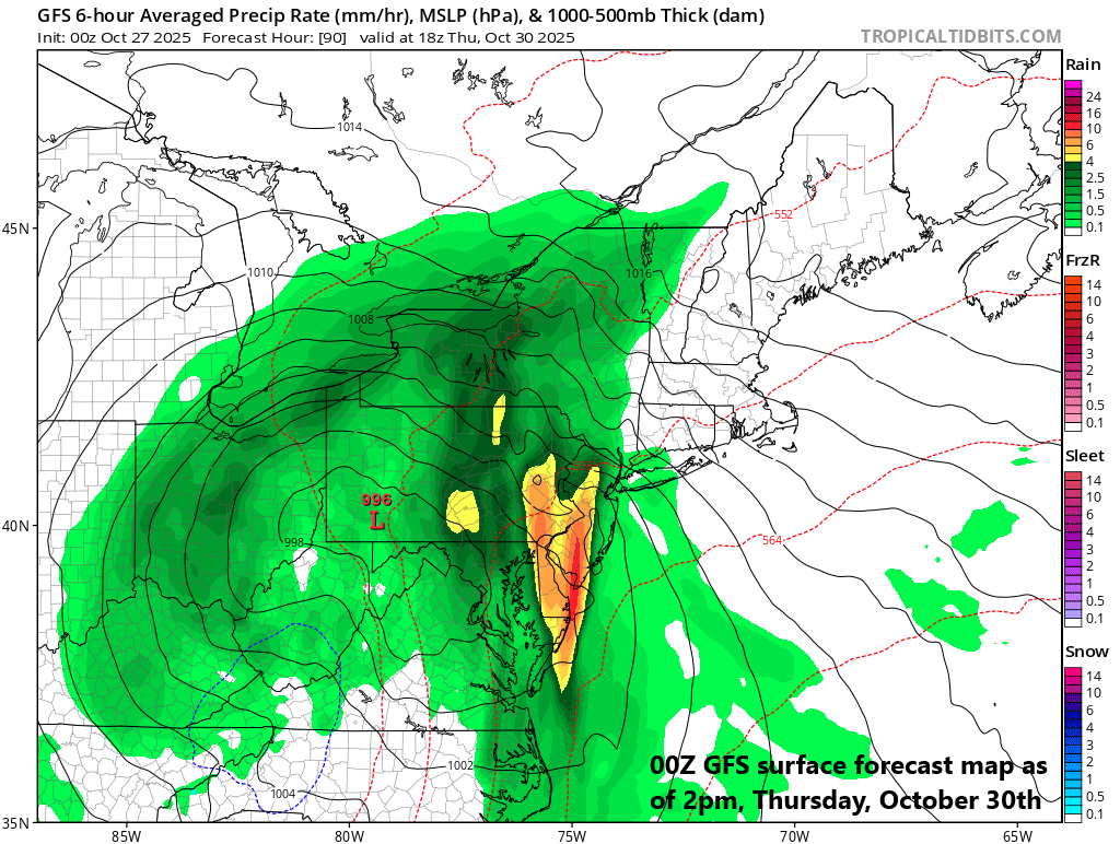
Rain can be heavy at times on Thursday in the Mid-Atlantic region and there can be embedded thunderstorms as well. Map courtesy NOAA, tropicaltidbits.com
Winds will also be a noticeable factor in the Mid-Atlantic region during this upcoming soaking rain event. Given the combination of strong high pressure to the north and the incoming storm from the Tennessee Valley, strong onshore winds are likely to develop by Thursday which can result in some coastal flooding at times of high tide.
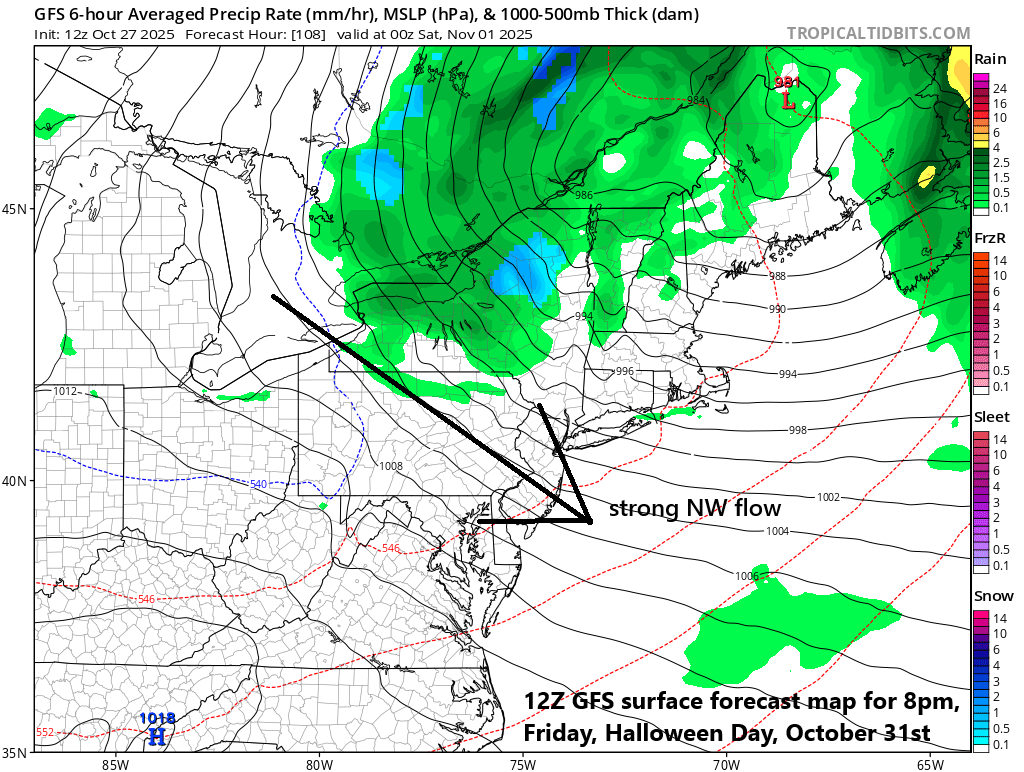
The winds will be howling on Halloween Day (Friday) on the back side of a departing strong storm system. Map courtesy NOAA, tropicaltidbits.com
Following the departure of the storm on Friday (Halloween Day), the winds will shift to a west-northwest direction and become quite strong. Temperatures will be quite cool as well on Friday with highs confined to the low-to-mid 50’s in many Mid-Atlantic locations to close out the work week.
Meteorologist Paul Dorian
Arcfield
arcfieldweather.com
Follow us on Facebook, Twitter, YouTube
Video discussion: