
***Low pressure to intensify over the western Atlantic Ocean this weekend...a threat to the coastal Carolinas and potentially to the Mid-Atlantic/Northeast US***
Paul Dorian

Wind gusts could become quite significant along coastal sections of the eastern seaboard by early next week with the potential development of a strong western Atlantic low pressure system. Map courtesy ECMWF, Weather Bell Analytics (Meteorologist Joe Bastardi, X)
Overview
Low pressure is likely to rapidly intensify this weekend over the southwestern Atlantic Ocean and it is a threat for heavy rainfall and strong winds along coastal sections of the Carolinas and potentially to the Mid-Atlantic/Northeast US. Whether this system becomes a named tropical storm is too early to say; however, the effects could be the same along parts of the eastern seaboard…namely with heavy rainfall and strong winds likely in the Saturday night to Monday time period. Some of the key players involved include strong high-pressure ridging which will set up over southeastern Canada and a cold front which will slide to the southwestern Atlantic Ocean later in the week and help to act as a catalyst for the intensification of low pressure.
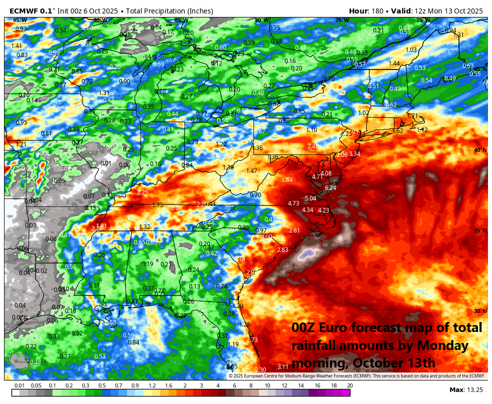
Rainfall amounts could be significant by next Monday morning (October 13th) due to a combination of the mid-week cold frontal passage and the potential weekend/early week strong western Atlantic Ocean low pressure system. Map courtesy ECMWF, Weather Bell Analytics (Meteorologist Joe Bastardi, X)
Details
Odds are increasing for the development of a strong low-pressure system over the southwestern Atlantic Ocean this weekend which could produce heavy rainfall and strong winds in the coastal Carolinas and potentially to the Mid-Atlantic/Northeast US. It is too early to say whether this system would qualify for named tropical storm status, but the effects could be the same with that threat of heavy rain and strong winds along parts of the eastern seaboard.

Two key players to the potential east coast mischief later this weekend and early next week will be strong high pressure ridging positioned over southeastern Canada and a strong trough of low pressure centered over the Mid-Atlantic coastline. Map courtesy NOAA, tropicaltidbits.com
A couple of the key players involved in this scenario will include a strong cold front that slides across the Mid-Atlantic/NE US by mid-week and then building high pressure into southeastern Canada by week’s end. This cold front is likely to bring some welcomed rainfall to the Mid-Atlantic region and Northeast US from later tomorrow night into Wednesday with the big cities along the I-95 corridor likely to receive 0.5 to 1.0 inches of rain.

The latest satellite image of the southwestern Atlantic Ocean features a large complex of showers and thunderstorms (circled region). This is the area to watch during the next several days as low pressure is likely to intensify here by the weekend after a frontal boundary zone slides into the region. Image courtesy NOAA/GOES-East
By late in the week, this same frontal system will slide to the southwestern Atlantic and stall-out there creating favorable environmental conditions for low pressure to intensify. As a result of the “frontal-induced” low pressure intensification, this system may not “qualify” to become a named tropical storm by NOAA’s National Hurricane Center, but that is something to be determined by the weekend or early part of next week. With the strengthening low pressure over the western Atlantic Ocean later this weekend combined with building high pressure over southeastern Canada, onshore flow is likely to intensify markedly and become an important factor along the Carolina coastline and potentially northward into the Mid-Atlantic region and Northeast US as well.
Stay tuned on this weekend/early next week threat along portions of the eastern seaboard...still several days to go….the time period of concern would be Saturday night into Monday.
Meteorologist Paul Dorian
Arcfield
arcfieldweather.com
Follow us on Facebook, Twitter, YouTube
Video discussion: