
***Low pressure to intensify significantly this weekend near the Southeast US coastline...heavy rain/strong winds on tap for the Carolinas and potentially northward to the Mid-Atlantic region***
Paul Dorian
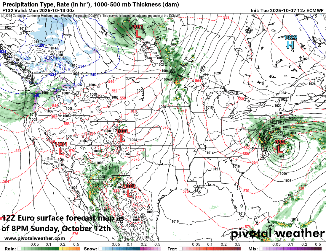
The latest run of the European forecast model (at 12Z) features a strong storm system just off the Mid-Atlantic coastline by Sunday evening. Map courtesy ECMWF, Pivotal Weather
Overview
Low pressure is going to intensify significantly this weekend near the Southeast US coastline, induced by a frontal boundary zone that slides into the region. It appears quite certain that this strong storm will then push far enough to the north to pound away at the coastal Carolinas with heavy rainfall and strong winds. It is a little less certain if this strong storm can then extend far enough to the north along the eastern seaboard to produce heavy rainfall and strong winds in the Mid-Atlantic region, but that scenario is certainly on the table. Whether this system becomes a named tropical storm by NOAA’s National Hurricane Center is still too early to say; however, the effects could be much the same along coastal sections of the Carolinas and potentially to the Mid-Atlantic region...namely with heavy rainfall and strong winds...a kind of classic autumnal Nor’easter. Some of the key players involved include strong high-pressure ridging which will set up over southeastern Canada and a cold front that will slide to the southwestern Atlantic Ocean by the end of the week and help to act as a catalyst for the significant intensification of surface low pressure.
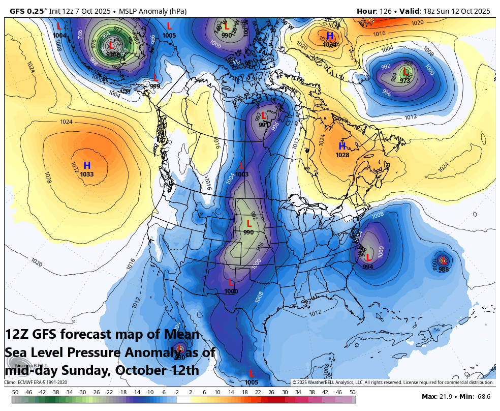
A key player this weekend will be strong high pressure over southeastern Canada (orange) to go along with strong surface low pressure near the Carolina coastline. Map courtesy NOAA (GFS), Weather Bell Analytics
Details
Odds are increasing for the development of a strong low-pressure system this weekend near the Southeast US coastline which is likely to produce heavy rainfall and strong winds in the coastal Carolinas and potentially to the Mid-Atlantic region. It is too early to say whether this unfolding low-pressure system would qualify for named tropical storm status as it will be “frontal-induced”, but the effects could be the same with that threat of heavy rainfall and strong winds along many coastal sections of the eastern seaboard.

Rainfall amounts could be heavy this weekend/early next week from the Carolinas to the Mid-Atlantic region. Map courtesy NOAA (GFS), Weather Bell Analytics
A couple of the key players involved in this scenario will include a strong cold front that slides across the Mid-Atlantic/Northeast US by later tomorrow and then building high pressure into southeastern Canada by week’s end. This cold front is likely to bring some beneficial rainfall to the Mid-Atlantic region and Northeast US from later tonight into the day on Wednesday with the big cities along the I-95 corridor likely to receive 0.5 to 1.0 inches of rain.
By late in the week, this same frontal boundary zone will slow down as it edges into the southwestern Atlantic Ocean/SE US coastal region, and it’ll help to strengthen low-level convergence...all favorable for the intensification of surface low pressure. As a result of the “frontal-induced” low pressure intensification, this system may not “qualify” to become a named tropical storm by NOAA’s National Hurricane Center, but that is something to be determined by the weekend or early part of next week. With the strengthening low pressure system near the east coast combined with building high pressure over southeastern Canada, onshore flow is likely to intensify markedly this weekend and become an important factor along the Carolina coastline...and potentially northward into the Mid-Atlantic region as well.
Stay tuned on this weekend/early next week threat along the east coast...still several days to go…time period of concern for the Mid-Atlantic will be Saturday night to Monday.
Meteorologist Paul Dorian
Arcfield
arcfieldweather.com
Follow us on Facebook, Twitter, YouTube
Video discussion: