
****Frontal boundary zone to act as a catalyst for a powerful weekend coastal storm...high impact expected in the coastal Carolinas and increasingly likely in the eastern Mid-Atlantic****
Paul Dorian
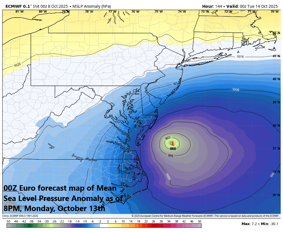
The 00Z Euro model run features strong low pressure located off the Mid-Atlantic coastline as of Monday evening, October 13th. This forecast is suggestive that this could be a long-lasting event in the Mid-Atlantic with impact possible as early as Saturday night and as late as Monday evening. Map courtesy ECMWF, Weather Bell Analytics (Meteorologist Joe Bastardi, X)
Overview
Low pressure is going to intensify significantly this weekend near the Southeast US coastline, induced by a frontal boundary zone that slides into the region. It appears quite certain that this strong storm will then push far enough to the north to pound away at the coastal Carolinas with heavy rainfall and strong winds...another highly impactful event for the Outer Banks of North Carolina. After that, odds continue to increase that this weekend storm system will then push to the northern Mid-Atlantic coastline - act as a classic Nor’easter - and bring impactful rain and wind to coastal sections for an extended period of time. By early next week, the northward progress of this storm system will likely come to an end as strong high pressure builds across southeastern Canada (“confluence”) acting as a barrier in the atmosphere. As a result, the storm should turn east or it may even loop back around for awhile early next week near the Mid-Atlantic coastline before ultimately pushing out to the open waters of the western Atlantic.

The 00Z Euro model run featured impactful wind gusts along coastal sections of the Carolinas and Mid-Atlantic region from this upcoming storm event. Map courtesy ECMWF, Weather Bell Analytics (Meteorologist Joe Bastardi, X)
Details
Odds continue to rise for the development of a strong low-pressure system this weekend near the Southeast US coastline, and this is likely to become another highly impactful event for the coastal Carolinas and potentially to the eastern Mid-Atlantic region. This unfolding low-pressure may not qualify for named tropical storm status due in part to it being a “frontal-induced” system, but the overall effects could be much the same with the threat of heavy rainfall and strong winds along many coastal sections of the eastern seaboard...let’s just call it a classic autumnal Nor’easter.

The 00Z Euro model run featured heavy rainfall amounts along coastal sections of the Carolinas and Mid-Atlantic region from this upcoming storm event. Map courtesy ECMWF, Weather Bell Analytics (Meteorologist Joe Bastardi, X)
One of the key players involved in this setup for the upcoming weekend event is a cold frontal system that today is sliding from northwest-to-southeast across the Mid-Atlantic region and Northeast US. This frontal boundary zone will end up over the southwestern Atlantic Ocean by the early part of the weekend and it’ll help to strengthen low-level convergence in that area which is favorable for the development of surface low pressure. This low-pressure system will then intensify and push slowly northward, likely reaching the coastal sections of the Carolinas by later Saturday night/early Sunday morning producing heavy rainfall and strong winds...another highly impactful event for the Outer Banks of North Carolina.

This forecast map of 500 mb height anomalies as of Saturday evening features some of the key players involved in this weekend scenario. First, strong high pressure ridging will set up over southeastern Canada (orange area). Second, an upper-level trough will drop southeast across the Great Lakes and it’ll have an impact on both the strength and path of the coastal low pressure system. Finally, a trough of low pressure will setup over the coastal region of the Southeast US associated with our strong surface low. Map courtesy NOAA (GFS), tropicaltidbits.com
By the late weekend and early part of next week, this strong coastal low-pressure system will become influenced by two other key players in this unfolding pattern including strong high pressure ridging over southeastern Canada and an upper-level low pushing to the southeast across the Great Lakes. This combination is likely to cause the strong low-pressure system to eventually grind to a halt in its northward progress, but likely not before it reaches the northern Mid-Atlantic by later Sunday night/early Monday. With the “blocking” pattern setting up in the atmosphere by the late weekend, the storm system may be forced to take a turn to the east or it could even cause the system to loop back around. This “blocking” action aloft may extend the high impact time period for heavy rainfall and strong winds in the eastern Mid-Atlantic region all the way from Saturday night to at least mid-day Monday…in other words, a long period of onshore flow raising the chance for beach erosion and coastal flooding in many areas.
Stay tuned on this weekend strong coastal storm threat...still a few questions to answer.
Meteorologist Paul Dorian
Arcfield
arcfieldweather.com
Follow us on Facebook, Twitter, YouTube
Video discussion: