
***Accumulating snow from Saturday night into Sunday morning…bitter cold, strong winds to follow for the rest of Sunday, Sunday night, and Monday***
Paul Dorian
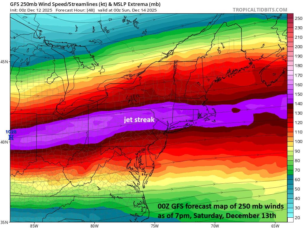
A key player on Saturday night/early Sunday will be a powerful upper-level jet streak overhead in the Mid-Atlantic region. This will enhance upward motion in the Mid-Atlantic region and contribute in an important way to the first plowable snowfall along the DC-to-Philly-to-NYC corridor. Map courtesy NOAA, tropicaltidbits.com
Overview
The next in a series of Arctic air masses will begin to plunge into the north-central states later today and this one will be brutal...potentially the worst of the bunch since the cold pattern developed around Thanksgiving Day. Temperatures this weekend can drop to 20 degrees below zero in parts of the region from Montana to Wisconsin and wind chills can reach dangerously low levels. Meanwhile, yet another “clipper” system will begin to organize later today out across the north-central states and then push east-southeast on Saturday crossing over central Plains, Midwest and Ohio Valley. This system will reach the Mid-Atlantic region on Saturday night and will be supported aloft by a vigorous jet streak that will enhance upward motion in the area. The result will be accumulating snow from Saturday night into Sunday morning in the Mid-Atlantic region and this includes the DC-to-Philly-to-NYC corridor. Bitter cold and strong winds will follow for the rest of Sunday, Sunday night, and Monday.
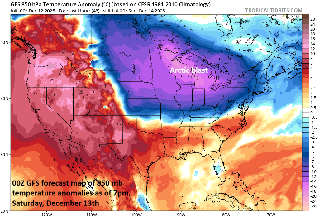
The overall weather pattern has been cold since Thanksgiving Day and yet another Arctic air mass will invade the US from Canada over the next few days. This air mass will be noteworthy as temperatures could fall to twenty degrees below zero in many spots and wind chills can reach dangerously low levels. Map courtesy NOAA, tropicaltidbits.com
Details
The next in a series of “clipper” systems will produce some accumulating snow today out across the Midwest and Ohio Valley, but it will weaken upon its approach into the Mid-Atlantic region. As a result, the DC-to-Philly-to-NYC corridor will likely see little to no snow today and skies will be partly sunny. Out across the north-central states, another Arctic air mass will push in later today from southern Canada and this one will be brutal...perhaps the worst of all since this cold pattern got cranking around Thanksgiving Day. Temperatures could drop to twenty degrees below zero across portions of Montana, Minnesota, and Wisconsin this weekend and wind chills will become dangerously low in many areas. Look for numerous record or near record low temperatures from the Northern Plains to the Great Lakes/Midwest early in the weekend and that threat of record-breaking cold may shift to the northeastern states by the end of the weekend and early part of next week.

With strong support aloft, low pressure is likely to intensify near the Mid-Atlantic coastline by early Sunday paving the way for some accumulating snow along the DC-to-Philly-to-NYC corridor. Map courtesy Canadian Met Centre, tropicaltidbits.com
Yet another “clipper” system will begin to take shape later today with the influx of Arctic air in the north-central US and then head in an east-to-southeast direction on Saturday crossing over the central Plains, Midwest and Ohio Valley…this system is the one that can bring the first plowable snow to portions of the Mid-Atlantic’s I-95 corridor later this weekend. When this system arrives in the Mid-Atlantic region on Saturday night, it looks like it will have quite a bit of upper-level support with a powerful jet streak moving overhead that will enhance upward motion in the area. The result is likely to be accumulating snow from Saturday night into Sunday morning in the Mid-Atlantic region and this should include the I-95 corridor region from DC-to-Philly-to-NYC. Current snowfall estimates are as follows with a general starting time of 9pm (Saturday) to 1am (Sunday):
DC metro: 1-3 inches with localized higher amounts
Philly metro: 2-4 inches with localized higher amounts
NYC metro: 2-4 inches with localized higher amounts
northern DE to central NJ: 3-6 inches with localized higher amounts
Notes - the precipitation can begin briefly as a mix of rain, sleet, and snow in some areas on Saturday evening before changing to all snow…localized higher amounts are possible due to the expectation of “mesoscale” heavier snow bands to form in this pattern
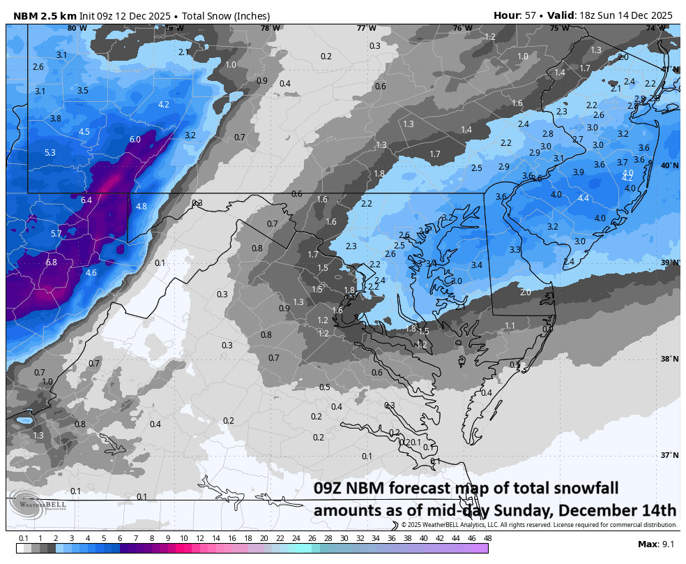
Accumulating snow should fall in the DC-to-Philly-to-NYC corridor from Saturday night into Sunday morning. This forecast map of snow totals comes from the National Blend of Models (NBM) as of 09Z Friday. Map courtesy NOAA, Weather Bell
Following the snow, Arctic air will flood the Mid-Atlantic region and the rest of Sunday, Sunday night, and Monday will feature strong, biting winds and bitter cold. The Arctic chill that arrives on Sunday in the northeastern states will stick around into Tuesday with well below normal temperatures for mid-December. Looking ahead, there is likely some noticeable warming on the way for the latter part of next week across the northeastern states.
One final note, football games on Sunday will certainly be affected by this next Arctic air outbreak with very windy and cold conditions expected in Philly (1pm, Eagles vs Raiders) and New York City (1pm, Giants vs Commanders) and especially in Chicago where the Bears play the Browns at 1pm and temperatures will struggle to pass much above the ten degree mark for afternoon highs...btw, only 59 days until spring training.
Meteorologist Paul Dorian
Arcfield
arcfieldweather.com