
10:45 AM | ****Arctic chill dominates the scene...Mid MS Valley-to-southern Mid-Atlantic snowstorm...some snow likely DC-to-Philly-to-NYC corridor...not done yet with the cold air outbreaks****
Paul Dorian

The current Arctic chill extends all the way to the east coast from the Rocky Mountain States and has resulted in numerous daily low temperature records across the Northern Plains where wind chills of 50 degrees below zero have been commonplace. Map courtesy NOAA, tropicaltidbits.com
Overview
Arctic chill dominates the scene today across much of the eastern two-thirds of the nation and will continue to do so during the next few days. Indeed, there were numerous daily low temperature records set this morning with a focus on the north-central states (e.g., Glasgow, MT; Bismarck, ND; Duluth, MN) where wind chills of 50 degrees below zero have been commonplace. In addition to the cold, the wintry pattern will result in a snowstorm during the next couple of days that will first hit the Middle Mississippi Valley region (e.g., northern Arkansas/southern Missouri) and then extend to the southern Mid-Atlantic region (e.g., southeastern VA, Delmarva Peninsula). There can even be some snow in the DC-to-Philly-to-NYC corridor from later tomorrow into Thursday as low pressure intensifies off the coast and a northern stream upper-level low passes overhead creating an unstable environment...small accumulations are possible. Looking ahead, though temperatures will relax later this weekend into early next week, there are signs that additional Arctic cold air outbreaks will impact the central and eastern states as we close out the month of February and begin March.

The cold has been extreme across the Northern Plains and there were numerous daily low temperature records set this morning. One such example took place in Bismarck, North Dakota where temperatures bottomed out at -38 degrees (F) besting the old record that was set in 1910. Map courtesy coolwx.com, NOAA
Details
When you are breaking record low temperatures in places like Bismarck, North Dakota and Duluth, Minnesota then you are very likely dealing with an extremely cold air mass and indeed, that is the case today across the Northern Plains where wind chills of 50 degrees below zero have been commonplace. In Bismarck, the temperature dropped to -38°F besting the old record of -37°F set in 1910 and this was their lowest temperature during the month of February since 1994 (credit Chris Martz (X)). This Arctic chill will continue across much of the central and eastern states for the next few days and this wintry weather pattern will produce a snowstorm as well that will impact the region from the Middle Mississippi Valley to the southern Mid-Atlantic.

Significant accumulating snow will fall from the Middle Mississippi Valley region to the southern Mid-Atlantic between late tonight and early Thursday with some spots possibly receiving as much as a foot of snow. Map courtesy NOAA, tropicaltidbits.com
Low pressure will begin to organize late tonight over the northern Gulf region, and it will have plenty of available moisture to tap into. In the cold sector of the storm system, snow will break out by early tomorrow and several inches of accumulation are possible across places like northern Arkansas and southern Missouri. This system will then push in an east-northeast direction and likely reach the waters off the Carolina coastline by early Thursday morning. Accumulating snow is likely from later tomorrow into Thursday morning across the southern Mid-Atlantic region including southeastern Virginia and the southern half of the Delmarva Peninsula where some spots can receive as much as a foot of snow. Some specific cities that can receive significant accumulating snow from this mid-week system include Richmond, Norfolk and Virginia Beach in the state of Virginia, and Salisbury in the state of Maryland.

The northern jet stream wave of energy (circled area) will pass overhead of the DC-to-Philly-to-NYC corridor on Thursday likely resulting in quite an unstable atmosphere. This should result in snow shower activity or perhaps even a period of steadier snow and small accumulations are on the table in the immediate I-95 corridor. Map courtesy NOAA, tropicaltidbits.com
At this point, it appears the low pressure system will continue to push in an east-northeast direction and rapid intensification is likely to take place out over the open waters of the western Atlantic Ocean when a southern stream wave of energy phases with a northern stream system. With the rapid intensification of the surface low holding off until it is out over the open waters of the western Atlantic Ocean and given the storm’s path well to the southeast of the I-95 corridor, the chance for significant snowfall in the immediate DC-to-Philly-to-NYC corridor region is low. However, that is not the end of the story as far as the chances go for some accumulating snow in the immediate I-95 corridor.

The tropospheric polar vortex will drop to a position near the Hudson Bay region of Canada by later next week and its associated upper-level trough will extend all the way down to the southeastern US. Map courtesy NOAA, Weather Bell Analytics
At the same time low pressure is intensifying rapidly off the coast, the vigorous wave of energy in the northern jet stream will pass right overhead of the Mid-Atlantic on Thursday and this will enhance upward motion and produce quite unstable conditions. As a result, there is likely to be snow shower activity or even some steadier snow in the DC-to-Philly-to-NYC corridor from later tomorrow into Thursday and small accumulations of a coating to a couple of inches cannot be ruled out. On the heels of the low pressure, another windy and very cold day is coming to the Mid-Atlantic region on Friday, but temperatures should modify by the latter part of the weekend and the early part of next week.
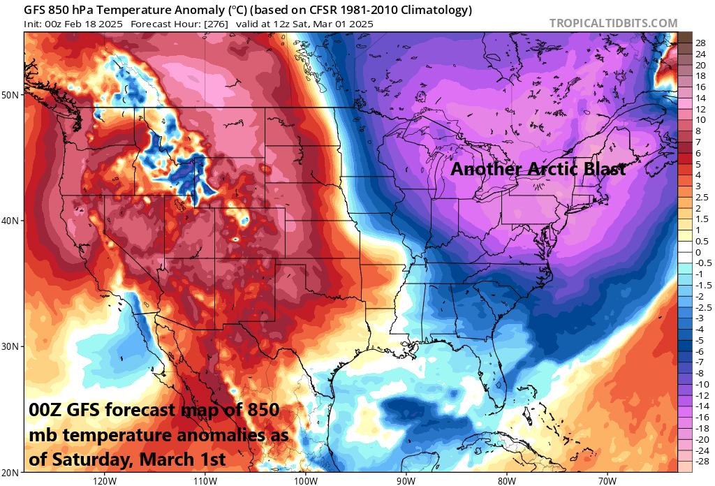
The Arctic air mass that currently encompasses much of the eastern two-thirds of the nation will modify by the latter part of the weekend, but there are signs of additional cold air outbreaks as we close out the month of February and begin March. This forecast map for the 1st of March features much colder-than-normal air across the Great Lakes, Mid-Atlantic and Northeast US. Map courtesy NOAA, tropicaltidbits.com
Looking ahead, there are signs that additional Arctic air outbreaks may be destined to reach the central and eastern states. The tropospheric polar vortex is likely to drop into the Hudson Bay region of Canada by late next week and its associated deep upper-level trough may extend all the way through the eastern US. This kind of upper air pattern would be quite favorable for the influx of cold air masses from northern Canada into the central and eastern US as we close out the month of February and begin the new month of March.
Meteorologist Paul Dorian
Arcfield
arcfieldweather.com
Follow us on Facebook, Twitter, YouTube
Video discussion: