
11:15 AM (Thursday) | ***”The cold is getting old, but it just won’t fold”...a look ahead to early March and the likelihood for more cold air outbreaks***
Paul Dorian

The average temperature across the continental US earlier today was some 15 degrees below normal and some spots were around 50 degrees below the average for this time of year. Map courtesy NOAA, weathermodels.com (Dr. Ryan Maue, (X))
Overview
Arctic air covers much of the nation again today with a continuing tight grip on the central states where numerous daily low temperature records have been set all the way from the Dakotas to Texas and, in a few cases, monthly low temperature records have been challenged. The average temperature across the continental US earlier today was 15.0°F below the average for this time of year and, in a few spots, temperatures were between 45 and 50 degrees below the average (e.g., Nebraska, SW Missouri). Temperatures will gradually moderate over the upcoming weekend and next week promises to feature above-normal temperatures across a wide part of the nation. It is, however, quite likely that additional very cold air masses will be able to make their way from northern Canada into the central and eastern US as the month of March gets underway.

The last couple of mornings have featured numerous record or near record low temperatures for the date in the area from the Dakotas-to-Texas. It is likely that tomorrow morning will also feature numerous record-challenging temperature readings including along the Gulf coastal region from Texas-to-Florida. Map courtesy coolwx.com, NOAA
Details
There was a widespread area across the nation this morning that suffered through record or near record low temperatures with a focus on the central states and I would expect numerous spots early tomorrow to approach or break daily low temperature records including areas along the Gulf coast and Mississippi Valley. One example of today’s impressive cold took place in Wichita, Kansas where the low temperature of -13 degrees (F) tied the record set in 1889 for the coldest ever recorded this late in their winter season (credit Ryan Maue). The upcoming weekend will (finally) feature a warming trend across the Plains as west-to-southwest winds help to bring milder air down the Rockies to the center part of the nation.
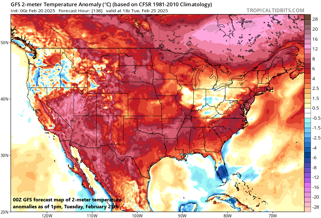
A warming trend gets underway this weekend and virtually the entire nation will feature above-normal temperatures by Tuesday of next week. This does not, however, look like a long-lasting change to spring-like weather for the central and eastern states as additional cold air masses are destined to move in for the early part of March. Map courtesy NOAA, tropicaltidbits.com
In the eastern states, temperatures will slowly moderate this weekend and then the warming will intensify during the first half of next week. In fact, by the time we get to Tuesday of next week, temperatures should be above-normal across much of the US with only a few pockets left featuring colder-than-normal conditions (perhaps Florida as an example). Next week’s warm-up, however, does not appear to be part of a large-scale change in the upper-air pattern that will leave us with spring-like conditions from here on out. Indeed, there are signs that point to additional cold air outbreaks for the central and eastern US as we end February and begin the new month of March.

The tropospheric polar vortex is expected to move southward by late next week to a position over the Hudson Bay region of Canada and from there, an upper-level trough will extend all the way into the southeastern US…a wintry looking pattern for the central and eastern US as we begin the month of March. Map courtesy ECMWF, Weather Bell Analytics (Meteorologist Joe Bastardi (X))
By late next week, the tropospheric polar vortex looks likely to drop south to a position over the Hudson Bay region of Canada and from there it can act as a source of cold air for the central and eastern states. An upper-level trough of low pressure looks like it’ll extend all the way from the polar vortex centered over the Hudson Bay to the southeastern US, and this overall pattern has a rather wintry look to it for the central and eastern states right at the time the calendar flips from February to March.

With the tropospheric polar vortex dropping into the Hudson Bay region of Canada late next week, the likelihood for cold air outbreaks into the central and eastern US will rise for the early part of March. Map courtesy ECMWF, Weather Bell Analytics (Meteorologist Joe Bastardi (X))
Indeed, some longer-range forecast models suggest some very cold air may drop into the northeastern quadrant of the country by the early part of March encompassing the Great Lakes, Mid-Atlantic, and Northeast US. Whether or not a storm can form during this upcoming wintry pattern in the eastern states remains to be seen and there are some early signs of something late next week or early in March. But for now, overall confidence is higher in the prediction of a colder-than-normal temperature pattern rather than any storminess that might come along. And it appears more and more likely that Punxsutawney Phil may have had the right idea in his prediction of six more weeks of winter...at least in the central and eastern states…never a doubt in my fellow Pennsylvania prognosticator.
Meteorologist Paul Dorian
Arcfield
arcfieldweather.com
Follow us on Facebook, Twitter, YouTube
Video discussion: