***Severe weather threat later today/tonight focused on Minnesota, Wisconsin, Iowa and Illinois...additional cold air outbreaks and severe weather threats into early May***
Paul Dorian

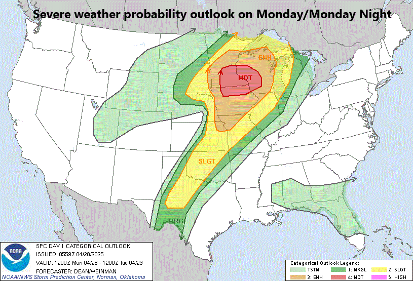
Severe weather is likely later today and tonight with the highest probability across the Upper Midwestern states of Minnesota, Wisconsin, Iowa and Illinois. Strong tornadoes are on the table as well as large hail and swaths of damaging wind gusts. Map courtesy NOAA’s Storm Prediction Center
Overview
There have been numerous colder-than-normal air masses in recent weeks pushing into the central and eastern US from Canada and also into the western US from the eastern Pacific Ocean. The continuing influx of these colder-than-normal air masses along with an active jet stream has led to numerous severe weather outbreaks in recent weeks. Indeed, severe weather is likely later today and tonight with a focus on the Upper Midwestern states of Minnesota, Wisconsin, Iowa and Illinois though some severe thunderstorm activity can extend all the way south and west to the south-central states of Texas and Oklahoma. The overall pattern that has produced these occasional cold air and severe weather outbreaks in the US looks quite likely to last at least into the first part of May with a risk next Monday and Tuesday in the nation’s mid-section.

Numerous ingredients will come together later today and tonight likely resulting in a regional severe weather outbreak across the Upper Midwest including a strong vorticity maximum (circled area) which will help to enhance upward motion across Minnesota, Wisconsin, Iowa and Illinois. Map courtesy NOAA, tropicaltidbits.com
Monday/Monday Night severe weather threat
Ingredients are coming together for a severe weather outbreak later today and tonight including possible tornadoes with the strongest likelihood across the Upper Midwestern states of Minnesota, Wisconsin, Iowa and Illinois. Strong and intensifying surface low pressure will move from South Dakota to eastern Minnesota by early tonight and it will have a dryline extending southwestward all the way to the Texas Panhandle.

Numerous ingredients will come together later today and tonight likely resulting in a regional severe weather outbreak across the Upper Midwest including a strong jet streaks at both the lower-level (left) of the atmosphere and upper-level (right) which will help to enhance upward motion across Minnesota, Wisconsin, Iowa and Illinois. Map courtesy NOAA, tropicaltidbits.com
This surface system will have plenty of upper-level support with jet streaks in multiple parts of the atmosphere moving into this part of the country. In addition, as has been customary in recent weeks, cold, dry air will be advancing from the north and west into warmer and more humid air to the south and east setting up the “battle zone” region across the Upper Midwest later today into tonight. This combination of ingredients will enhance upward motion across the Upper Midwest and multiple severe thunderstorms are likely to form from later today into tonight with a regional severe weather outbreak possible including the potential of strong tornadoes. Large hail and swaths of damaging wind gusts are on the table as well from later today into tonight.
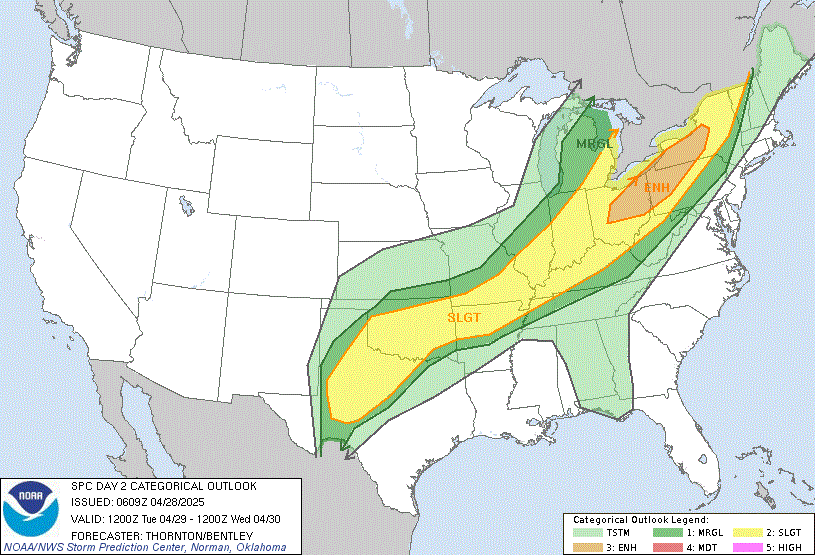
Though not as high of a risk as later today, there will a threat of severe weather later tomorrow and tomorrow night primarily focused on the region from the eastern Great Lakes to western sections of the Mid-Atlantic and Northeast US. Map courtesy NOAA’s Storm Prediction Center
Tuesday/Tuesday Night severe weather threat
The threat of severe weather will slide to the south and east later tomorrow and tomorrow night and the greatest chance for strong-to-severe thunderstorm activity will likely be from the eastern Great Lakes to western sections of the Mid-Atlantic and Northeast US (e.g., northwestern PA, western NY). As far as the DC-to-Philly-to-NYC corridor is concerned, it appears the upper-level support will lose much of its punch by the time the system reaches the eastern seaboard on Tuesday night so expect showers only and perhaps a “conventional” thunderstorm or two, but certainly this situation will need to be monitored closely.

Possible severe weather threat next Monday/Tuesday across the nation’s mid-section
Looking ahead, another cold air outbreak is likely to push from Canada across the Great Lakes region later in the week reaching the Mid-Atlantic/Northeast US on Saturday. And yet another colder-than-normal air mass is likely to push eastward this weekend from the eastern Pacific Ocean to the western states. This kind of scenario could very well help to spawn a severe weather outbreak in the nation’s mid-section around next Monday and/or Tuesday (May 5th-6th) across the nation’s mid-section from Texas to Nebraska with the familiar clash between cold, dry air to the west and warm, humid air to the east....not quite done with the cold air and severe weather outbreaks.
Meteorologist Paul Dorian
Arcfield
arcfieldweather.com
Follow us on Facebook, Twitter, YouTube
Video discussion: