Tuesday AM - **Tropical moisture flowing right into the Mid-Atlantic region...active, wetter pattern continues to alleviate dry conditions in the eastern states...more cold air outbreaks**
Paul Dorian

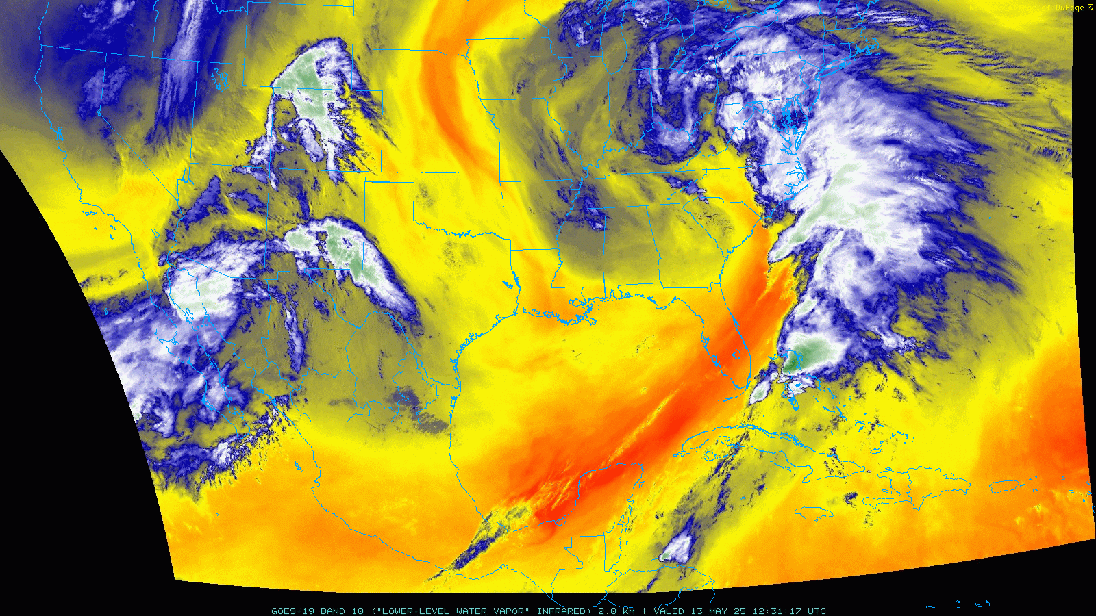
Tropical moisture in the lower atmosphere is flowing northward today into the Mid-Atlantic region (shown in blue/white) from the southwestern Atlantic. Dry air (shown in orange/yellow) can be seen across Florida and much of the Gulf region in addition to the central US. Maps courtesy NOAA, College of DuPage
Overview
It has been unusually dry across much of the Mid-Atlantic region during the past several months, but prospects for getting back to normalcy are looking better and better in what has become an overall wetter weather pattern. In fact, today features an impressive plume of tropical moisture that is flowing right into the Mid-Atlantic region from the southwestern Atlantic Ocean and beneficial rain is falling in most areas. This widespread area of moisture is supported aloft by a vigorous and slow-moving upper-level trough of low pressure and, as such, the threat of showers and thunderstorms will continue through Thursday. After a brief lull in the action later this week, another low pressure system will head towards the Great Lakes and it’ll renew the threat of showers and thunderstorms in the Mid-Atlantic region from later Friday into Saturday. This active weather pattern looks likely to continue through the remainder of the month of May and there will be additional cold air outbreaks as well including potentially one for the Mid-Atlantic region during the Memorial Day weekend.

Soaking and welcome rain is currently falling today from the Carolinas to the Mid-Atlantic region and the southeastern US received some beneficial rainfall on Monday. The heaviest rainfall amounts during the next few days in the Mid-Atlantic’s I-95 corridor will be on the southwest side (i.e., D.C. metro region) and least amounts on the northeast side (i.e., NYC metro region). Maps courtesy weatherunderground.com, WSI, Intellicast
Details
Most recent months in the Mid-Atlantic region have been drier-than-normal going back to last fall when the month of October was especially dry and featured virtually no rainfall in some spots such as Philadelphia, PA. Lately, we have begun to significantly chip away at the dry soil conditions in the Mid-Atlantic region with an extended wet period last week and it looks like a repeat performance this week in the Tuesday to Thursday time frame.

Yet another slow-moving upper-level trough of low pressure is playing a big role in the weather pattern across the eastern US. This system currently sits over the Tennessee Valley region and it’ll finally “open up” and spin off to the north and east by later in the week. Looking ahead, the active pattern will continue with additional deep troughs in the US and cold air outbreaks are not quite done yet as well. Map courtesy NOAA, tropicaltidbits.com
There is currently an impressive plume of tropical moisture that is feeding into the Mid-Atlantic region from the southwestern Atlantic Ocean and soaking (and welcome) rain is falling all the way from the Carolinas to the northern Mid-Atlantic. This large area of moisture is supported aloft by yet another very slow-moving and deep upper-level trough (“omega blocking pattern”) now centered over the Tennessee Valley. While it won’t be a constant rain, showers will be a threat in the DC-to-Philly-to-NYC corridor right through Thursday thanks to the very slow-movement of the system aloft and thunderstorms can mix into the picture as well. The heaviest rainfall amounts during this Tuesday to Thursday stretch in the Mid-Atlantic’s I-95 corridor will be on the southwest side (i.e., D.C. metro area) and least total rainfall amounts on the northeast side (i.e., NYC metro area). Once the upper-level low finally “opens up” and exits off to the north and east during the late week, there can be a brief break in the action; however, more rain is to follow quickly on its heels.

Most months between now and last fall have featured below-normal rainfall for much of the eastern US, but we have been chipping away at these dry soil conditions with recent rain events and this wetter, active pattern looks likely to continue through the remainder of the month of May. Map courtesy NOAA
Low pressure will develop over the Great Lakes by the end of the week and it’ll push at least a couple of frontal systems this way from later Friday into Saturday. The low and its associated frontal systems will renew the shower threat in the Mid-Atlantic region from later Friday into Saturday and there can be some strong-to-severe thunderstorm activity as well. Drier air finally pushes into the area for the Sunday/Monday time frame, but more rain threats are sure to follow later next week. In fact, this active weather pattern looks likely to continue through the remainder of the month of May and there will be additional cold air outbreaks as well including one potentially for the Mid-Atlantic region during the Memorial Day weekend.

The overall weather pattern will likely remain quite active right through the remainder of the month of May and there will be additional cold air outbreaks as well. In fact, there is the potential of a chilly Memorial Day weekend in the Mid-Atlantic after the possible arrival of a colder-than-normal air mass into the region. Map courtesy ECMWF, tropicaltidbits.com
Meteorologist Paul Dorian
Arcfield
arcfieldweather.com
Follow us on Facebook, Twitter, YouTube
Video discussion: