
**Chipping away at the dry conditions in the eastern US...a couple bouts of rain this week...additional threats ahead**
Paul Dorian
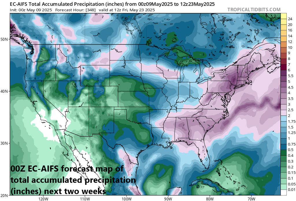
There is much hope in continuing to alleviate the drought conditions across the eastern US during the next couple of weeks with multiple rain events on the table. Map courtesy ECMWF, tropicaltidbits.com
Overview
It has been unusually dry across much of the eastern US during the past several months with a focus on the Florida Peninsula, but we have been chipping away at these conditions in recent weeks and there are likely to be additional beneficial rainfall events during the new couple of weeks. Rain is falling today throughout much of the Mid-Atlantic region and Northeast US – the second bout of rain this week – and rain is currently falling across portions of the northern Gulf region. This area of Gulf moisture will push east during the next few days and then take a turn to the north early next week and ride up slowly along the Atlantic seaboard. As a result, it appears there will be more beneficial rainfall in the Mid-Atlantic region and Northeast US from later Tuesday into Thursday further alleviating the dry conditions and additional rain threats exist later this month in an on-going active pattern.

Most months between now and last fall have featured below-normal rainfall for much of the eastern US, but we have been chipping away at these dry soil conditions with recent rain events and more rain is on the way during the next couple of week. Map courtesy NOAA
Details
Most months have featured below-normal precipitation amounts in the Mid-Atlantic region going back to last fall with the month of October in 2024 an especially dry month highlighted by virtually no rainfall in many spots. Lately, we have begun to chip away at the dry soil conditions in the Mid-Atlantic region though it has been somewhat sporadic in that some areas have received quite a bit more than other nearby locations. For example, the difference in rainfall through yesterday has been rather significant from southeastern PA to east-central PA with around a quarter of an inch in Philly for the month and around 3 inches in Allentown. Today’s rainfall should turn out to be quite beneficial (and more uniform) across all of eastern PA including the Philly metro region.

The second bout of rain this week in the Mid-Atlantic/NE US is thanks in large part to an upper-level low that formed overhead during the past 24 hours or so. This system aloft has combined with a slow-moving surface cold front to produce some beneficial rainfall to this part of the nation and more is likely to come by the middle of next week. Map courtesy ECMWF, tropicaltidbits.com
After this current rain event winds down, high pressure will produce a dry weekend and early part of next week in the Mid-Atlantic region, but more welcome rainfall is on the way just beyond. An area of moisture across the northern Gulf states will push slowly eastward through the weekend and then take a turn to the north early next week. As a result, rain is likely to return to the Mid-Atlantic region around late Tuesday and given the slow-moving nature of this system, the rain threat can continue into Thursday of next week...all good news in the chipping away at the dry conditions in this part of the nation.

An upper-level trough of low pressure now over the central Gulf region will slowly edge eastward during the next few days and then take a turn to the north early next week. As a result, more rain is likely coming to the Mid-Atlantic region in the Tuesday-to-Thursday time frame which would help in the chipping away at dry soil conditions across the eastern US. Map courtesy ECMWF, tropicaltidbits.com
Looking ahead, there are signs that the overall active weather pattern will continue well into the second half of the month of May. Signs point to the potential of yet another vigorous (and slow-moving) upper-level trough to make its way into the eastern US by the third full week of May (19th-23rd). This kind of system could bring additional beneficial rainfall to the eastern states which would alleviate further dry soil conditions around here. The potential downside to this on-going active weather pattern containing deep upper-level troughs is that it can also result in additional severe weather outbreaks across the central and eastern...perhaps threats late next week and potentially continuing into that third full week of the month.

Our continuing active weather pattern could result in yet another deep upper-level trough of low pressure over the eastern states during the third full week of May (19th-23rd) and this certainly can bring more beneficial rainfall to the eastern states. On the downside, this kind of pattern can also bring about more in the way of severe weather outbreaks for the central and eastern states as we progress through the month of May. Map courtesy ECMWF, tropicaltidbits.com
Meteorologist Paul Dorian
Arcfield
arcfieldweather.com
Follow us on Facebook, Twitter, YouTube
Video discussion: