
*Hot, humid pattern from Friday into mid-week...next week’s pattern conducive to "MCCs"...an August preview...pleasant start...ramp up in tropical activity...MJO update*
Paul Dorian

The Madden-Julian Oscillation (MJO) may move into favorable locations (or “phases”) during the early part of August for tropical activity to ramp up in the Atlantic Basin. In addition, “climatology” argues that tropical activity should ramp up in August based on the usual still-increasing sea surface temperatures. Map courtesy NOAA, Australia Weather Centre
Overview
Heat and humidity will increase today in the Mid-Atlantic region and temperatures should reach well into the 90’s on Friday along the I-95 corridor. It stays very warm and humid this weekend and through the first half of next week. In terms of prospects for rain, an approaching frontal system late tomorrow will increase the chance of showers and thunderstorms; especially, on the NW side of I-95. This front stalls out this weekend nearby and the result will be the threat of showers and thunderstorms from time-to-time.
Looking ahead, the pattern changes noticeably by later next week across the northeastern states with an upper-level trough of low pressure intensifying over southeastern Canada. Comfortable air is likely to drop south and east from Canada into the Northeast US and Mid-Atlantic region late next week and the first several days of August might be rather pleasant. It is at this time that conditions might change in the tropical Atlantic Ocean which can lead to a ramp up in activity by the middle of the new month and a teleconnection index (MJO) supports this notion.
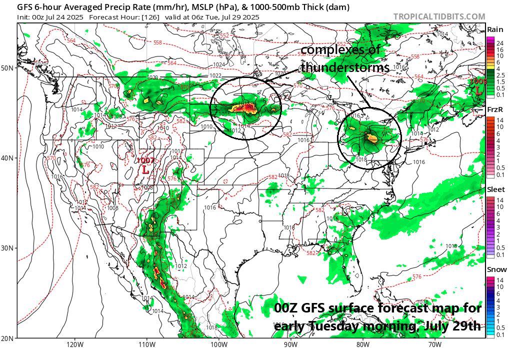
By the early and middle parts of next week, strong upper-level ridging will become centered over the TN Valley/south-central US and there will be broad northwest flow of air on its northern side from the Northern Plains to the northeastern states. This kind of pattern often feature complexes of thunderstorms known as “Mesoscale Convective Complexes (MCCs)” to develop which would travel from northwest-to-southeast in the northwest flow…something to monitor next several days. Map courtesy NOAA, tropicaltidbits.com
Hot, humid through mid-week...”MCC” threat in northwest flow
Hot and humid weather makes a return to the northeastern states on Friday with temperatures likely climbing well up into the 90’s from DC-to-Philly-to-NYC-to-Boston. A frontal system will drop slowly from northwest-to-southeast on Friday and into the northeastern part of the nation raising the chance for late day and evening showers and thunderstorms. The pattern remains unsettled this weekend as the front stalls out in close proximity with a daily chance of showers and thunderstorms to go along with hot and humid conditions.

A pattern change by late next week can lead to rather pleasant weather conditions from the end of July though early August across much of region from the central/northern Plains to the Mid-Atlantic/NE US. Map courtesy NOAA, tropicaltidbits.com
The upper-level pattern next week will feature strong high pressure ridging over the south-central states and a northwest flow of air on its northern side from the Northern Plains to the Northeast US. This kind of pattern sometimes produces complexes of thunderstorms known as “Mesoscale Convective Complexes (MCCs)” that travel in the northwest flow from the Great Lakes/Midwest to the Mid-Atlantic/Northeast US. It is too early to pinpoint the exact timing and location for these type of thunderstorm complexes, but it is something to monitor during the next few days for the first half of next week. Later next week, strong Canadian high pressure will show up in south-central Canada and it will gradually build to the south and east. As a result, pleasant air is likely to push into the Great Lakes, Midwest, Northeast US and Mid-Atlantic region late next week and the first part of August may feature rather pleasant weather conditions.
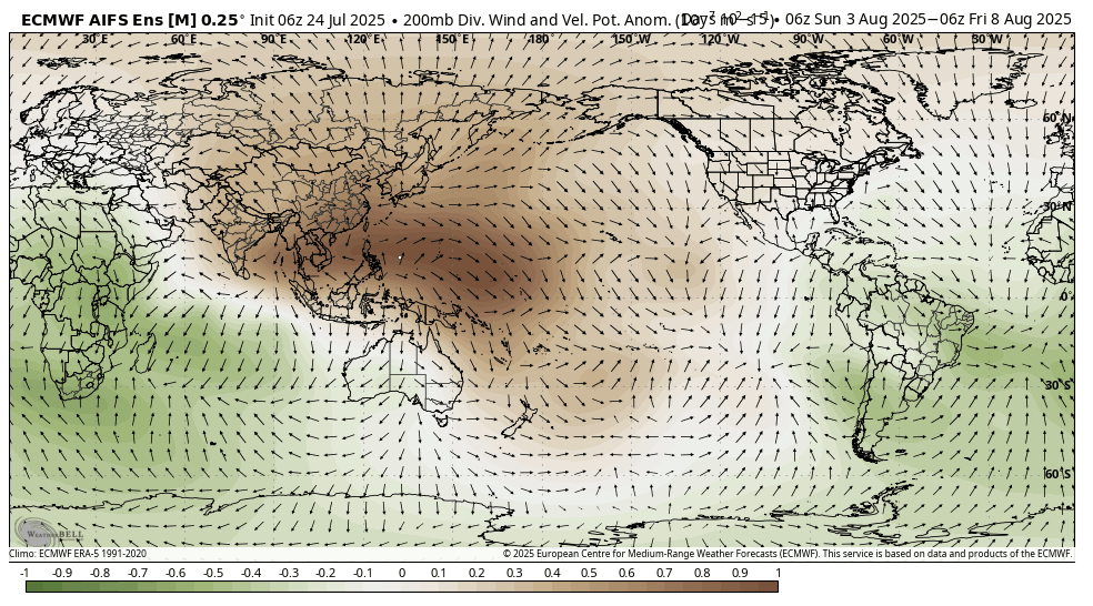
The overall pattern in the upper atmosphere come early August looks like one that will feature divergence aloft (shown in green) over the Atlantic Basin which will be correlated with convergence in the lower levels. This kind of pattern will lead to enhanced upward motion in the Atlantic Basin which, in turn, should lead to a ramp up in activity by mid-month. Map courtesy ECMWF, Weather Bell Analytics (Meteorologist Joe Bastardi)
Tropical talk
During the month of August, the Atlantic Basin tropical season – which has been relatively quiet so far – typically ramps up in activity and a teleconnection index known as the Madden-Julian Oscillation is sending signals that support this notion. The expected location (phases 8 and 1) of a tropical disturbance during the first part of August is likely to lead to enhanced upward motion in the Atlantic Basin which, in turn, is likely to lead to a ramp up in activity by the second or third week of the new month.
Meteorologist Paul Dorian
Arcfield
arcfieldweather.com
Extended video discussion on the “MCC” threat, August preview, MJO, SST update, and possible implications on the upcoming winter season: