
***An update on Tropical Storm Erin...the “curve away from the east coast” scenario still holds in general, but closely monitoring as nothing is written in stone this far out***
Paul Dorian
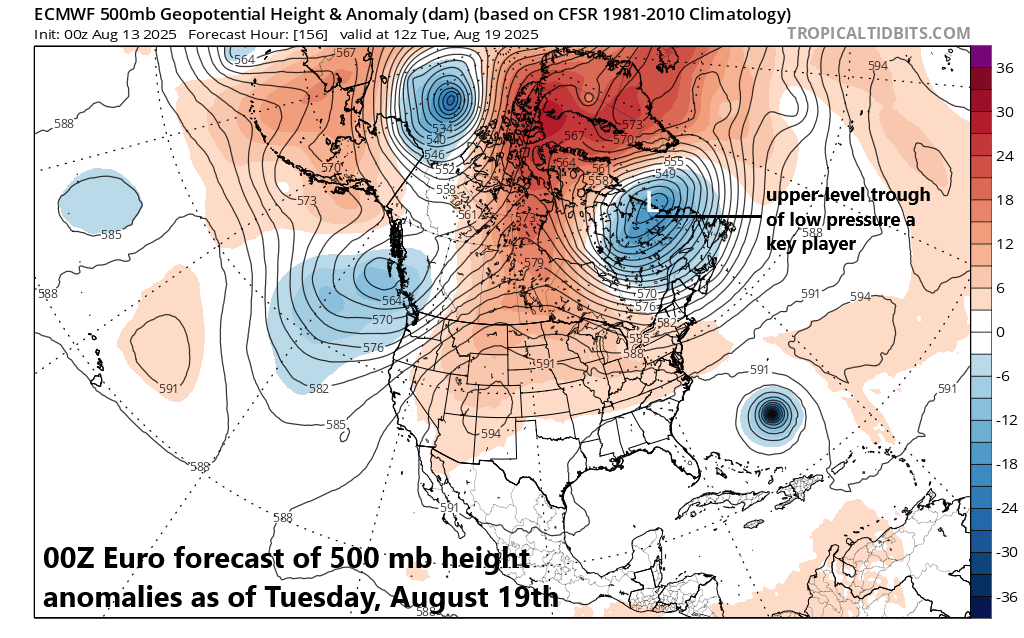
A key player in the ultimate path of Tropical Storm Erin will be a strong trough of low pressure that can form over southeastern Canada by early next week. This system would likely aid in the curve of Erin away from the US east coast and to a position out over the North Atlantic. Map courtesy ECMWF, tropicaltidbits.com
Overview
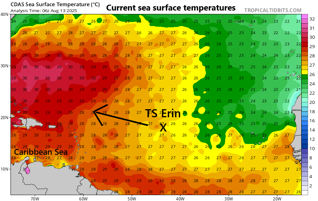
The intensity of Tropical Storm Erin has been relatively unchanged during the past 24 hours maintaining maximum sustained winds of around 45 mph as it churns to the west across the tropical Atlantic. There is not likely to be much intensification over the next 24 hours or so as it continues to deal with a dry air mass and moves over only modestly warm waters. Later this week, TS Erin will push over increasingly warm water in the western Atlantic Ocean and this will very likely result in intensification to category 1 hurricane status...the first hurricane of the 2025 Atlantic Basin tropical season.
Over the weekend, overall environmental conditions will become more favorable for intensification as it moves over very warm water and this can result in Erin attaining “major” hurricane status of category 3 (or higher). It is at this time that the overall flow aloft should allow for Erin to begin a curve to the north over the western Atlantic Ocean and then ultimately to the northeast…likely resulting in it not reaching the US east coast. However, there are several days to go and this system needs to be closely monitored as nothing is written in stone this far out.

Dry air that pushed westward from northern Africa (Sahara Desert region) currently surrounds Tropical Storm Erin and has inhibited its chances for intensification. The overall environmental conditions should become more favorable for intensification by week’s end and during the early weekend as Erin pushes past the dry air mass and moves over increasingly warmer waters of the western Atlantic Ocean. Map courtesy University of Wisconsin/CIMSS
Details
Tropical Storm Erin formed early this week in the eastern Atlantic Ocean and it has held rather steady in its intensity during the past few days with persistent maximum sustained winds of around 45 mph. Significant intensification is not likely during the next 24 hours either as Tropical Storm Erin will continue to encounter a dry air mass that pushed westward into the tropical Atlantic from the Sahara Desert region of northern Africa. In addition, TS Erin will move in the near-term over water that features only marginal sea surface temperatures with respect to intensification prospects. However, by the end of the week, TS Erin will be pushing over increasingly warm water with sea surface temperatures that are well up in the 80’s and overall environmental conditions will become more favorable for intensification. As a result, Erin may reach category 1 hurricane in 48 hours or so and then it could actually climb to “major” hurricane status over the upcoming weekend (i.e., category 3 or higher).
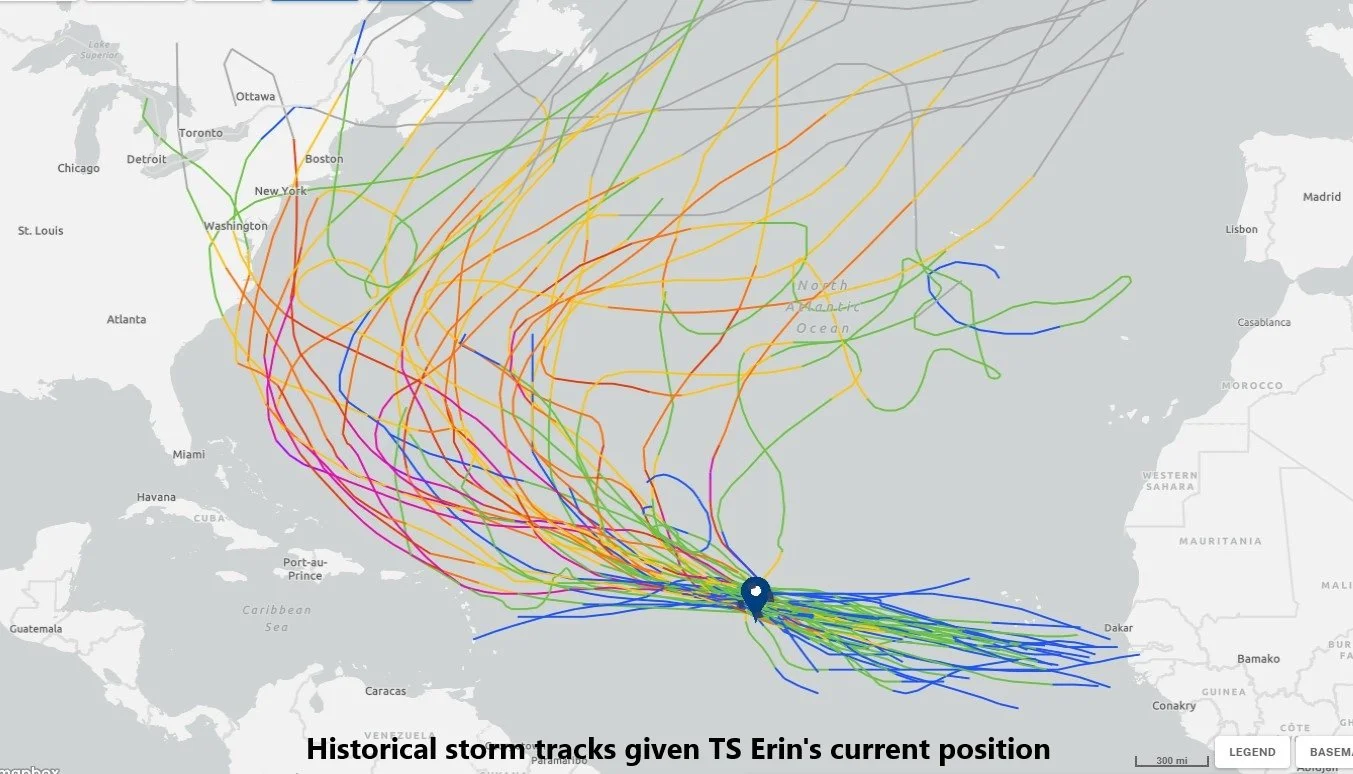
This plot shows historical tracks of tropical cyclones that were in similar locations as is Tropical Storm Erin. In the vast majority of cases, these systems curved away from the US east coast and that is the current expectation for TS Erin, but there are still several days to go with this event. Plot courtesy Meteorologist Bernie Rayno (Accu-Weather, X)
Over the weekend, high pressure ridging in the upper part of the atmosphere will be centered over the northeastern US/southeastern part of Canada, but it is likely to give way to a deepening trough of low pressure by the early part of next week. This trough of low pressure would likely have an increasing influence on the path of Erin probably causing it to curve away from the US east coast before it ever reaches there. Ultimately, Erin could end up pushing through the North Atlantic to near Greenland or Iceland potentially resulting in copious amounts of snow in that part of North America.
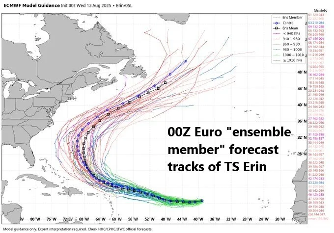
Odds continue to favor a “curve away from the east coast” scenario for Tropical Storm Erin during the early-to-middle parts of next week as a strong upper-level trough of low pressure is likely to form over southeastern Canada. However, there are still several days to go before this event and this system needs to be closely monitored. Map courtesy ECMWF
Hopefully, the “curving away from the east coast” idea will continue to hold, and we’ll continue to closely monitor the situation as there are several days to go and nothing is yet written in stone. One of the things that can change the current expectation of a “curving away” path by TS Erin is its forward speed. If this system slows down over the weekend, it could end up in a different overall upper air pattern than currently expected. One final note, even if the tropical system stays away from the US east coast, it certainly can still produce rip currents, high surf, and stiff winds along some coastal sections by the early-to-middle parts of next week…stay tuned.
Tropical Storm Erin will soon push over increasingly warm waters of the tropical Atlantic Ocean supporting intensification into hurricane status by week’s end (i.e., category 1) and then potentially to “major” classification later this weekend (i.e., category 3 or higher). Map courtesy NOAA/NHC
Meteorologist Paul Dorian
Arcfield
arcfieldweather.com
Follow us on Facebook, Twitter, YouTube
Video discussion: