
***Tropical Storm Erin to undergo significant and rapid intensification taking it to "major" hurricane status this weekend...likely to curve away from the east coast at mid-week***
Paul Dorian

Tropical Storm Erin has been moving over modestly warm water during the past couple of days, but water temperatures underneath will rise considerably later in the weekend when Erin reaches the southwestern Atlantic Ocean. The increasingly warm water will combine with more favorable atmospheric conditions (less dry air, less wind shear) to allow for significant and rapid intensification of Erin which can take it from tropical storm status to “major” hurricane classification later this weekend. Map courtesy NOAA, tropicaltidbits.com
Overview
Tropical Storm Erin appears better organized today and has indeed undergone a bit of strengthening with maximum sustained winds now clocked at 60 mph as it churns to the west at around 17 mph. Over the next few days, Tropical Storm Erin will push over increasingly warm waters of the southwest Atlantic Ocean and atmospheric conditions will become more favorable for intensification (less dry air, less wind shear). As a result, significant and rapid intensification is on the table for Erin which could take it from its current tropical storm status to hurricane (category 1) classification on Friday and then to “major” hurricane status (category 3 or higher) on Saturday. It is at this time that the overall flow aloft should allow for Erin to begin a curve away from the east coast …first to the northwest then to the north and ultimately to the northeast and out over the open waters of the North Atlantic. Two key players in this expected curve of Erin will be an upper-level ridge over eastern Canada that will tend to get displaced by an upper-level trough of low pressure...all of these systems still need to be closely monitored as small changes can potentially have big impacts on some coastal sections.
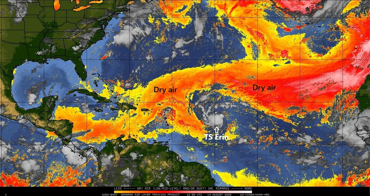
Tropical Storm Erin is surrounded by dry air that had its origins over the Sahara Desert region of Africa and this air mass has inhibited its intensification during the past couple of days (and will for the next 24 hours or so). Early this weekend, the center of Erin will move into an environment with less dry air allowing for significant and rapid intensification. Map courtesy University of Wisconsin/CIMSS
Details
Tropical Storm Erin formed early this week in the eastern Atlantic Ocean and - after holding relatively steady in its strength during the past few days - it has strengthened some during the past 12-24 hours with maximum sustained winds now clocked at 60 mph. Tropical Storm Erin will move over increasingly warm waters of the southwestern Atlantic Ocean during the next few days and atmospheric conditions will become more favorable for intensification as overall wind shear should relax near its circulation center and dry air should lessen. As a result, Erin may undergo significant and rapid intensification from its current “tropical storm” classification to a category 1 hurricane on Friday and then to “major” hurricane status (category 3 or higher) later Saturday.
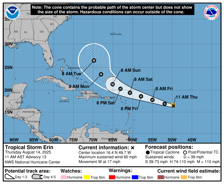
Tropical Storm Erin continues to churn to the west at 17 mph and now has maximum sustained winds of 60 mph. Erin will push over increasingly warm waters of the southwestern Atlantic Ocean during the next few days and this combined with more favorable atmospheric conditions (less wind shear, less dry air) will allow for substantial intensification to “major” hurricane status. Map courtesy NOAA/NHC
The latter part of the weekend should feature high pressure ridging over eastern Canada that will then tend to weaken and be displaced by an upper-level trough of low pressure. This transition should allow Erin to begin a curve by early next week - first to the northwest then to the north and finally to the northeast – likely resulting in no direct impact to the US east coast. Eventually, Erin should end up over the North Atlantic potentially producing some snow in Greenland or Iceland during the latter part of next week. If this curve away from the east coast does indeed take place – and odds continue to favor this scenario – there still can be some indirect impacts along the east coast with rip currents, rough surf, and stiff winds of 40 mph or so on the table.
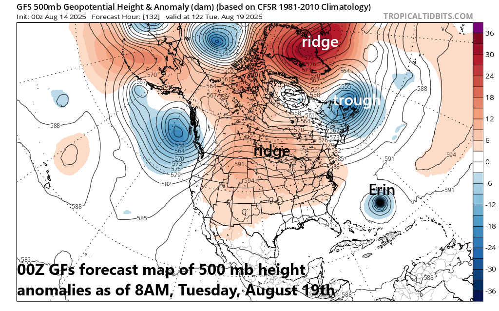
Two key factors to monitor in coming days will be an upper-level ridge over the eastern part of Canada and an upper-level trough that will tend to displace the ridge…the movement and interaction of these two upper-level systems will impact greatly the ultimate path of Erin. Map courtesy NOAA, tropicaltidbits.com
In terms of what can change this still-anticipated “curve away from the east coast” scenario, focus will be on the movement and interaction of the upper-level ridge and trough over eastern Canada as well as the forward speed of Erin. If, for example, Erin were to slow down this weekend then that could allow time for the upper-level trough of low pressure to push away from eastern Canada into the North Atlantic potentially leading to upper-level ridging re-forming in that area. This kind of a change aloft from current expectations could possibly allow Erin to push farther to the west (and closer to the east coast) before any “curving” takes place. Given there are still several days to go before the “curve” of Erin materializes, the overall situation has to be closely monitored for potential last-minute changes…small deviations can potentially have big impacts along some portions of the east seaboard…stay tuned.
Meteorologist Paul Dorian
Arcfield
arcfieldweather.com
Follow us on Facebook, Twitter, YouTube
Video discussion: