
***Hurricane Erin to curve away from east coast next few days...significant impact in the Outer Banks...rip currents, high surf along much of east coast with beach erosion/coastal flooding***
Paul Dorian

Hurricane Erin is a “major” category 4 storm with maximum sustained winds of 140 mph and is moving to the west-to-northwest at around 10 mph. Images courtesy NOAA/GOES-East
Overview
Erin has strengthened today and is now a category 4 “major” hurricane with maximum sustained winds of 140 mph and is moving to the west-northwest at around 10 mph. Hurricane Erin will begin a turn to the northwest later today followed by a general turn to the north from Tuesday into Wednesday and then it’ll begin an acceleration on Thursday and take a sharp turn to the northeast.
Even though the center of Hurricane Erin will remain offshore as it curves away from the east coast, its strength, expansion in size, and the prolonged nature of an onshore flow of air will likely result in significant impact to the Outer Banks of North Carolina where beach and coastal damage may be extreme. Elsewhere along the east coast, rip currents and high surf are likely along many coastal sections and there is likely to be beach erosion and coastal flooding with a prolonged period of onshore flow.

Tropical storm force winds from Hurricane Erin are likely along the Outer Banks of North Carolina where mandatory evacuations have already begun (Hatteras and Ocracoke Islands) and hurricane-force gusts are on the table. Map courtesy NOAA/NHC
Details
Hurricane Erin underwent significant and rapid intensification late last week climbing from tropical storm status early Friday to category 5 “major” hurricane classification by late Saturday. The movement of Erin over increasingly warm waters of the southwestern Atlantic Ocean late last week, and its escape from the dry (Sahara Desert) mass that had enveloped it, unleashed the intensification process which became rapid and significant. After that, Hurricane Erin did weaken rather rapidly; however, it has regained some of that lost strength today and is currently classified as a strong category 4 “major” hurricane with maximum sustained winds of 140 mph. While it can continue to intensify for awhile longer, a return to category 5 status may be difficult with 157+ mph winds a required threshold to meet...not impossible, but rather a formidable challenge.
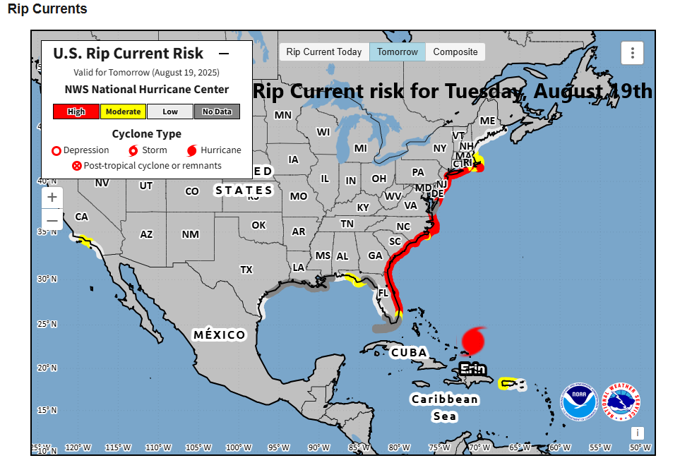
Rip currents are a high risk for the next few days along much of the eastern seaboard in addition to rough surf and beach erosion as a result of Hurricane Erin which curves away from the coast. Map courtesy NOAA/NHC
As upper-level ridging begins pull back from the northeast US over the next day or so, Hurricane Erin will begin its long-anticipated curve away from the east coast. A turn to the northwest can begin later today to be followed by a general northerly movement from tomorrow into Wednesday. After that, an upper-level trough of low pressure over the northwestern Atlantic Ocean will help to accelerate Hurricane Erin and turn it sharply to the northeast from Thursday into Friday. By the early part of the weekend, the remnants of Erin will be positioned out over the open waters of the North Atlantic and it’ll be headed over cooler and cooler waters.

Waves will become quite high along much of the eastern seaboard during the next few days as “major” hurricane Erin passes by to the east. Map courtesy NOAA/NHC
While its center will remain offshore, Hurricane Erin is likely to have a significant impact on the Outer Banks of North Carolina where extreme beach and coastal damage may take place. Winds there are likely to reach at least tropical storm status - potentially hurricane-force - and remain so for a prolonged period of time and water spouts are a threat as well in this kind of environment. In addition, the size of Hurricane Erin is likely to increase over the next couple of days raising the chance of beach/coastal damage on its northwestern side out over the Outer Banks...mandatory evacuations are already taking place in Hatteras and Ocracoke Islands.
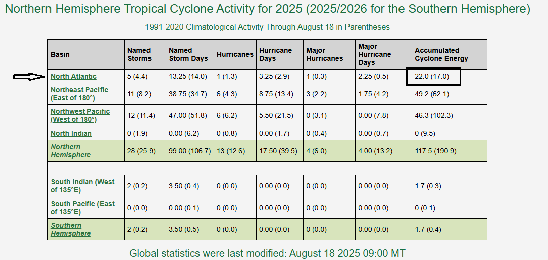
“Accumulated Cyclone Energy” is a useful metric to determine overall tropical activity and with the arrival of Erin, the ACE has climbed from below-normal to above-normal in the Atlantic Basin. The rest of the Northern Hemisphere remains below-normal for this stage of the tropical season with much quieter than normal conditions across the western Pacific Ocean. Table courtesy NOAA, Colorado State University
Onshore flow will be rather prolonged in other parts of the eastern seaboard as well potentially leading to beach erosion/coastal flooding. High pressure currently sits over southeastern Canada and an east-to-northeast flow of air has already stiffened up along the Northeast US/Mid-Atlantic coastlines. As this flow continues, the likelihood of rip currents and high surf will increase during the next few days and the threat of beach erosion/coastal flooding will continue. Onshore winds (east-to-northeast direction) will likely become their strongest (~40 mph possible) along the Mid-Atlantic coastline on Thursday at which time Hurricane Erin will pass by well to the east on its way to the open waters of the North Atlantic.

On the heels of Erin is another tropical system that has a good chance of becoming the sixth named tropical storm of the 2025 Atlantic Basin tropical season. Map courtesy NOAA/NHC
One final note, another tropical wave has exited off the west coast of Africa in recent days and it is currently positioned over the far eastern Atlantic Ocean. This system has an excellent chance of attaining named tropical storm status in coming days – would be the sixth of the 2025 season – and it could become an important player to deal in the eastern or southern US sometime later next week. The quiet start to the Atlantic Basin season has indeed quickly gone from well below-normal in terms of “accumulated cyclone energy” to above-normal and this particular metric which factors in both magnitude and longevity of tropical cyclones will climb markedly during the next several days as a result of Hurricane Erin and the next system on the way.
Meteorologist Paul Dorian
Arcfield
arcfieldweather.com
Follow us on Facebook, Twitter, YouTube
Video discussion: