***Hurricane Erin to curve away from east coast...recent weakening brings it down to category 2...Mid-Atlantic coastline impacted on Thursday...two other tropical systems...cool pattern to set up***
Paul Dorian

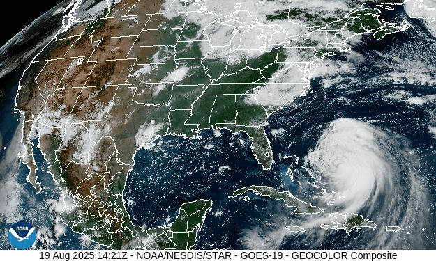
Hurricane Erin has weakened in recent hours, but it has also grown in size. As a result, its impact zone will extend well to the north and west of the core circulation center with the Outer Banks of North Carolina set to be affected on Wednesday and the Mid-Atlantic coastline will be buffeted by strong winds from late Wednesday night into Thursday. Images courtesy NOAA/GOES-East
Overview
Erin has weakened during the past 24 hours and has now lost its “major” hurricane status and is classified as a category 2 storm with maximum sustained winds of 105 mph. The long-anticipated curve of Erin has begun with a movement currently to the northwest at 9 mph to be followed by a northerly push on Wednesday and then an acceleration to the northeast on Thursday. While Erin has weakened in recent hours, it has also expanded in size and its outer perimeter winds are likely to reach tropical-storm force levels across the Outer Banks on Wednesday and potentially even to hurricane-force levels. Rip currents and rough surf will extend all the way up the eastern seaboard for the next couple of days and beach erosion/coastal flooding is on the table in many areas. The biggest impact along the Mid-Atlantic coastline will come later Wednesday night and Thursday with strong winds impacting coastal sections from Long Island-to-New Jersey-to-the Delmarva Peninsula.
Looking ahead, there are two other tropical systems now in the eastern Atlantic, and they’ll have to be monitored during the next several days...any impact from these two systems would be from next week into the following week which would take us into the early part of September. Also, a cooler-than-normal weather pattern looks like it’ll set up for much of the eastern half of the nation for the last week or so of the month of August once Hurricane Erin exits off to the open waters of the North Atlantic.

The long-anticipated curve away from the east coast of Hurricane Erin has begun today with a turn to the northwest from west. The general movement of Wednesday will be in a northerly direction and then an acceleration to the northeast will take place on Thursday. Map courtesy ECMWF, weathermodels.com
Details
Hurricane Erin has undergone weakening during the past 24 hours or so due to a combination of increased vertical wind shear and an encounter with some dry air. In addition, it is likely that a slow-down in its forward motion during the late night hours helped to create “upwelling” conditions underneath its circulation center which is a process that brings cooler waters from down below to the surface level. This surface-level cooling is an inhibiting factor for intensification and can contribute to overall weakening…at least on a temporary basis.
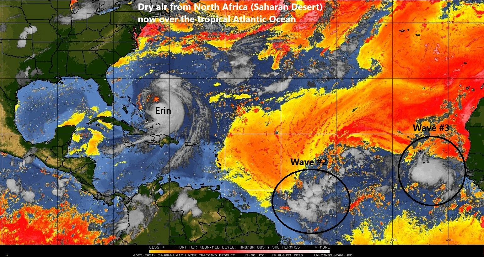
Hurricane Erin has weakened in recent hours, but is has also expanded in size which increases the chance for serious impact in the Outer Banks region of North Carolina. There are two other tropical systems now in the eastern Atlantic and both are currently in the vicinity of some dry air (shown in orange), but both have a chance of reaching named tropical storm status in coming days. Map courtesy NOAA, University of Wisconsin/CIMSS
While Erin has weakened in recent hours, it has broadened in size meaning its wind field is now encompassing a larger area and this is a problem for places like the Outer Banks of North Carolina. Hurricane-force winds now extend out 80 miles from the center and tropical-storm force winds out some 230 miles. In addition, it is possible that Hurricane Erin regains some strength in the near-term as the overall wind shear it has been dealing with during the past 24 hours or so will tend to diminish allowing for some re-intensification. While its center will remain offshore, Hurricane Erin is likely to have a rather significant impact on the Outer Banks of North Carolina on Wednesday where serious beach and coastal damage may take place. Winds there are likely to reach at least strong tropical storm status and given the expansion in its overall wind field and potential re-intensification, Erin could potentially produce hurricane-force wind gusts along the Outer Banks. Mandatory evacuations took place yesterday in Hatteras and Ocracoke Islands and Erin’s closest approach is likely to be later tomorrow.

The closest approach of Hurricane Erin to the Mid-Atlantic coastline is likely to come from late Wednesday night into Thursday and the winds can be quite strong along coastal sections from Long Island-to-New Jersey-to-the Delmarva Peninsula. Map courtesy NOAA, tropicaltidbits.com
The long-anticipated curve away from the east coast has begun with latest movement by Hurricane Erin being to the northwest at 9 mph (was down to 7 mph in the overnight hours) and its general movement on Wednesday will be in a northerly direction around the western periphery of high pressure centered near Bermuda. On Thursday, as an upper-level trough of low pressure pushes in from the northwest, Hurricane Erin will begin to accelerate to the northeast and likely end up over the open waters of the North Atlantic by later this weekend. It is quite common for tropical cyclones to accelerate once they reach higher latitudes as they become increasingly influenced by mid-latitude westerlies.
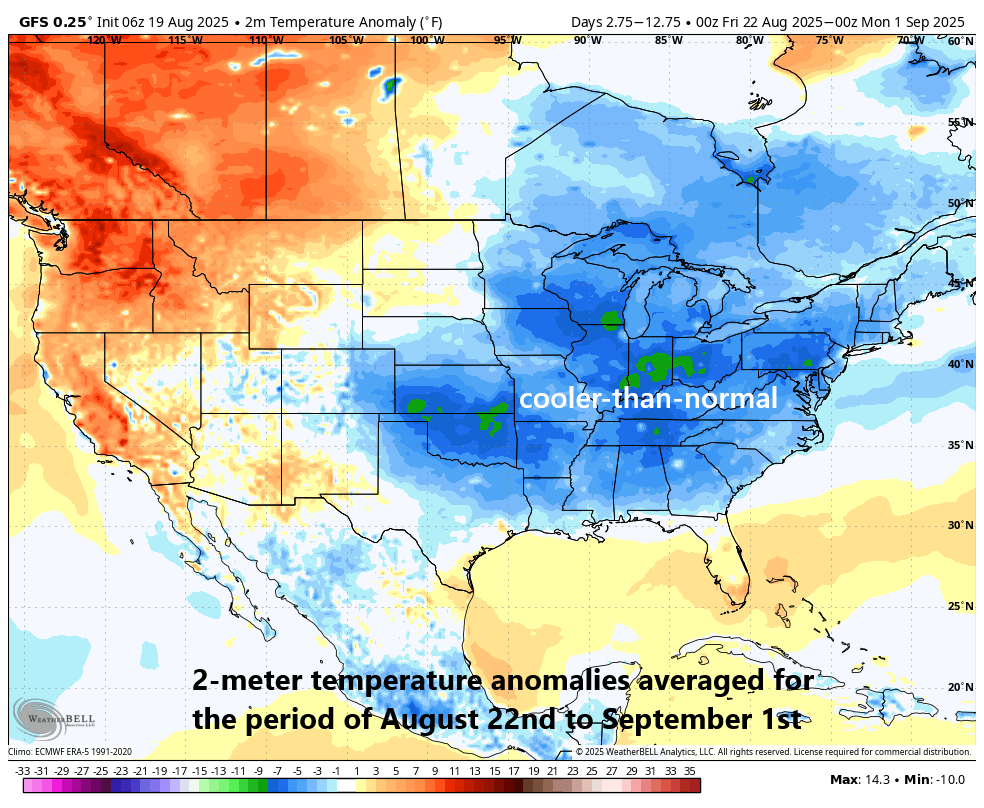
Once Hurricane Erin exits off to the northeast and out over the open waters of the North Atlantic, a cooler-than-normal weather pattern is likely to set up for much of the eastern half of the nation for the last week or so of the month of August. Map courtesy NOAA, Weather Bell Analytics (courtesy Meteorologist Joe Bastardi, X)
Despite the offshore position of Hurricane Erin, rip currents and rough surf have already developed along the North Carolina coastline and are spreading up along the eastern seaboard. As many as 50 swimmers had to be rescued on Tuesday at Wrightsville Beach, North Carolina due to the rip currents associated with the far-offshore Hurricane Erin. Rip currents and rough surf will continue to impact the east coast on Wednesday and Thursday and - given the prolonged period of onshore flow - there can be some beach erosion and coastal flooding along the Mid-Atlantic and Northeast US coastlines at times of high tide. The biggest impact along the Mid-Atlantic coastline is likely to come late Wednesday night and Thursday when strong winds can buffet the coastal sections from Long Island-to-New Jersey-to-the Delmarva Peninsula.
Looking past Hurricane Erin, there are now two other tropical waves that exist over the eastern Atlantic Ocean. Both of these waves have a decent chance of becoming named tropical storms in coming days as they trek westward across the tropical Atlantic Ocean (would be “Fernand” and “Gabrielle”). It is way too early to tell if the eastern or southern US will be impacted by either of these systems, but a rough timetable can be estimated for any potential impact and that would be from the middle of next week into the following week which takes us into the first part of September...stay tuned. And one final note, once Hurricane Erin departs off to the northeast and out over the North Atlantic, cooler-than-normal conditions are likely to follow for much of the eastern half of the nation during the last week or so of the month of August.
Meteorologist Paul Dorian
Arcfield
arcfieldweather.com
Follow us on Facebook, Twitter, YouTube
Video discussion: