**It’s August and the tropics heat up right on schedule across the Atlantic Basin...next few weeks looking active**
Paul Dorian

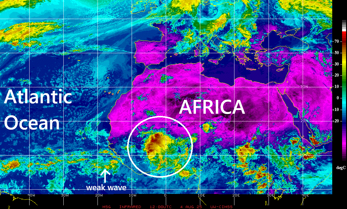
A colorized infrared satellite image of Africa features an impressive wave (circled) that is pushing westward towards the tropical Atlantic Ocean. This system will need to be closely monitored during the next couple of weeks as it crosses over the warm waters of the tropical Atlantic. Image courtesy NOAA, University of Wisconsin/CIMSS
Overview
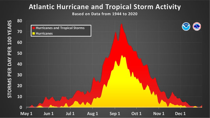
The Atlantic Basin tropical season typically reaches a peak around the middle of September and the month of August usually features a steady ramp up in overall activity. Indeed, adhering to the climatological theme, tropical activity has picked up in the Atlantic Basin right on schedule once we flipped the calendar from July to August, and it is featuring multiple systems. A teleconnection index known as the Madden-Julian Oscillation or MJO is providing support to the idea that the next few weeks will remain quite active in the Atlantic Basin.
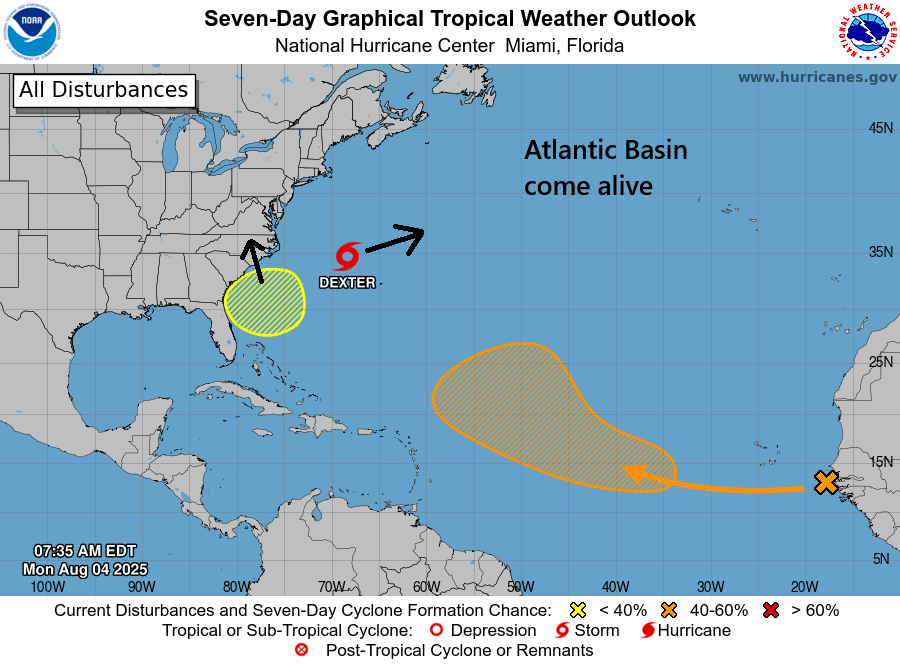
The calendar has flipped from July-to-August and the Atlantic Basin tropical activity has picked up markedly. Tropical Storm Dexter will push farther out-to-sea in coming days and a wave just off the US Southeast coast may strengthen into tropical storm status (yellow hatched area). Whether or not this system reaches tropical storm status, it is likely to push ample amounts of moisture into the Carolinas later this week and potentially, into the Mid-Atlantic region later this weekend. Meanwhile, a third tropical wave has just exited off the west coast of Africa and - while it could end up recurving into the central Atlantic - it’ll still need to be monitored. A fourth tropical wave is churning westward over the interior part of Africa (not shown on this map) and it is very impressive indeed and could become a big headache later this month. Map courtesy NOAA/NHC
Details
Tropical activity has been below-normal so far this season in the Atlantic Basin with four named tropical storms (Dexter being the latest and still active), but there is still plenty of time for that to change significantly given the fact that the average first hurricane is typically around the 11th of August. Tropical Storm Dexter formed during the last few days, but it appears to be no threat to land as it should push farther out into the central Atlantic Ocean during the next few days.
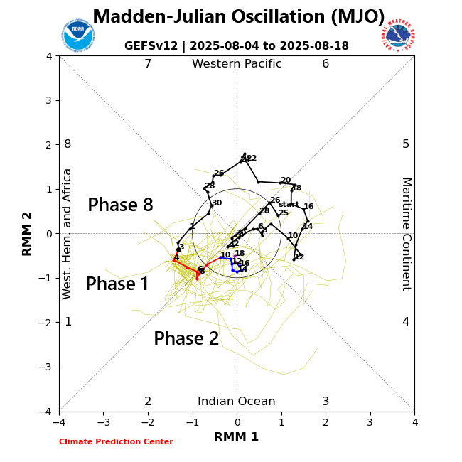
The MJO has moved into a favorable position for tropical activity to form in the Atlantic Basin and it appears the next few weeks may feature multiple systems to closely monitor. Map courtesy NOAA
Another tropical wave has just pushed off the west coast of Africa and while it has a good chance of intensifying in coming days and will be monitored…it could end up recurving into the central Atlantic without ever reaching land. A third area of interest is an area of low pressure just off the US Southeast coast. This system could intensify into tropical storm status during the next couple of days as it is sitting over some very warm waters of the southwestern Atlantic. Whether or not this system reaches tropical storm status, it could produce lots of rainfall in the Carolinas later this week and potentially, in the Mid-Atlantic region by later this weekend. Meanwhile, perhaps the most impressive looking wave of all at this time is a strong tropical system now pushing westward across the western part of Africa...this will be something to monitor during the next couple of weeks and it could become a big headache later in the month.

Whether or not the system currently right near the US Southeast coastline actually intensifies into named tropical storm status, it can still produce significant rainfall amounts in coming days across the Carolinas and that rain can potentially reach the Mid-Atlantic region. Map courtesy ECMWF, Weather Bell Analytics
One of the factors leading to a sudden spurt of tropical activity in the Atlantic Basin has to do with the positioning of the Madden-Julian Oscillation or MJO. The MJO is an oceanic-atmospheric phenomenon that is tracked closely by meteorologists as it can have important effects on weather patterns across the globe and creates favorable conditions for tropical cyclone development. Unlike El Nino or La Nina which are stationary features in the equatorial Pacific Ocean, the MJO is an eastward moving disturbance of clouds, rainfall, winds and pressures that traverse the planet in the tropics and returns to its initial starting point in 30 to 60 days, on average. The MJO was first discovered in the early 1970s by Dr. Roland Madden and Dr. Paul Julian when they were studying tropical wind and pressure patterns.
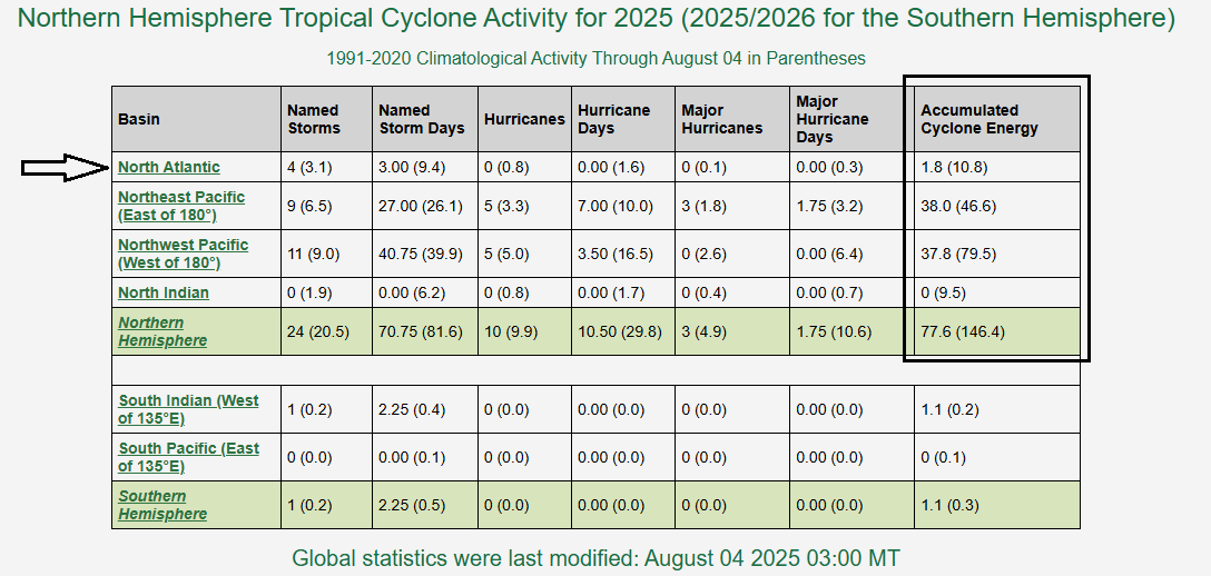
Accumulated Cyclone Energy (ACE, right column) remains at below-normal levels in the Atlantic Basin, but that could change significantly during the next few weeks with a marked uptick expected in overall tropical activity. Table courtesy NOAA, Colorado State University
The MJO consists of two parts or phases with one being the enhanced rainfall (convective) phase and the other being the suppressed rainfall phase. The location of the convective phases is often grouped into geographically based stages that are numbered 1-8 by scientists. The month of July generally featured unfavorable conditions for tropical activity to develop in the Atlantic Basin with respect to the positioning of the MJO. However, it has now progressed to a more favorable location for Atlantic Basin tropical activity and there will likely be several systems to deal with during the next few weeks as it progresses through “phases” 8, 1, 2 and 3. This expected active stretch of activity in the Atlantic Basin can certainly include one or more threats for the eastern states…stay tuned.
Meteorologist Paul Dorian
Arcfield
arcfieldweather.com
Video discussion: