
*Climatological peak of the tropical season in the Atlantic Basin and it is unusually quiet...global activity below-normal as well...watch for “home-grown” systems down the stretch*
Paul Dorian
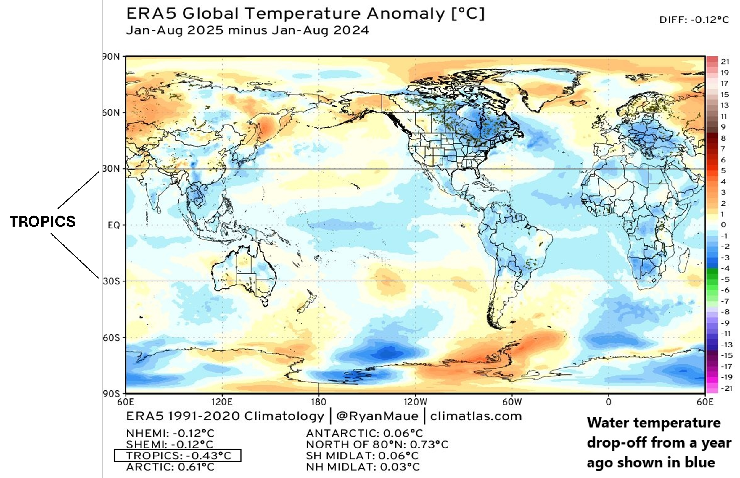
Water temperatures have dropped off dramatically across tropical regions during the past year or so and this is likely a contributing factor to the quieter-than-normal season so far in the Atlantic, Pacific and Indian Oceans. Map courtesy NOAA, Meteorologist Dr. Ryan Maue (X)
Overview
The Atlantic Basin tropical season officially extends from June 1st to November 30th, and the climatological peak is right around the 10th of September. This year is quite unusual in that the climatological peak comes with no tropical activity whatsoever in the Atlantic Basin and the overall season is now below normal for this time of year. In fact, global activity across the entire northern hemisphere is below-normal and that breaks down to each of the oceans being quieter-than-normal (Atlantic, Pacific, Indian). One of the possible explanations for the relatively quiet tropical season across the globe is the dramatic cool down in sea surface temperatures from a year ago. Looking ahead, there is another half of the season to go for the Atlantic Basin - at least in terms of climatology - and signs point to a pickup in activity potentially beginning as soon as this weekend.
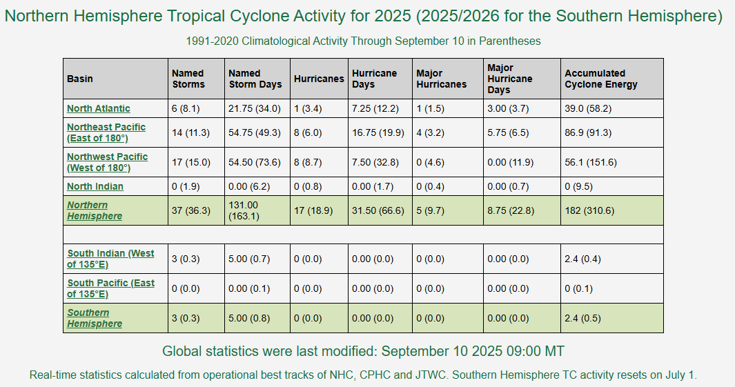
Accumulated Cyclone Energy or ACE is currently running at below-normal levels in all three Northern Hemisphere oceans (i.e., Atlantic, Pacific, Indian). Table courtesy Colorado State University, NOAA
Details
One of the best metrics in the assessment of tropical activity is known as the “Accumulated Cyclone Energy (ACE)” as it factors in not only the magnitude of a tropical cyclone, but also its longevity. For this reason, a weak and short-lived tropical cyclone will add little to the overall ACE whereas a category 4 or 5 hurricane that lasts for a couple of weeks would increase its value significantly. Currently, ACE is running at about 59% of normal across the Northern Hemisphere and this includes all three oceans of the Atlantic, Pacific and Indian. The Atlantic Basin had climbed to above-normal levels in ACE earlier this season after the very powerful and long-lasting life of Hurricane Erin, but there has been a general lull in activity in subsequent recent weeks. In the Pacific Ocean, ACE is usually split into eastern and western sections given its immense size, and both areas are running at below-normal levels for this time of year. In fact, this is nothing new for the western Pacific Ocean – the most important area for global tropical activity – as it has been at or below-normal for overall activity on all but two occasions during the past couple of decades. In the Indian Ocean, there has been no tropical activity at all so far this year with dry air dominating the scene over the water with one possible explanation being the far displaced monsoon this summer which is well to the northeast of its normal position (credit Meteorologist Joe Bastardi, Weather Bell Analytics).
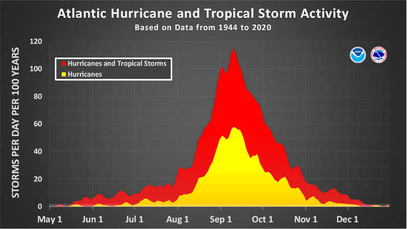
The climatological peak of the Atlantic Basin tropical season comes right around the 10th of September due to a combination of high sea surface temperatures, moist air, and typical low wind shear. Plot courtesy NOAA
Despite it being right at the climatological peak of the Atlantic Basin here on September 10th, it is unusually quiet and hasn’t been so on this particular date since 2016 and on only four occasions during this century. There has been some speculation as to the possible cause of the overall quiet year so far in the Atlantic Basin and all tropical areas around the world from an abundance of dry air intrusions (e.g., from the Sahara Desert region of North Africa) to higher-than-normal wind shear. Another factor that may be the most important of all is the change in sea surface temperatures across the world’s tropical waters where a significant amount of solar energy is absorbed. There has been a dramatic drop-off in sea surface temperatures from a year ago and this is a limiting factor in the development or intensification of tropical cyclones.
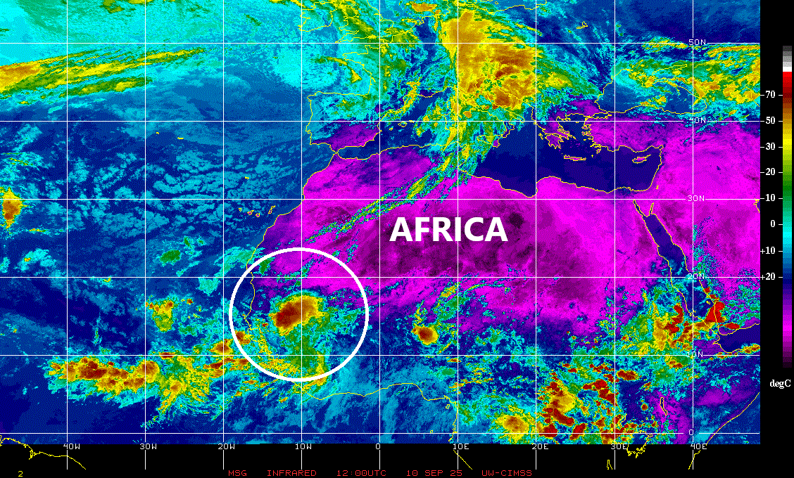
An impressive tropical wave (circled) is about to push off the west coast of Africa and could eventually intensify into a named tropical storm…would be named “Gabrielle”. Map courtesy University of Wisconsin/CIMSS, NOAA
Looking ahead, there is another half of the tropical season to go, and certainly overall activity can change in a hurry. Indeed, the second half of last year’s tropical season in the Atlantic Basin was very active with a dramatic increase beginning in late September with several strong storms including Hurricane Milton which reached category 5 levels during early October. In early November, Hurricane Rafael reached category 3 status and made landfall in western Cuba before entering the Gulf of Mexico as the strongest November on record in that part of the Atlantic Basin (tying Hurricane Kate of 1985).

This forecast map of “integrated vapor transport” indicates there can be a circulation center (circled area) just off of Africa’s west coast by the weekend…this could become the next named tropical storm of the Atlantic Basin season. Map courtesy ECMWF, Meteorologist Dr. Ryan Maue (X)
As far as the near-term is concerned in the Atlantic Basin, latest satellite images show quite an impressive wave over the western part of Africa. This system is likely to push westward to a position over the far eastern Atlantic Ocean by the upcoming weekend and it could intensify thereafter into a named tropical storm (would be “Gabrielle”). One final note, there tends to be more in what I like to call “home-grown” tropical systems during the latter half of the tropical season. As a result, we’ll have to watch for potential development in areas such as the Caribbean Sea, Gulf of Mexico, and southwestern Atlantic Ocean in coming weeks rather than to the western part of Africa.
Meteorologist Paul Dorian
Arcfield
arcfieldweather.com