
****Multiple Arctic blasts featuring some incredible cold...major weekend winter storm likely to impact a large part of the nation...big-time impact on the table for the Mid-Atlantic region****
Paul Dorian
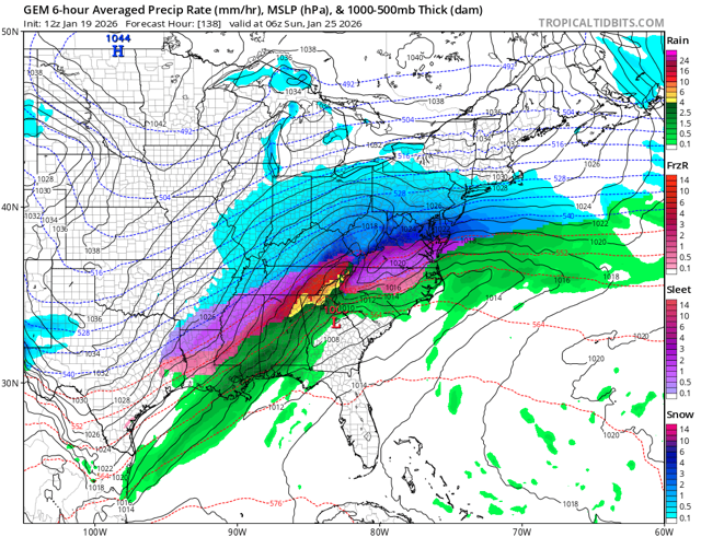
A major winter storm is likely to impact a large part of the nation this weekend with significant icing in some areas (shown in purple) and substantial snow is other areas (shown in blue). Map courtesy Canadian Met Centre, tropicaltidbits.com
Overview
The next couple of weeks will feature multiple Arctic outbreaks...some incredible cold...and the likelihood of a major weekend winter storm that will impact a large part of the nation in a variety of ways. The core of the coldest air associated with the current Arctic outbreak reaches the Mid-Atlantic region for the period tonight, tomorrow, and tomorrow night and some suburban locations can see single digits lows by early Wednesday. There will be a temporary modification in temperatures on Thursday in the Mid-Atlantic region and then another Arctic air mass will push in for the upcoming weekend. This late week/weekend blast will feature some incredible cold with temperatures as low as 30 degrees below zero in portions of the Upper Midwest/Northern Plains, and bitter cold is a possibility in the Mid-Atlantic region during the upcoming weekend.
At the same time the next Arctic invasion swallows up the northern states, moisture will be gathering across the south-central states. As this moisture pushes to the north and east, it will encounter this very cold air mass, and the result could be icing across many southern states – potentially a crippling event - and significant accumulating snow to the north. There will likely be a very strong Arctic high pressure system over the Northeast US this weekend anchoring the bitter cold air mass in place and the extent to which the moisture field can penetrate north and east into the Mid-Atlantic/Northeast US will have to be better determined in coming days. Suffice to say, the potential is there for a big-time impact this weekend in the Mid-Atlantic region given the Arctic cold to the north and copious amounts of moisture to our south.
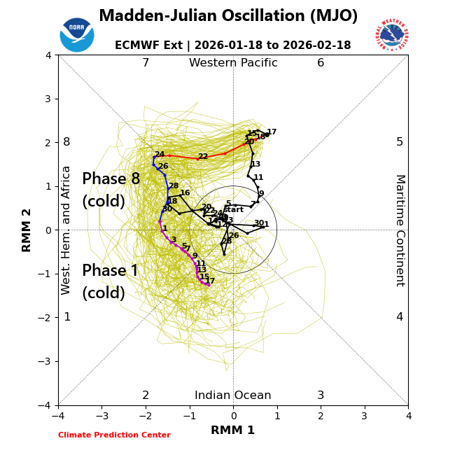
Numerous teleconnection indices support the idea of an extended cold spell for the central and eastern US including the North Atlantic Oscillation, Arctic Oscillation (not shown), and the Madden-Julian Oscillation or MJO which moves into cold “phases” for the central and eastern US this time of year. Map courtesy NOAA, ECMWF
Details
On the heels of the weekend snow in parts of the Mid-Atlantic region, very cold Arctic air is poised to push into the area from the north and west. In fact, the coldest core of this Arctic air mass relative-to-normal will move into the DC-to-Philly-to-NYC corridor for the period from tonight through tomorrow night. Temperatures later tonight should bottom out in the middle teens across the DC metro region and not far from ten degrees in the Philly and NYC metro regions where there is some snow cover. On Tuesday, stiff NW winds will combine with unusually low temperatures to produce wind chills below zero at times throughout the Mid-Atlantic region. The lowest temperatures are likely to come tomorrow night with single digit overnight lows likely in many suburban locations along the DC-to-Philly-to-NYC corridor.
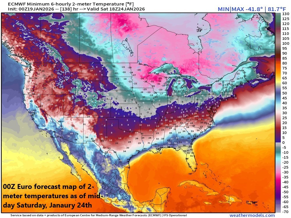
The late week/weekend Arctic blast may feature some incredible cold with actual temperatures as low as 30 degrees below zero in portions of the Northern Plains/Upper Midwest. Map courtesy ECMWF, weathermodels.com (Ryan Maue, X)
By Thursday, the harsh conditions will give way to moderation in temperatures, but the reprieve will be a short one. Another Arctic air mass will blast into the Northern Plains/Upper Midwest later in the week and this will feature some incredible cold with temperatures dropping to as much as 30 degrees below zero in some spots of the Northern Plains and Upper Midwest. This next Arctic outbreak will spread south and east by the weekend and the Mid-Atlantic region is likely to be in the deep freeze for the upcoming weekend with far below-normal temperatures at the same time moisture heads in this direction.
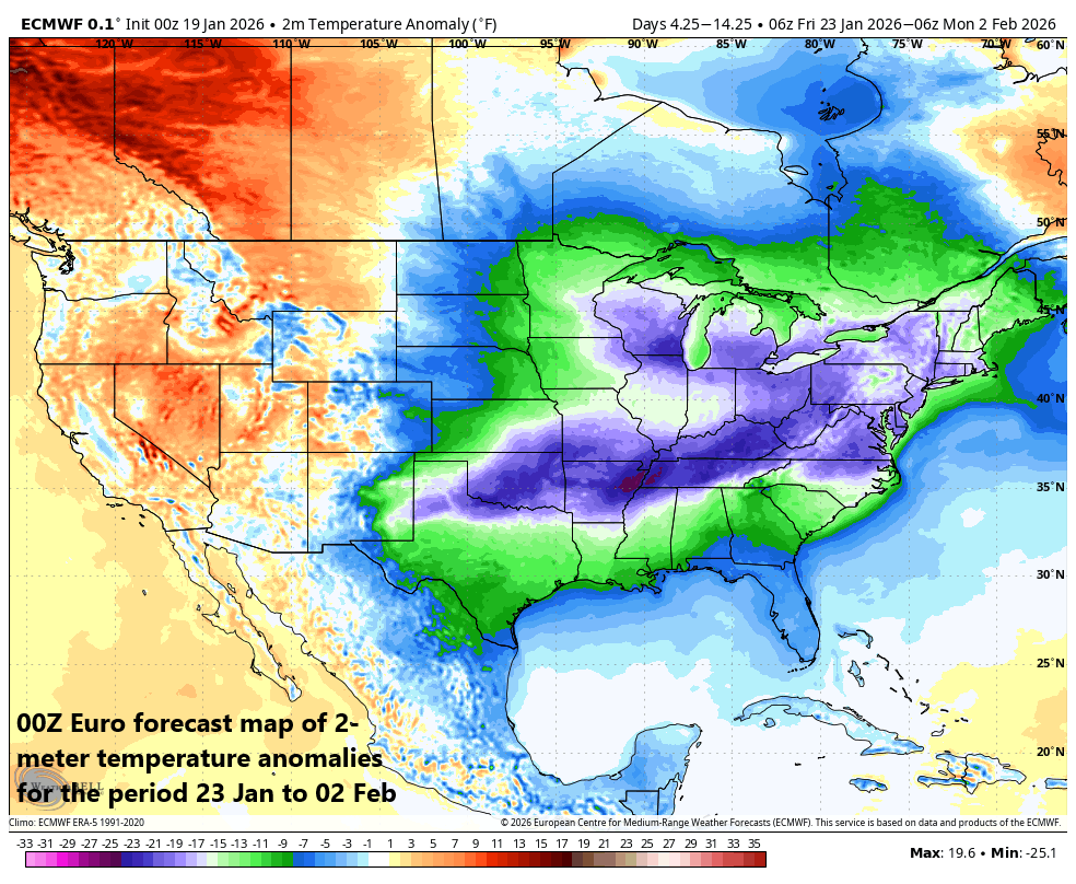
The time period of 23 January to 02 February looks cold indeed across the eastern 2/3rds of the nation. This notion of an extended cold pattern is supported by numerous teleconnection indices including the Madden Julian Oscillation (MJO, shown above) which pushes into cold “phases” for the central and eastern US during late January and early February. Map courtesy ECMWF, Weather Bell
By Friday night and Saturday, moisture will start gathering across the south-central states. As this moisture shield then heads to the north and east, it will encounter a very cold air mass having its origins in the Arctic region. As such, frozen precipitation will break out with significant - and potentially crippling - icing possible this weekend across many southern states. As the moisture field pushes farther to the north and east, snow will break out, and significant accumulations are on the table in the region from the Middle Mississippi Valley to the Tennessee Valley to the Mid-Atlantic region. Many details have to be ironed out on the weekend storm – still several days away - but the potential is there for a big-time impact across a large portion of the country including the Mid-Atlantic region, and the incredible cold will certainly become a newsworthy event as well...buckle up, the next couple of weeks will feature the worst that winter has to offer.
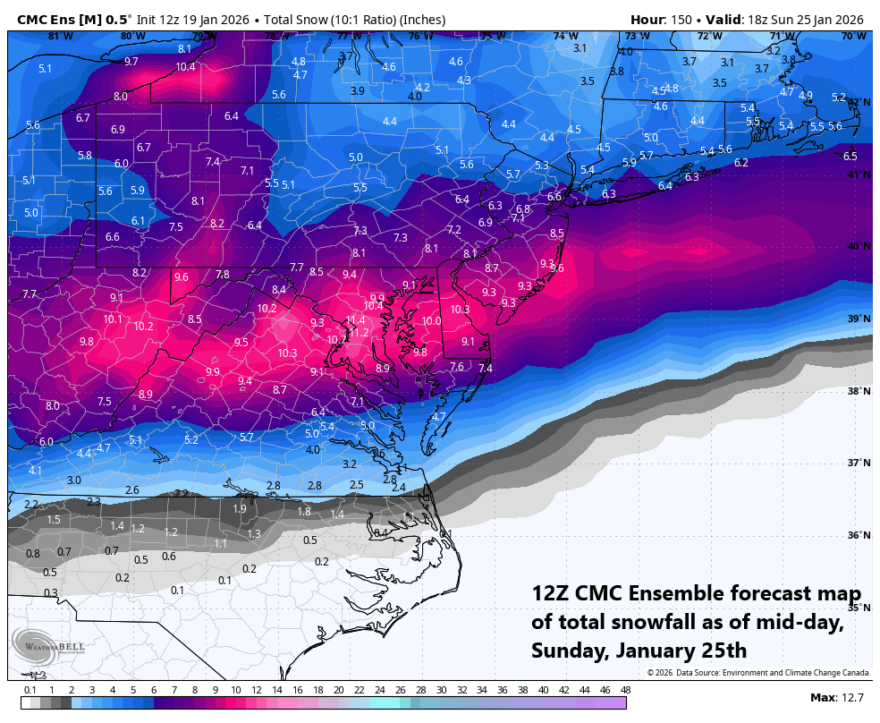
The total snowfall forecast map by the 12Z CMC Ensembles raises a red flag for a big-time impact this weekend in the Mid-Atlantic region. Map courtesy Canadian Met Centre, Weather Bell
Meteorologist Paul Dorian
Arcfield
arcfieldweather.com
Follow us on Facebook, Twitter, YouTube
Video discussion: