
*****The next Arctic blast arrives in the US by week's end setting the stage for widespread impacts by major storm system...crippling icing event in some areas...significant snowfall in others*****
Paul Dorian
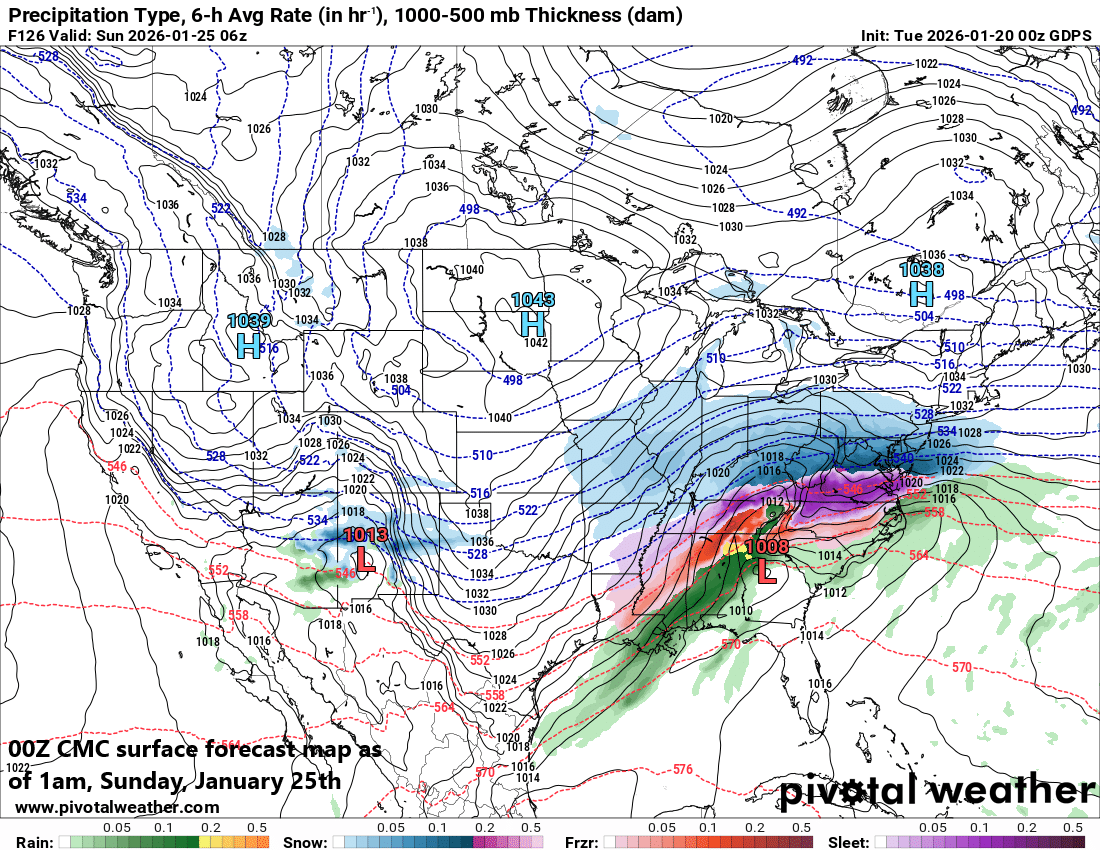
A major winter storm is likely to impact a large part of the nation this weekend with significant icing in some areas (shown in purple, pink) and substantial snowfall in other areas (shown in blue). Map courtesy Canadian Met Centre, Pivotal Weather
Overview
The next couple of weeks will feature some of the worst weather winter has to offer with bitter cold conditions and a major storm system that can bring a crippling ice event to some areas this weekend and significant snowfall to others. The coldest core of the current Arctic air outbreak has reached the Mid-Atlantic region, and temperatures are likely to bottom out later tonight in the single digits across many suburban locations along the I-95 corridor. There will be a temporary modification in temperatures on Thursday in the Mid-Atlantic region and then another Arctic air mass will push in for the upcoming weekend. This late week/weekend blast will feature some incredible cold with temperatures as low as 30 degrees below zero in portions of the Upper Midwest/Northern Plains, and more bitter cold is a likelihood in the Mid-Atlantic region during the upcoming weekend. By the end of the week, moisture will be gathering across the south-central states. As this moisture pushes to the north and east, it will encounter this very cold air mass, and the result will be icing across many southern states – potentially a crippling event - and significant accumulating snow farther to the north and this potentially includes the Mid-Atlantic region.
The potential exists for a crippling icing event this weekend in the region from Texas-to-the-Carolinas. The stage may be set by an influx of Arctic air that’ll drive far to the south and east as copious amounts of moisture pushes north and east from the south-central states. Map courtesy Canadian Met Centre, Pivotal Weather
Details
With the coldest core of the current Arctic outbreak now in the Mid-Atlantic region, temperatures today will struggle to climb into the 20’s and some suburban locations later tonight will drop to single digits...levels seldom seen in these parts. By Thursday, the harsh conditions will give way to moderation in temperatures, but the reprieve will be a short one. Another Arctic air mass will blast into the Northern Plains/Upper Midwest later in the week and this outbreak will feature some incredible cold with temperatures dropping to as much as 30 degrees below zero in some spots across the Northern Plains. This next Arctic air mass will then spread south to Texas and east to the east coast during the upcoming weekend setting the stage for a major weekend winter storm that will affect a large part of the nation.
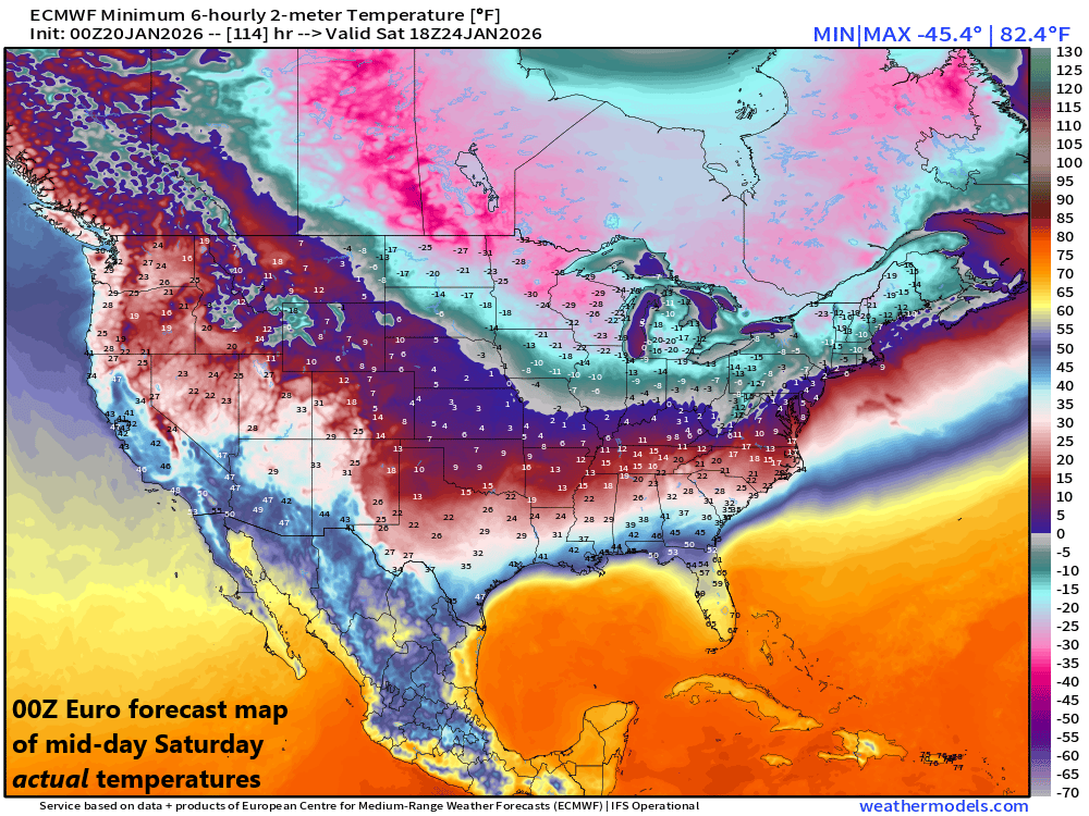
The late week/weekend Arctic blast will feature some incredible cold with actual temperatures as low as 30 degrees below zero in portions of the Northern Plains/Upper Midwest. Map courtesy ECMWF, weathermodels.com (Ryan Maue, X)
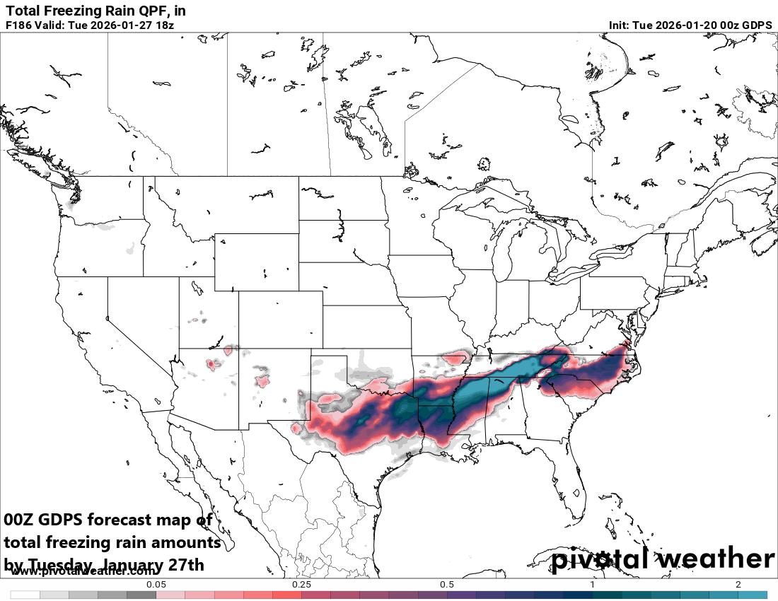
By late Friday, moisture will start gathering across the south-central states. As this moisture shield then heads to the north and east, it will encounter a very cold air mass with its origins in the Arctic. As such, frozen precipitation will break out with significant - and potentially crippling - icing possible this weekend across many southern states from Texas-to-the-Carolinas. As the moisture pushes farther to the north and east, snow will break out, and significant accumulations are on the table in the region from the Middle Mississippi Valley to the Tennessee Valley to the Mid-Atlantic region (including the big cities from DC-to-Philly-to-NYC).
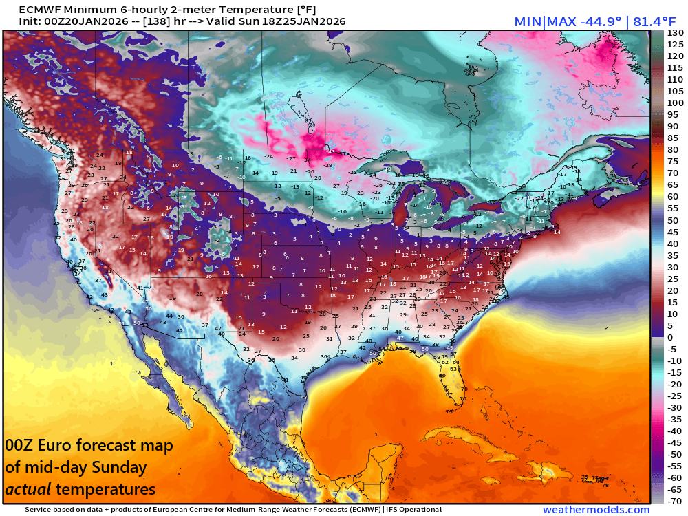
Bitter cold conditions will stick around on Sunday across much of the eastern 2/3rds of the nation meaning this could be a very cold storm system for the Mid-Atlantic region (and high snow ratios). Map courtesy ECMWF, weathermodels.com (Ryan Maue, X)
One of the key factors for the potentially significant snowfall in the Mid-Atlantic region is that it will likely come with very cold conditions leading to high snow ratios. Roughly speaking, there is typically about 10 inches of snow for every one inch of rain (i.e., a 10-to-1 ratio), but when the air is very cold as it should be this weekend, the snow ratios can be considerably higher meaning you can get more snow accumulations with less liquid equivalent precipitation amounts (and the snow would be of the “light and fluffy” variety). Stay tuned…the weekend storm is still several days away, but the potential is high for major impacts across a large part of the nation including the DC-to-Philly-to-NYC corridor...the next couple of weeks will feature some of the worst weather that winter has to offer.
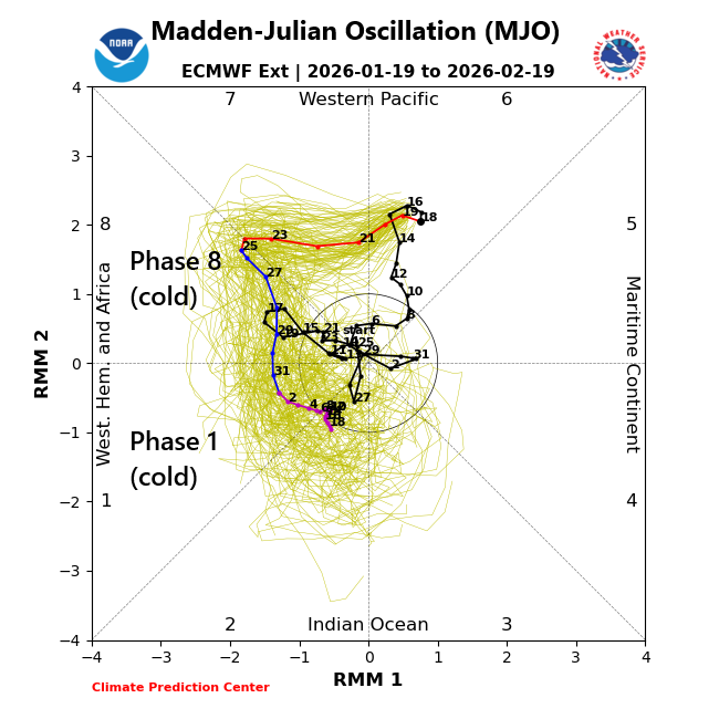
Numerous teleconnection indices support the idea of an extended cold spell for the central and eastern US including the North Atlantic Oscillation, Arctic Oscillation (not shown), and the Madden-Julian Oscillation or MJO which moves into cold “phases” for the central and eastern US this time of year. An MJO in phase 8 this time of year also is generally quite favorable for east coast storms. Map courtesy NOAA, ECMWF
Meteorologist Paul Dorian
Arcfield
arcfieldweather.com
Follow us on Facebook, Twitter, YouTube
Video discussion: