
*****Major winter storm arrives tonight in the Mid-Atlantic region with disruptions into Monday…significant snow and significant icing in the I-95 corridor…bitter cold to follow*****
Paul Dorian
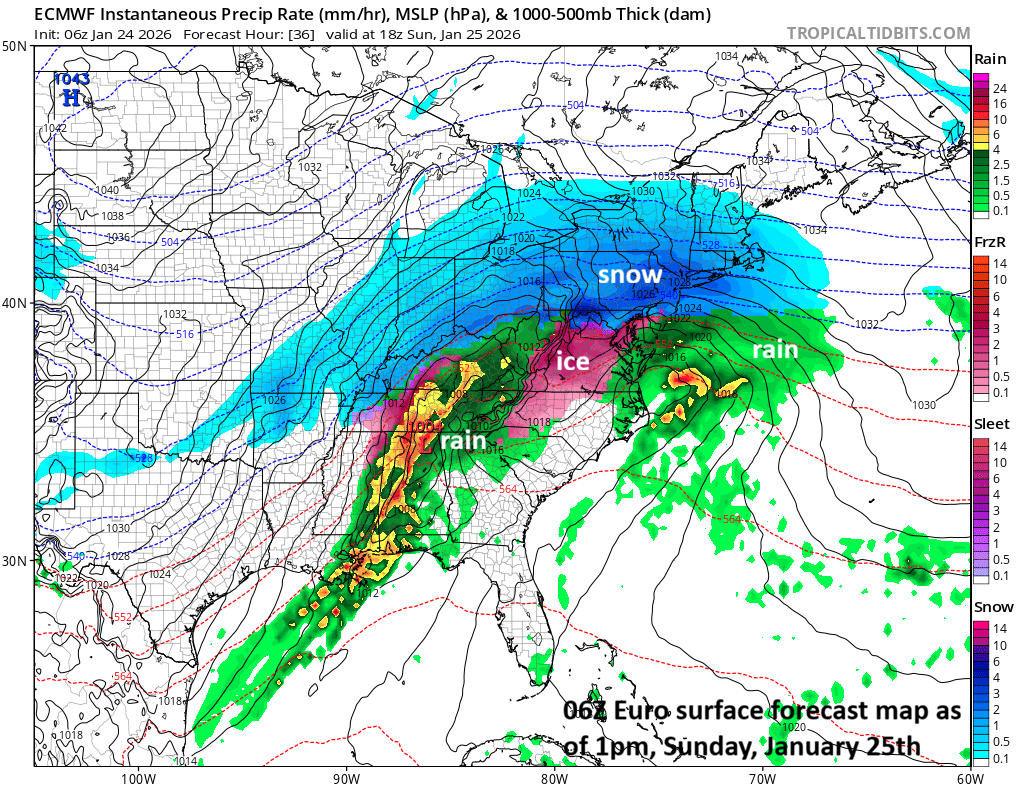
Snow should be falling heavily on Sunday morning in much of the DC-to-Philly-to-NYC corridor with very cold conditions…some wild weather indeed for several hours. There can be sleet and freezing rain across central and western Virginia by mid-day as a thin layer of slightly above freezing air advances slowly to the north with its farthest northern reach later Sunday probably right around NYC. An initial low pressure system will head to West Virginia and then a secondary low will develop just off the Mid-Atlantic coastline and it’ll become the main player by later Sunday. Map courtesy ECMWF, tropicaltidbits.com
Overview
Temperatures plunged in the overnight hours as the latest in a series of Arctic air outbreaks spread eastward to the Mid-Atlantic region setting the stage for a major winter storm with big-time disruptions. This storm will bring significant snowfall to the DC-to-Philly-to-NYC corridor and a changeover to sleet and freezing rain will exacerbate problems with an ice buildup in some areas, unfortunately, raising the chance of power outages. The precipitation lasts into early Monday, suggesting there will be travel impacts as the new work week begins. Bitter cold air will follow the storm with low temperatures likely flirting with the zero-degree mark in many spots along the I-95 corridor.
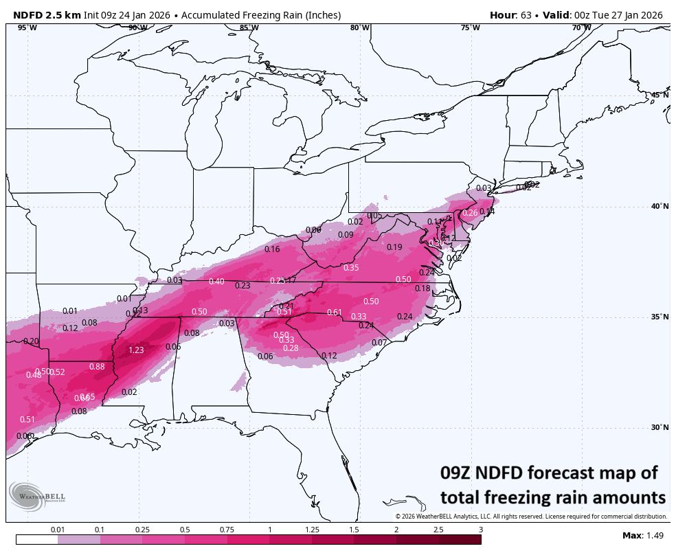
A thin layer of slightly above freezing air is likely to cause the snow to mix with or changeover to sleet and/or freezing rain for awhile in the much of the DC-to-Philly-to-NYC corridor. The freezing rain can turn out to be rather significant in some spots as this forecast map suggests. Map courtesy NOAA, Weather Bell
Details
An Arctic front passed through the Mid-Atlantic region last night, and temperatures plunged in the overnight hours to single digits in many locations. Clouds will thicken today as a large moisture field pushes in this direction from the Mississippi Valley…snow will break out in the DC area between 8pm and 11pm, between 11pm and 2am in Philly, and between 2am and 5am in the NYC metro region. The snow will continue heavily at times for a several hour period and this will be accompanied by some very cold conditions…some of the lowest temperatures you’ll ever see in the I-95 corridor with heavy snow.
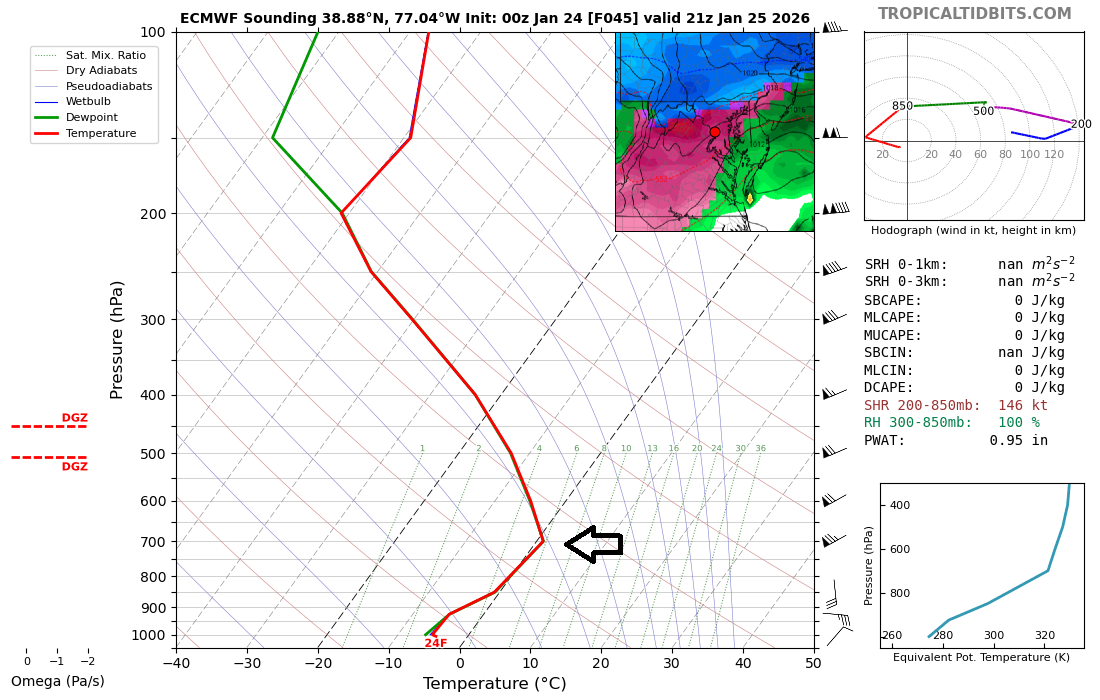
While surface temperatures will remain below-freezing throughout this event, there can be a thin layer of air nosing into the upper atmosphere with slightly above-freezing temperatures and this can cause sleet to fall instead of snow. (If the slightly above freezing layer of air becomes thicker, freezing rain would be the result). This vertical profile data is for later Sunday afternoon right near Washington, D.C. and the arrow indicates the location aloft of that narrow layer of air with slightly above-freezing temperatures. Map courtesy ECMWF, tropicaltidbits.com
Later tomorrow, the snow will change over to sleet and freezing rain in much of the I-95 corridor even though surface temperatures will remain well below freezing. A thin layer of slightly above-freezing air is likely to nose into the upper part of the atmosphere along the I-95 corridor as the initial (primary) surface low heads towards West Virginia. This initial low will then weaken and transfer its energy to a secondary low pressure that’ll form just off the Mid-Atlantic coastline and become the main player. Ultimately, any sleet and freezing rain that does form can change back to snow as the coastal low takes full control.
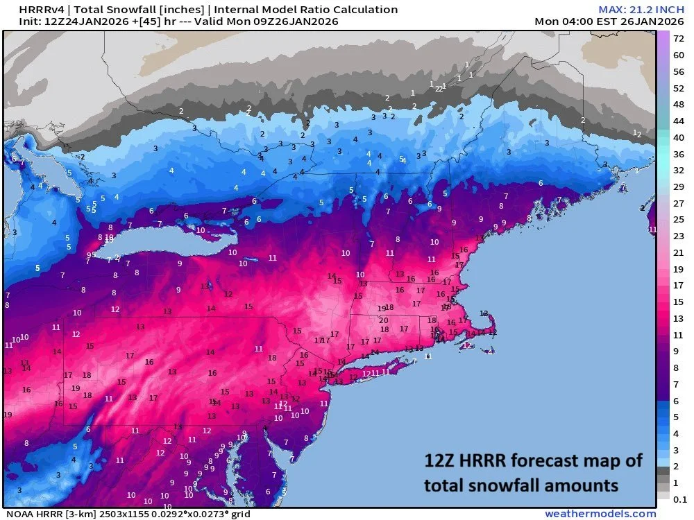
This is the forecast map of total snowfall amounts by the 12Z HRRR model with significant amounts in the Mid-Atlantic region. Map courtesy NOAA, weathermodels.com
Before the changeover to sleet and freezing rain, snow accumulations will be significant in the I-95 corridor with 6-12 inches in the DC metro region, and 8-14 inches in the Philly and NYC metro areas with the higher amounts in those ranges in the far northern and western suburbs and the lower amounts to the south and east. Farther to the north, the average snowfall amounts may end up in the 14-18 inch range in that zone from around north-central MD to upstate PA to interior NW NJ. The sleet will fall long enough to produce a deep layer of ice (pellets) on top of the snow which will pack it down some. The freezing rain is the biggest concern as it can quickly lead to a buildup of ice -from a tenth to a quarter of an inch in some areas - and unfortunately, this raises the possibility of power outages.
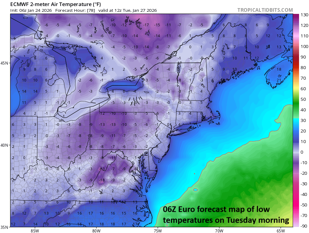
Temperatures could flirt with the zero-degree mark next week for overnight lows…even in the big cities along I-95. Map courtesy ECMWF, tropicaltidbits.com
Bitter cold air will follow the storm next week with low temperatures likely flirting with the zero-degree mark on more than one occasion in the DC-to-Philly-to-NYC corridor. The last time Philly and Washington, D.C. recorded temperatures below zero was in January of 1994 (remembered as the winter of numerous ice storms in Philly)…Central Park in NYC last recorded below zero temperatures in February 2016.
Meteorologist Paul Dorian
Arcfield
arcfieldweather.com