*****Major winter storm to impact the DC-to-Philly-to-NYC corridor from later Saturday night into Monday…significant snow accumulations and serious icing…bitter cold to follow*****
Paul Dorian

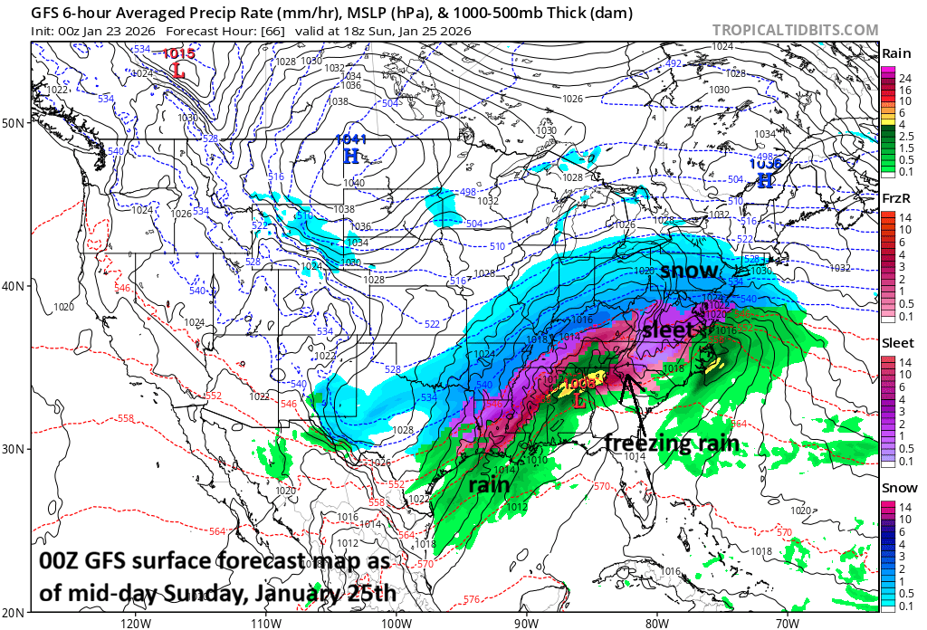
Snow should be falling heavily on Sunday morning/mid-day in the DC-to-Philly-to-NYC corridor with very cold conditions…some wild weather indeed for several hours. There can be sleet across central and southern Virginia at mid-day and freezing rain in Kentucky as a thin layer of slightly above freezing air advances slowly to the north with its farthest northern reach probably right around NYC. An initial low pressure system will head to Kentucky/West Virginia and then a secondary low will develop just off the Mid-Atlantic coastline and it’ll become the main player by later Sunday. Map courtesy NOAA, tropicaltidbits.com
Overview
A major winter storm is headed to the Mid-Atlantic region, and it will bring significant snowfall to the DC-to-Philly-to-NYC corridor and there will be some icing as well. The stage will be set for the winter storm with the arrival of Arctic air into the Mid-Atlantic region in the overnight hours and it’ll remain below freezing throughout the weekend weather event. The icing would be predominately in the form of sleet; however, freezing rain can get involved in some areas which always raises a red flag for the potential of power outages due to an ice buildup. Bitter cold air will follow the storm with low temperatures likely flirting with the zero-degree mark next week even in the big cities.
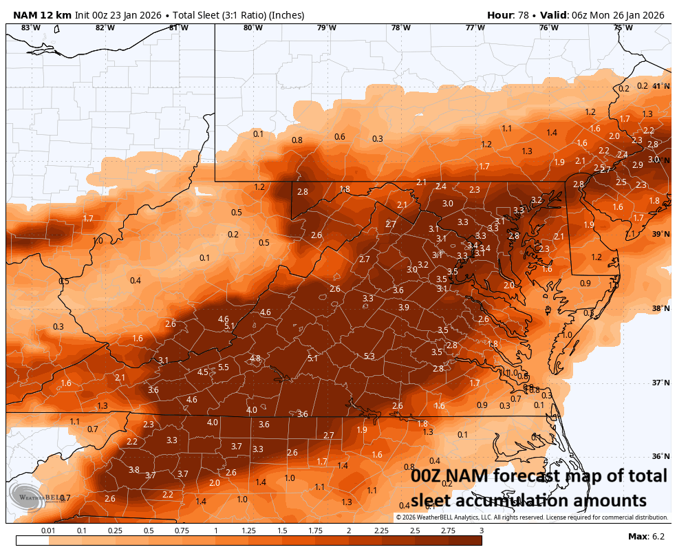
A thin layer of slightly above freezing air is likely to cause the snow to mix with or changeover to sleet and/or freezing rain for awhile in the southern Mid-Atlantic region to include much of the DC-to-Philly-to-NYC corridor. The sleet can turn out to be rather significant as this forecast map suggests. Map courtesy NOAA, Weather Bell
Details
It turned noticeably milder on Thursday in the Mid-Atlantic region, but that warmup was just a temporary blip and by later tonight the next in a series of unrelenting Arctic air masses will arrive in the area. This latest Arctic blast will set the stage for big-time problems across much of the eastern 2/3rds of the nation this weekend - and it is the real deal. Temperatures can drop to as low as 30 below across the Northern Plains and wind chills can reach 50 below in many areas. Copious amounts of moisture begin to gather today across the south-central states and then this shield will make a move to the north and east into this bitter cold air mass.
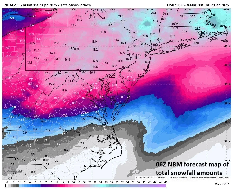
This is a forecast map of total snowfall amounts for the upcoming event by a compilation of computer forecast models with significant totals throughout the Mid-Atlantic region. Any sleet and freezing rain that falls would put a limit in those particular areas on final snowfall amounts. Map courtesy NOAA, Weather Bell
The vast moisture field will reach the Mid-Atlantic region later Saturday night with snow likely to break out in DC and Philly close to midnight and just after midnight in the NYC metro area. The snow will be heavy at times late Saturday night and Sunday morning with very cold conditions to accompany…some wild weather conditions indeed. By later Sunday, the snow is likely to mix with or change to sleet in many areas along the I-95 corridor and freezing rain can mix into the picture as well. The snow accumulations should become significant on the order of 8-14 inches with the higher amounts in that range to the north and west and the lower amounts to the south and east and a deep layer of sleet may fall on top of the snow. Isolated higher amounts of snow are possible in the far northern and western suburbs of the big cities where icing is minimal or never develops at all. As far as potential for an ice build-up is concerned…as much as a tenth to a quarter inch can accumulate in portions of the I-95 corridor during the freezing rain stage of the winter storm…power outages are on the table as a result.
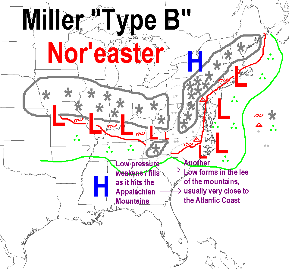
There are a few different types of storm tracks that tend to dominate during a winter season in the central and eastern US. One storm track which dominated during the first half of the winter was along a line from southwestern Canada to the NE US. These “clipper” low pressure system pushed along in the polar jet which dominated the early winter. A “Miller A” storm track is one that takes low pressure right up over or near the eastern seaboard. A third storm track known as a “Miller B” features an initial or primary low that heads to the Appalachians, weakens, and transfers its energy to a newly forming secondary low just off the east coast. This “Miller B” scenario is what we will be dealing with this weekend in the northeastern part of the country.
The mixing with or changeover to sleet and/or freezing rain is likely despite the surface temperatures likely staying below freezing throughout the event. A thin layer of slightly above-freezing air is likely to nose into the upper part of the atmosphere along the I-95 corridor later Sunday as the initial (primary) surface low heads towards Kentucky/West Virginia. This initial low pressure system will then weaken and transfer its energy to a secondary low pressure that’ll form just off the Mid-Atlantic coastline (i.e., a “Miller B” type of storm track). As the initial low reaches its most northward extent over the Appalachians, so will the narrow layer of air aloft with slightly above freezing temperatures…probably no farther north than near New York City. Then as the secondary low becomes the main player just off the east coast, colder air aloft will tend to push back to the south and east. In other words, many areas in the I-95 corridor are likely to see their sleet and/or freezing rain change back to snow before the precipitation winds down on Monday.
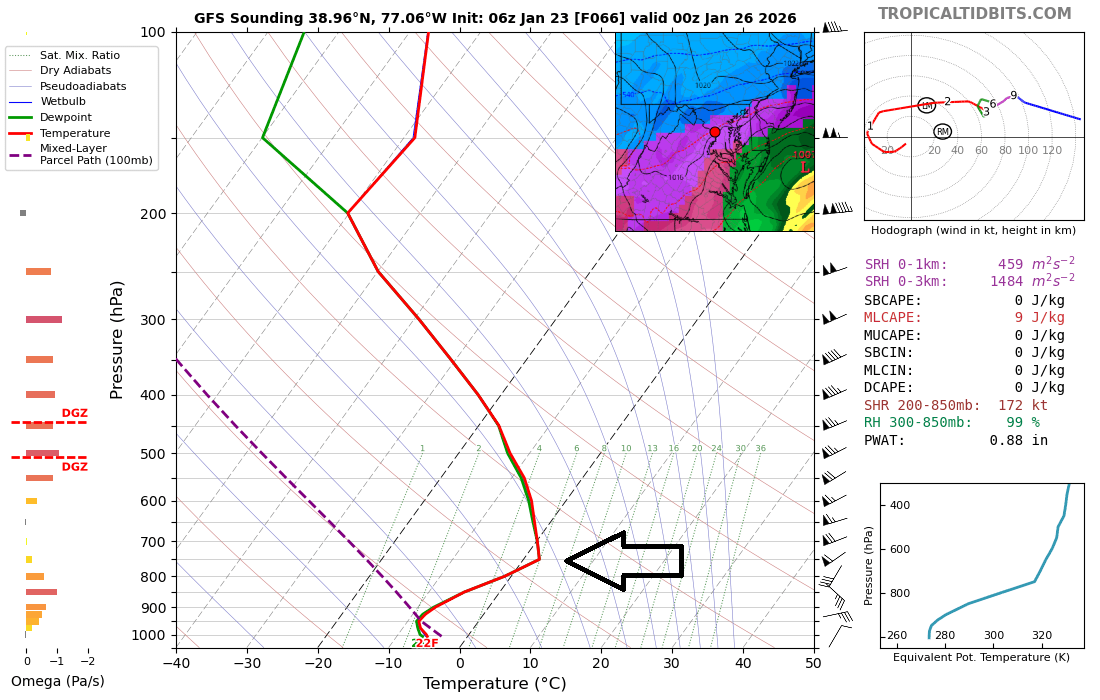
While surface temperatures will remain below-freezing throughout this event, there can be a thin layer of air nosing into the upper atmosphere with slightly above-freezing temperatures and this can cause sleet to fall instead of snow. (If the slightly above freezing layer of air becomes thicker, freezing rain can be the result). This vertical profile data is for late Sunday right near Washington, D.C. and the arrow indicates the location aloft of that narrow layer of air with slightly above-freezing temperatures. Map courtesy NOAA, tropicaltidbits.com
Bitter cold air will follow the storm with low temperatures likely flirting with the zero-degree mark in the DC-to-Philly-to-NYC corridor during the first half of next week. The last time Philly and Washington, D.C. recorded temperatures below zero was in January of 1994…Central Park in NYC last recorded below zero temperatures in February 2016. And a quick look ahead, there can be another major storm to deal with along the east coast in about a week after this weekend’s event (i.e., somewhere around Sunday, 2/1)...more on that threat next week and that one could end up producing more accumulating snow in the Deep South.
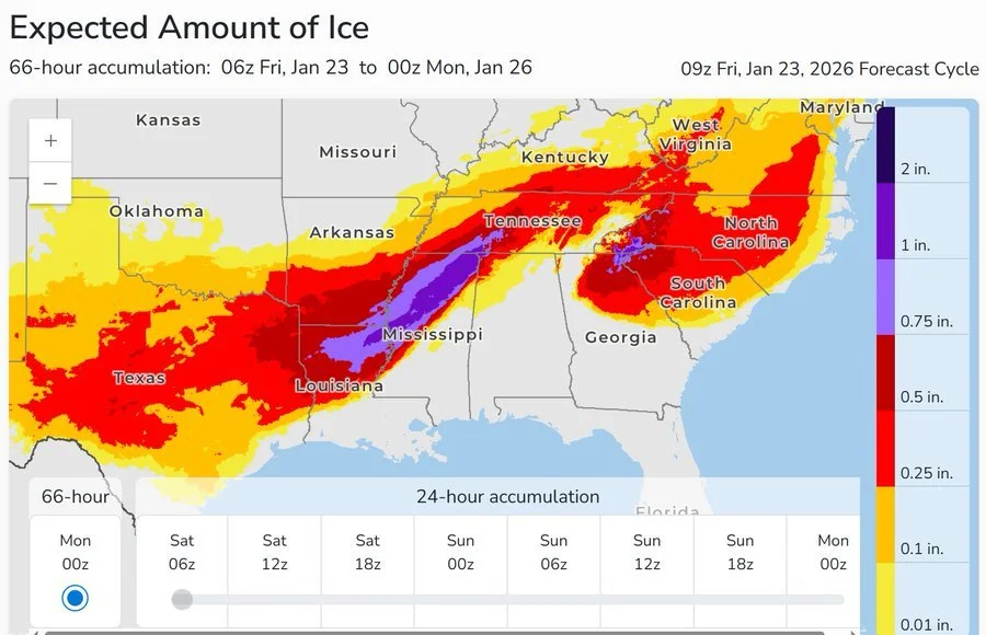
Unfortunately, some areas are likely to receive a significant amount of ice buildup during this weather event which can lead to widespread power outages. This particular forecast map (from an experimental NOAA product) raises a red flag for portions of Louisiana, Mississippi and Tennessee where there could be appreciable ice buildup. Map courtesy NOAA
There is still a bit of time to go before this weekend’s event and there can be some minor adjustments; however, from this vantage point, all signs continue to point to a major winter storm that will have big-time impacts across a large portion of the nation…this would include a crippling ice event in some areas, and a significant snowfall in other areas including the DC-to-Philly-to-NYC corridor where some icing is also quite likely to get involved. Buckle up…the next ten days or so will contain some wild weather including more bitter cold air outbreaks and additional storm threats.
Meteorologist Paul Dorian
Arcfield
arcfieldweather.com