****Memorable stretch of cold in terms of both magnitude and duration...near 0 degrees for overnight lows on multiple occasions…monitoring weekend storm threat****
Paul Dorian

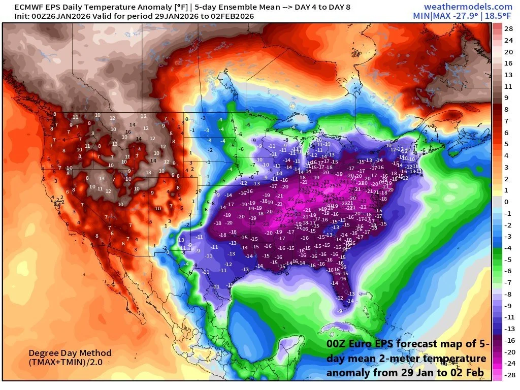
The 5-day period from 29 January to 02 February looks to be especially cold in much of the eastern US and this includes the central and southern portions of Florida. Map courtesy ECMWF, weathermodels.com (Dr. Ryan Maue, X)
Overview
In the wake of the major weekend winter storm, a very cold weather pattern is setting up in the Mid-Atlantic region, and it looks like it’ll be quite a memorable stretch both in terms of magnitude and duration. There may be record low temperatures in coming days as well as record low high temperatures; especially, in the period of the 29th to the 31st. In addition to the cold, there are signals for a powerful storm this weekend over the western Atlantic and it certainly can become a big-time snow producer for portions of the northeastern states.
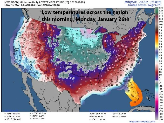
Talk about extreme cold…the average minimum temperature across the nation on Monday morning, January 26th, was 9.3 degrees (F). This average low temperature for the nation as a whole falls in the lowest 5th percentile for the month of January since records began in the early 1950’s. Map courtesy NOAA, Dr. Ryan Maue (X)
Details
Today is likely to be the “warmest” day of the week with afternoon highs generally in the mid to upper 20s, but bitter cold air returns tonight riding into the area on stiff NW winds. Overnight low temperatures will drop into upper single digits in many spots aided by a fresh cover of snow (and ice). A tight pressure gradient between the departing low-pressure system and a strong high pressure to the south will keep winds strong through the night producing wind chills below zero throughout the area.
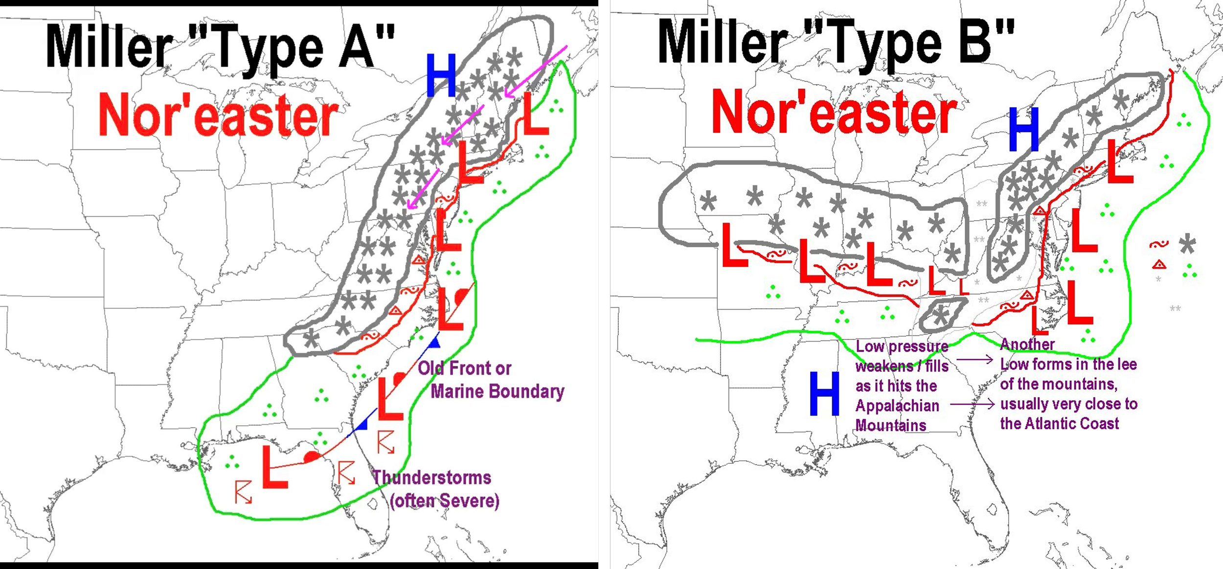
The just ended winter storm featured a “Miller B” scenario with an initial (primary) low over the Appalachians giving way to a secondary coastal low. The potential exists for a “Miller A” type scenario this upcoming weekend with a low moving from the Gulf region to near the eastern seaboard.
A reinforcing shot of Arctic air arrives on Tuesday night as a cold front sweeps through the region and temperatures will take even more of a tumble. Overnight lows during the second half of the week will be at or below zero in many locations and daytime highs generally confined to the teens. The last time Philly Airport (PHL) and Reagan National Airport in Washington, D.C. (DCA) recorded temperatures below zero was in January of 1994, and the last time for Central Park in New York City was in February 2016…on the table during this cold stretch.
Other notes on the cold...record lows and record low high temperatures are on the table; especially, later this week. For example, Philly’s record low temperature on Friday, January 30th is 7 degrees set in 2019, and the record low high temperature for the date is 18 degrees set in 1965...both are in jeopardy. In NYC, the longest stretch of below freezing days is 16...also in jeopardy. Finally, this bitter cold is impacting Florida as well with 30’s likely in many areas on Tuesday morning and even colder conditions are likely later this weekend on the back side of the expected strong coastal storm.
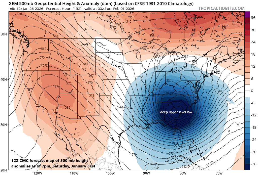
The potential exists for a powerful storm this weekend that rides up along or near the Atlantic seaboard. Questions remain as to the exact track of this weekend storm, but this could be a “classic nor’easter” scenario that ends up producing a lot of snow in portions of the northeastern states. Map courtesy CMC, tropicaltidbits.com
In terms of upcoming storm possibilities…there will likely be a strong storm this weekend somewhere near the eastern seaboard. Signs point to a storm system that develops near the Gulf by the weekend and then pushes up along or near the eastern seaboard. It is too early to say if it comes close enough to the coast for a big impact in the Mid-Atlantic/Northeast US or if it will take an “out-to-sea” type of track. The overall scenario is likely to mimic a “Miller A” type of storm track with one low pressure system riding up along or near the east coast which is a different scenario than the just departed storm system that featured more of a “Miller B” setup. In the past weekend scenario, an initial (primary) low pressure headed to the Appalachians while a secondary low formed off the coast. With the initial low reaching as far north as West Virginia on Sunday, a thin layer of slightly above freezing air was able to “nose” into the I-95 corridor creating a changeover from snow to sleet for a several hour period.
Still several days away, questions remain as to whether this potential weekend storm would be close enough to the coast to produce a big impact in the Mid-Atlantic region and Northeast US or far enough away to minimize its effects in the area...stay tuned...relentless bitter cold and storm possibilities...the worst that winter has to offer.
Meteorologist Paul Dorian
Arcfield
arcfieldweather.com
Follow us on Facebook, Twitter, YouTube
Video discussion: