****Hurricane Isaias on the doorstep of “major” category 3 classification…landfall tonight likely near the far western part of Florida’s Panhandle…impacts to the Ohio Valley, Mid-Atlantic, NE US****
Paul Dorian
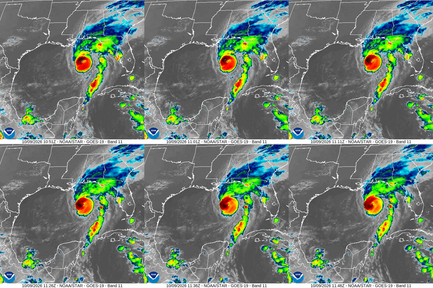
Hurricane Isaias intensified during the past 24 hours or so and is headed in a general northward direction towards the northern Gulf coast with possible landfall around midnight on Friday night. Images courtesy NOAA
Overview
Hurricane Isaias indeed intensified during the past 24 hours and is now right on the verge of classification as a “major” category 3 storm. Landfall is likely around midnight on Friday night near the far western part of Florida’s Panhandle. There can be some weakening of Isaias in the few hours just before landfall due to increasing wind shear; nonetheless, it will remain a dangerous hurricane with heavy rain, damaging winds, and significant storm surge along the Gulf coast. Impacts will extend northward to the Tennessee Valley on Saturday with heavy rain, damaging winds and potentially severe weather to include the risk of isolated tornadoes. Rain and wind will push into the Mid-Atlantic region on Sunday and there can be strong-to-severe thunderstorms mixed into the picture as well.
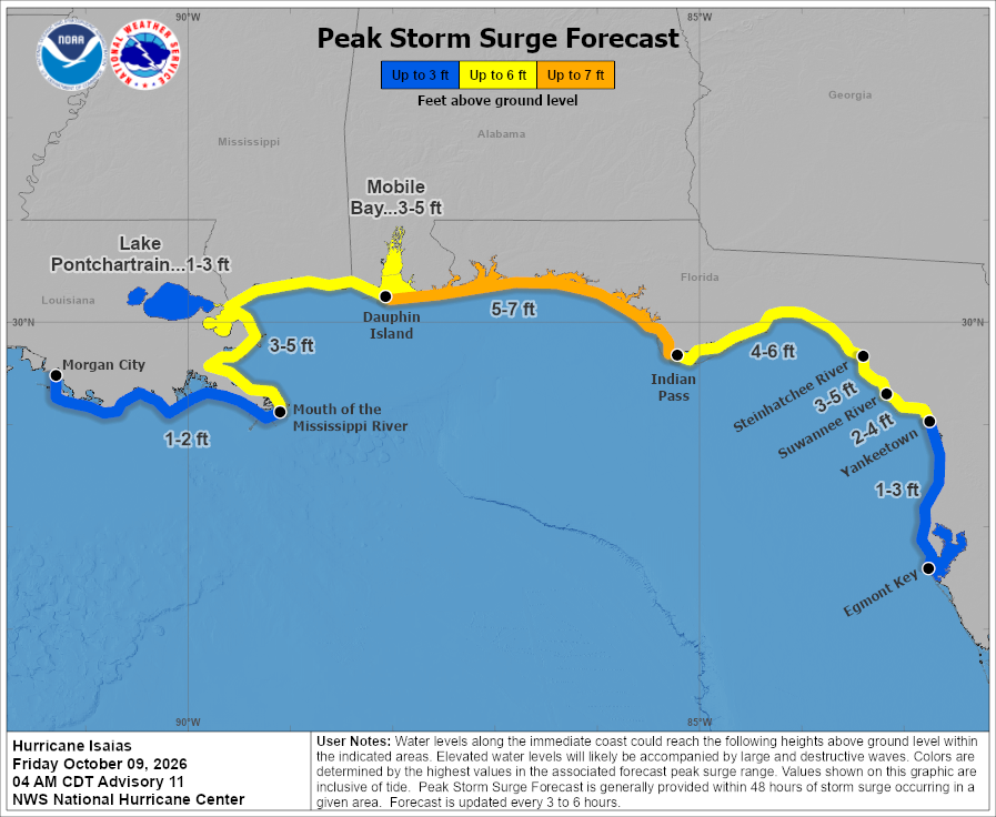
Storm surge will be significant along much of the Gulf coast with landfall likely later Friday night somewhere near the far western portion of Florida’s Panhandle. Map courtesy NOAA
Details
Hurricane Isaias was in a favorable environment for intensification during the past 24 hours or so and indeed it climbed to a strong category 2 storm system with maximum sustained winds of 110 mph and is on the doorstep of reaching “major” category 3 levels (sustained winds of 111 mph or greater). The latest movement of Isaias is to the north-northeast as it becomes increasingly under the influence of a strong upper-level ridging off the SE US coastline. The general northward movement will continue through the rest of the day, and landfall is possible around midnight on Friday night somewhere near the far western part of Florida’s Panhandle. There can be some weakening of Isaias in the few hours just before landfall due to an increase in wind shear; nonetheless, it will reach the Gulf coast as a dangerous hurricane with heavy rain, damaging winds, and significant storm surge.
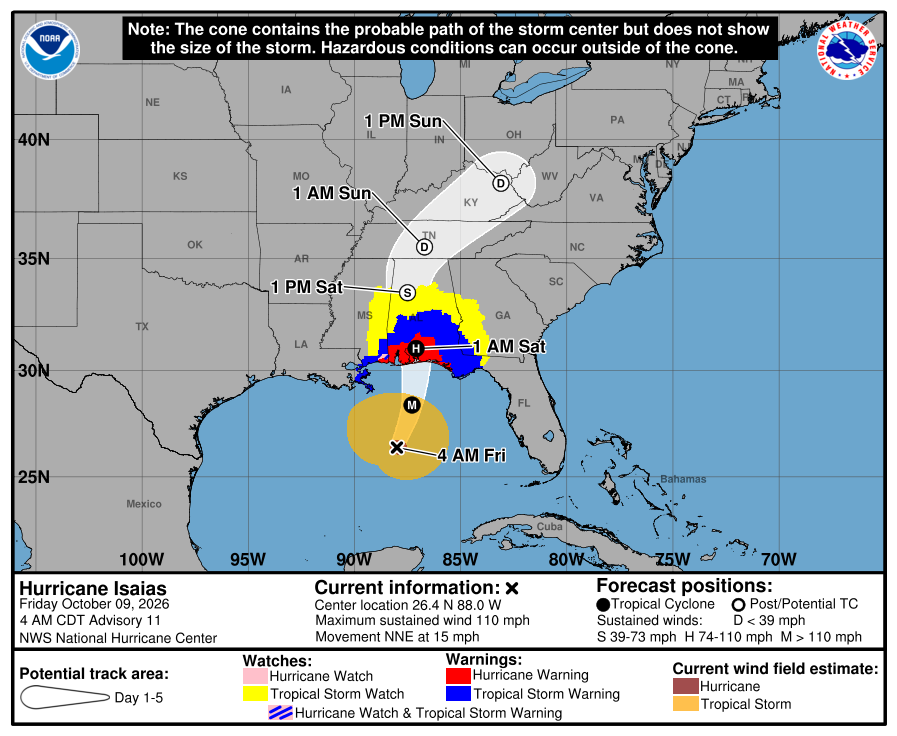
Hurricane Isaias will be under the increasing influence of a building upper-level ridge of high pressure off the SE US coastline. As such, its movement will likely be in a general northward direction during the next 24 hours or so…perhaps even a bit west of north as it heads from the Gulf coast to the Tennessee Valley on Saturday. Map courtesy NOAA
On Saturday, Hurricane Isaias will continue a general northward track pushing into the Tennessee Valley with heavy rains and damaging wind gusts likely to continue well north of the Gulf coast. Watch out for flash flooding all the way into the Tennessee Valley and power outages are on the table. Severe weather will also be possible from late tonight into Saturday night across many of the southern states including Alabama, Georgia, Florida, Tennessee and the Carolinas with isolated tornadoes on the table.
On Sunday, the remnants of Hurricane Isaias will take a turn to the northeast from the Tennessee Valley towards the northeastern part of the country. Rain and wind will extend all the way into the Mid-Atlantic region and Northeast US during the second half of the weekend. There can be some strong-to-severe thunderstorm activity as well on Sunday and some of the rain can be heavy at times. Overall conditions should improve on Monday as the remnants of Isaias push off the Mid-Atlantic/Northeast US coastline.
Meteorologist Paul Dorian
Arcfield
arcfieldweather.com