**Changing weather pattern results in storm that impacts the western states during the next couple of days...southern states this weekend...and some impact possible in the Mid-Atlantic**
Paul Dorian

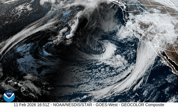
This satellite imagery loop clearly shows a long stretch of clouds associated with the sub-tropical jet stream as it pours moisture into the southern part of California. There is also a swirl of clouds just off the San Francisco coastline associated with a surface low pressure system that will bring rain and snow to the Golden State in the next day or so. Images courtesy NOAA/GOES-W
Overview
The polar jet has dominated the scene in recent weeks across North America resulting in numerous Arctic air masses being transported from western Canada into the northeastern states, but changes are underway as the sub-tropical jet is now showing plenty of life. This changing weather pattern will result in milder conditions across the northeastern states and some much-needed precipitation across the western and southern states after an extended dry stretch. The rejuvenated sub-tropical jet stream is pouring moisture today into southern California while an intensifying surface low pressure spins just off the San Francisco coastline. This system will produce some rain in low lying areas of the Golden State during the next 24 hours or so and significant accumulating snow in the mountains of eastern California.
By the early part of the weekend, this same low-pressure system will re-emerge over the south-central states and Gulf moisture will feed into its southeastern flank. As such, the moisture field will expand - good news for the Deep South where it has been dry - and the risk of severe weather will likely be put back in play in some areas. This system will then move in a general eastward direction and it can have an impact on the Mid-Atlantic region by the latter part of the weekend with mixed precipitation on the table. Much milder weather will follow in Mid-Atlantic/Northeast US later next week after the passage of this storm system off the eastern seaboard.
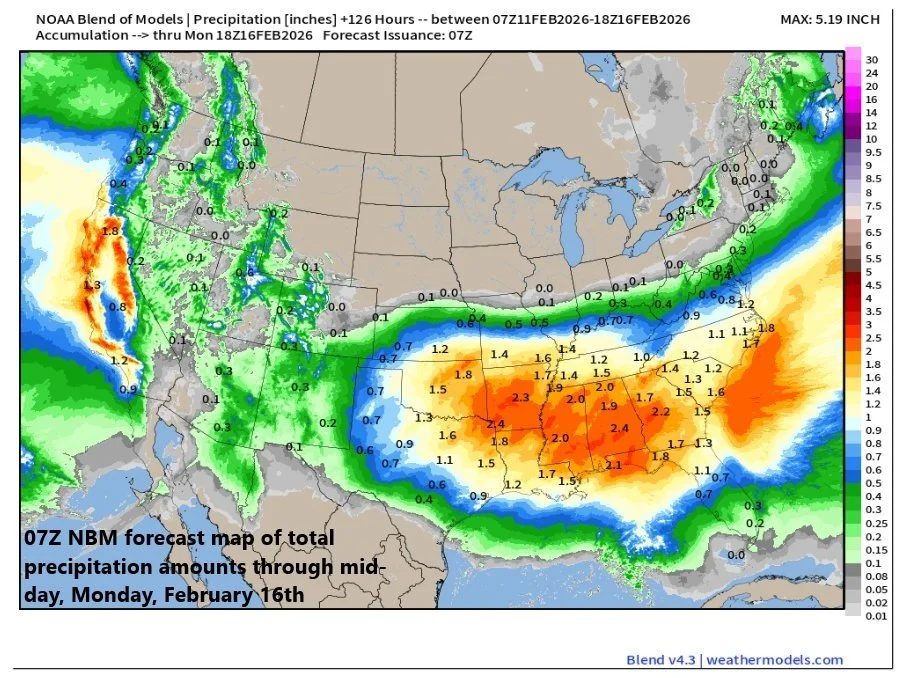
The changing weather pattern featuring an active sub-tropical jet stream will produce some beneficial precipitation to the western and southern states during the next several days where it has been quite dry in recent weeks. Map courtesy NOAA, weathermodels.com
Details
Low pressure is moving into California today from the eastern Pacific Ocean and it will bring some beneficial rainfall to low lying sections during the next day or so and accumulating snow to the higher elevations of the Sierra Nevada Mountains. This system will travel across the southwestern states on Thursday and Friday producing some beneficial rain and snow in that region and then it’ll re-emerge on Saturday over the south-central US. Moist and warm Gulf air will feed into this system on its eastern flank, and this will cause a widening and intensification of its moisture field ultimately leading to some beneficial rainfall across the Deep South where it has been relatively dry in recent days. In addition, the influx of warm and humid air from the Gulf will help to destabilize the atmosphere and we may have to deal with some severe weather across Texas and Louisiana later in the day on Saturday, and this risk can shift eastward by Sunday.
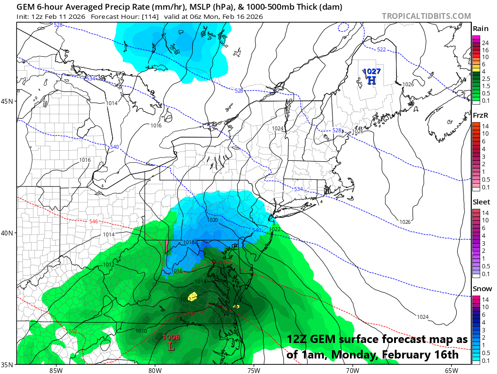
Low pressure could take a route all the way from California today to the Virginia/Carolina coastline by the early part of next week raising the chance for some mixed precipitation in the Mid-Atlantic region by the end of the weekend. Map courtesy NOAA, tropicaltidbits.com
On Sunday, low pressure will head in a general eastward direction from the Middle Mississippi Valley towards the east coast and it be supported by energy aloft and an active sub-tropical jet stream. A second wave of energy to the north will try to “phase” in with the southern system and if this were to happen the surface low could undergo significant intensification by the time it reaches the Virginia/Carolina coastline around early Monday. There is the chance that precipitation could spread into the Mid-Atlantic region late in the day on Sunday or during Sunday night and potentially continue into early Monday depending on the ultimate magnitude and path of this storm system.
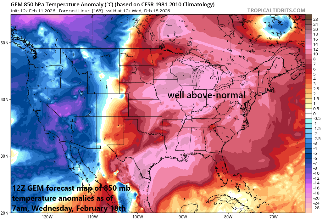
This evolving weather pattern will bring about significant changes in the temperature department to the Mid-Atlantic/NE US which has suffered through some bitter cold conditions in recent weeks. Much warmer weather is likely to push into the northeastern states later next week following the storm system that can potentially have an impact during the late weekend/early part of next week. Map courtesy NOAA, tropicaltidbits.com
In terms of precipitation type, temperatures in the DC-to-Philly-to-NYC corridor will be on the moderately cold side by the latter part of the weekend with no Arctic air mass in place and this would suggest rain or perhaps a mixed bag of rain and snow. In the one scenario whereby “phasing” occurs between the southern and northern waves of energy, strong upward motion could develop around this system potentially resulting in enough “generated” cold air to support accumulating snow; especially, to the north and west of Route I-95. Stay tuned...many details still need to be ironed out. Looking beyond, the evolving weather pattern will likely result in above-normal temperatures for the Mid-Atlantic region and Northeast US by the middle of next week...we’re talking about significantly higher temperatures than what we have suffered through in recent weeks.
Meteorologist Paul Dorian
Arcfield
arcfieldweather.com
Follow us on Facebook, Twitter, YouTube
Video discussion: